The search for missing Malaysia Airlines flight MH370 has found objects of man-made origin on the Indian Ocean floor, but the debris field did not show all the characteristics of a typical aircraft wreckage area, say authorities.
After careful data analysis on the small sonar contacts detected by Fugro Equator’s deep tow system within the southern part of the priority search zone, the objects were flagged “of potential interest but unlikely to be related to MH370,” said Australia’s Joint Agency Coordination Centre (JACC) on Wednesday in an update on the ongoing search.
The aircraft, a Boeing 777-200ER, flying from Kuala Lumpur to Beijing, disappeared off radar over the South China Sea, less than an hour after takeoff on 8 March 2014 with 239 people, including 12 crewmembers on board.
The Australian Transport Safety Bureau (ATSB) is leading the underwater search for MH370 in the southern Indian Ocean.
In order to rule out the find, a further high-resolution sonar scan was performed, followed by low-altitude mission using the automated underwater vehicle.
“The high-resolution data revealed a large number of sonar contacts lying very close to the seafloor, at a depth of around 3900 metres”.
“Analysis of the images this week revealed that the debris was indeed man-made, but indicated that it was actually the wreck of a ship.”
This wreck is previously uncharted and the imagery will be provided to expert marine archaeologists for possible identification.
Earlier this month, robotic submarine scanning in the priority search zone was suspended due to bad weather and rough seas in the area.
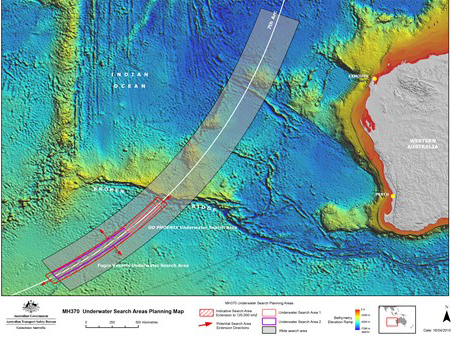
Current underwater search efforts, started 6 October 2014, have involved 4 vessels (GO Phoenix, Fugro Discovery, Fugro Equator and Fugro Supporter) towing deep water vehicles with side-scan sonar, multi-beam echo sounders, and video cameras in sweeping a 60,000 sq km area of seabed. From late January, with the arrival of Fugro Supporter, AUV operations started to scan areas which cannot be effectively scrumbed by equipment on the other vessels.
Over 75% of the seafloor in the existing search area has already been searched with clue found.
Transport Ministers from Australia, China and Malaysia announced on April 16 that they would double the current search zone to 120,000 sq km to “cover the entire highest probability area identified by expert analysis” if no trace of the missing plane is found by late May.
JACC also hinted that the current search zone might be re-adjusted as expert review continues.
“The Search Strategy Working Group continues to review evidence associated with MH370 which may result in further refinement of the search area,” it said.
The extended area will constitute about 95% of the calculated flight path of the plane, but searchers hope they will find a trace in the current search zone by late May.
The high priority search area has been drawn based on “handshakes” between the plane and a communications satellite.
As the plane’s transponders, which transmit the plane’s location to air traffic controllers, were manually switched off from inside the cockpit, hourly satellite pings were the only interaction kept live for hours – after which investigators believe the aircraft ran out of fuel.
Investigators said in the initial report that movements are consistent with the deliberate action of someone on the plane.