6 April, Bangkok, Thailand - UNOSAT delivered an advanced training on the Operational Application of Geospatial Information Technology (GIT) for Disaster Risk Reduction (DRR) for Fiji, Vanuatu, and the Solomon Islands using blended learning formats to ensure maximum engagement of participants despite the challenges of COVID-19 pandemic. This training was offered as part of the capacity development activities of the CommonSensing* project that aims to improve climate resilience in the Pacific small island states.
The GIT4DRR course was designed to respond to the project stakeholders' learning needs in a challenging context. Course contents were prepared to enhance the capacity of technical staff from the partner governments, regional UN offices, and academia with diverse backgrounds and expectations. The course was open to all former participants of CommonSensing training events, however, special attention and priorities were given to female technicians for balanced gender representation. The training delivery mode was adapted to comply with the local COVID-19 restrictions.
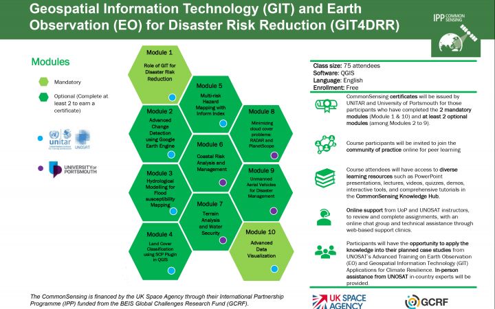
Following the learning needs assessment* conducted during the scoping phase of the project, the diversity of identified stakeholders' expertise was reflected in the GIT4DRR course through its wide span of session topics. Considering the limitations of a traditional classroom setting and COVID-19 preventive measures, UNOSAT innovated the way of training delivery to best meet the learning needs of key stakeholders. UNOSAT and the University of Portsmouth (UoP) developed the course content comprising of 10 modules - 2 mandatory ones and 8 electives covering different types of GIT applications. This course structure allowed each participant to be able to tailor their own curriculum around individual's learning needs and interests. In order to complete the course and get certified, participants were required to take mandatory modules and 2 out of 8 electives.
This self-paced and facilitated course offered all online modules available from 4 December 2020 to 21 February 2021. A period of 3 months provided participants with a continuous learning opportunity and time flexibility. The participants could coordinate their learning time and work schedule taking into account technical limitations during cyclone season, such as power cuts and unstable internet connection. Some assignment deadlines were also modified to accommodate participants who were involved in the emergency responses after Tropical Cyclone Yasa (in December 2020) and Tropical Cyclone Luca (In January 2021). Each module indicated the level of difficulty and expected duration for completion, together with the content description, learning objectives, and supporting material, to help participants choose elective modules matching their needs.
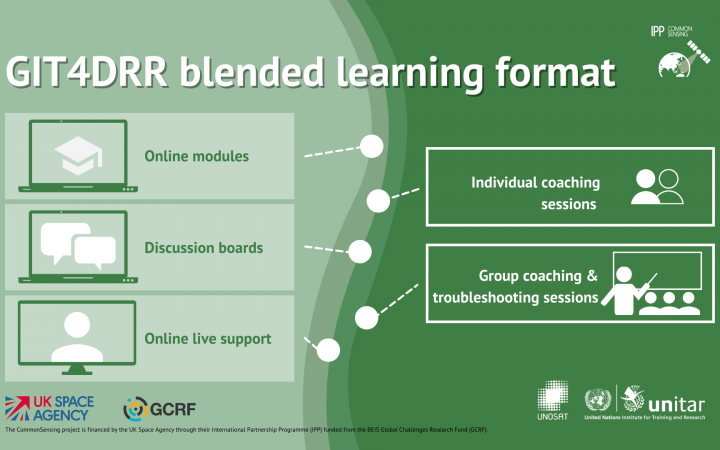
The GIT4DRR e-learning course was hosted on UNITAR's Learning Platform. To replace face-to-face lectures, each session had a recorded presentation and webinars as well as interactive modules voiced over by UNOSAT's in-country staff. Since it was unable to carry the in-person lab exercises owing to COVID-19 threats, participants were invited to follow detailed tutorials available both in text and video formats on the CommonSensing Knowledge Hub. Course participants filled out the assignment forms with adding tables and screenshots, and facilitator and tutors provided grades and feedback online. All content and interactions were also accessible offline through the Moodle app.
To ensure all participants have the best chance of success, both the UNOSAT's Bangkok training team and in-country staff in the Pacific actively supported them online and offline. The participants were encouraged to use the e-discussion boards where support and feedback were provided within 24 hours by tutors and peer groups. Other communication channels, for instance, email or WhatsApp, were also available as appropriate. A system of CommonSensing badges was introduced within the course, such as "Discussion Leader", "Community Champion" or "GIS Guru" to boost participation and improve retention.
As the COVID-19 situation allowed in the partner countries this year, a few in-person supporting sessions were provided by in-country experts. Small groups of participants gathered to benefit from coaching and troubleshooting, and such space helped them to share knowledge and experience with other colleagues.
Overall feedback from 91 training participants from 25 different organizations was very positive. Through anonymous surveys, participants said:
"I would like to say thank you for making this online course available for me, I have learnt lots from it and I believe that strongly agree to use some of the knowledge and skills in my job and that will help the department itself on the decision making."
"This module is very interesting as it is closely related to some of the field work we are interested in among project areas. The module has also shed light into other open software tools (google engine, climate search engine) that can be easily accessed through the internet and used to produce good quality data."
"Module 5 has been the most useful so far to support NDMO/Governments develop their own local systems to help prioritise limited resources to support DM/DRR/CCA type work."
To learn more about the CommonSensing project, please visit www.commonsensing.org.uk or follow @EOCommonSensing.
CommonSensing project, having a consortium of international partners led by UNOSAT, is an innovative international project that aims to support and build climate resilience in Fiji, Vanuatu and the Solomon Islands through the use of satellite remote sensing technology. The project is funded by the UK Space Agency's International Partnership Programme (IPP) financed through the Global Challenges Research Fund (GCRF). UNOSAT has been leading the capacity development activities especially on the satellite data and GIT applications to support the partner governments in their efforts to make evidence-based decisions for enhanced Climate Resilience and DRR.
Learning needs assessment is a crucial step in developing a training programme. The analysis of collected data provides key information on the prospective participants' current capacity levels and available resources, and it helps to define the training scope, learning objectives, course content, and delivery methods.


