Indigenous land cover in Aotearoa New Zealand continued to decline between 1996 and 2023, according to figures released by Stats NZ today. Over the same period, urban land continued to expand.
"The latest version of the New Zealand Land Cover Database (LCDB) shows the cover of our land is continuing to change," environment statistics spokesperson Tehseen Islam said.
"Land cover changes reflect ongoing pressures on natural ecosystems as population and industries grow."
New Zealand's indigenous land cover includes native forests, shrublands, tussock grasslands, and natural bare surfaces like snow-covered mountains.
Since LCDB records began in 1996, indigenous land cover has decreased by 96,522 hectares - an area approximately the size of the Chatham Islands.
In the most recent period between 2018 and 2023:
- Indigenous land cover fell by 8,652 hectares, mostly converted to exotic grasslands (such as pasture for farming) and exotic forest (such as radiata pine plantations).
- Land dominated by exotic vegetation, including agricultural and forestry areas, saw a slight net decrease from its peak in 2018 - conversions in both directions largely balanced out. Nearly all the 11,538 hectares converted to exotic land cover was previously indigenous land cover.
- Urban land, including built-up areas, roads, and dumps, increased by 10,710 hectares. Most of the expansion (94 percent) occurred on previously exotic land. The increase is the equivalent of adding another urban area the size of Napier.
- Freshwater wetlands also continued to decline, though the decrease of 537 hectares between 2018 and 2023 was the smallest since 1996.
| Land cover | Gain | Loss |
| Indigenous | 3743 | -12395 |
| Exotic | 11538 | -14377 |
| Urban | 10879 | -169 |
In 2023, half of New Zealand's land (50 percent or 13.5 million hectares) was dominated by exotic vegetation. Indigenous land cover accounted for a slightly smaller share at 47 percent or 12.6 million hectares. Urban land cover was around 1 percent or 0.3 million hectares.
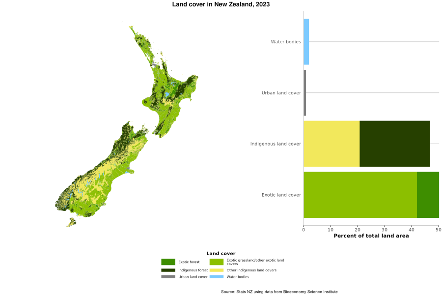
Text alternative for Land cover in New Zealand, 2023
A map of New Zealand on the left shows New Zealand land cover in 2023. A bar chart on the right shows the percent of New Zealand total land area that is water bodies (2 percent), urban land cover (1 percent), indigenous land cover (47 percent, comprises indigenous forest and other indigenous land cover), and exotic land cover (50 percent, comprises exotic forest and exotic grassland/other exotic land cover). The colour green represents exotic forest, light green is exotic grassland/other exotic land cover, dark green is indigenous forest, yellow is other indigenous land cover, grey is urban land cover, and blue is water bodies.
Today, Stats NZ published:
- Indigenous land cover: Data to 2023
- Exotic land cover: Data to 2023
- Urban land cover: Data to 2023
- Wetland area: Data to 2023
Stats NZ publishes and updates environmental indicators on the state of New Zealand's environment as part of a joint environmental reporting programme with partner Ministry for the Environment.


