Observed Oceanic Drivers for the Previous Season
From December 2025 to February 2026 (DJF 2025/26), global sea-surface temperatures (SSTs) were generally above average, with the notable exception of the central and eastern equatorial Pacific.1 Above-average SSTs persisted across the extratropical oceans in both hemispheres. In the equatorial Pacific, below-average SSTs were consistent with a weak La Niña; however, an enhanced east-west SST gradient sustained coupled ocean-atmosphere signals more characteristic of a stronger event, as reflected in the rainfall anomalies.
The Indian Ocean Dipole (IOD) remained near-average. In the Atlantic basin, SSTs were slightly above average, with positive anomalies in both the North Tropical Atlantic (NTA) and South Tropical Atlantic (STA). Above-normal SSTs also persisted across the extratropical North Atlantic.
Outlook for Oceanic Drivers for the Next Season
For the forecast period beyond April 2026, the Niño 3.4 plume shows an exceptionally tight consensus for a rapid transition into El Niño territory by May, with several models suggesting the development of a strong El Niño as early as June/July. While the typical "spring predictability barrier" is evident in the increased spreading of the plumes starting in April/May, the upward trajectory remains consistent across nearly all forecast systems.
Similarly, the IOD index indicates a shift from the neutral conditions observed in early 2026 toward a positive IOD phase by mid-year, with most models converging on an index above +0.5°C by July/August. In the Atlantic, both the NTA and STA are expected to maintain their slightly above-average values throughout the forecast period.
Surface Temperature Outlook for the Next Season
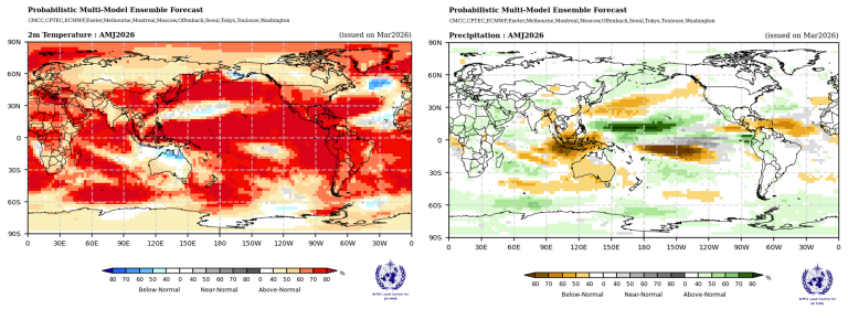
For the April-June (AMJ) 2026 season, multi-model ensemble forecasts indicate a widespread global signal for above-normal land surface temperatures. High model agreement is particularly evident across much of the Northern Hemisphere mid-latitudes between 30°N and 60°N. Elevated probabilities for above-normal conditions are forecast for southern North America, Central America, and the Caribbean, supported by robust model consistency. Europe and Northern Africa also show a moderate to high likelihood of warmer-than-normal temperatures. In contrast, northern Asia and northern North America exhibit only a slight tilt toward above-normal probabilities, with relatively weak model consistency.
In the Southern Hemisphere, enhanced probabilities for above-normal temperatures are projected for much of South America. Southern Africa (south of 15°S) exhibits only a weak enhancement in above-normal probabilities, while most of Australia shows no clear forecast signal, with climatological probabilities expected to prevail.
Across the tropics, strong signals for above-normal warmth are expected over equatorial Africa and the Maritime Continent, reinforced by moderate to strong agreement across forecast systems.
Forecasts over oceanic project widespread above-normal temperatures across the North Pacific, the South Pacific west of 150°W, the South Atlantic, the western North Atlantic south of 30°N, and the equatorial Indian Ocean. Notable exceptions include a band in the North Pacific along 30°N (between 120°E and the Date Line) with a weak enhancement in near-normal probabilities, and a "horseshoe" pattern in the North Atlantic where below- to near-normal probabilities straddle warm anomalies along 30°N. In the equatorial Pacific east of the Date Line, the significantly increased probability of above-normal temperatures reflects that the coupled ocean-atmosphere system is likely to transition into a warm ENSO state.
Rainfall Outlook for the Next Season
For the AMJ 2026 season, the global precipitation forecast is dominated by a strong tropical Pacific signal, characteristic of a rapidly evolving warm ENSO state.
A robust and well-defined pattern is evident across the equatorial Pacific. A broad zonal band of strongly enhanced probabilities for above-normal rainfall (exceeding 70-80%) extends north of the equator from approximately 150°E to 150°W. Flanking this wet signal, two prominent corridors of enhanced probabilities for below-normal rainfall are forecast: one arcing southeastward from the central Pacific toward 90°W, and another stretching across the North Pacific subtropics. Over the Maritime Continent and the eastern Indian Ocean, there is a strong signal for below-normal rainfall, with model consistency remaining high.
In North America, northern regions show no clear signal, while a weak enhancement in probabilities for above-normal rainfall is forecast across Central America. Conversely, a tilt toward below-normal rainfall is indicated over the southern Caribbean. In South America, much of the northern and central interior exhibits no clear signal, though a moderate enhancement in above-normal rainfall probabilities is evident over the northwest.
Over Africa, there is an enhancement in probabilities for above-normal rainfall along equatorial regions, extending northeast into the Arabian Peninsula. Parts of Europe exhibit a weak tilt toward above-normal rainfall. For Australia, the forecast indicates a weak to moderate enhancement in probabilities for below-normal rainfall across most of the continent, except for the northernmost region, where there is a weak enhancement in the probability for near-normal rainfall.
1 https://www.cpc.ncep.noaa.gov/products/attribution/images/Attribution202602.pdf