Devastating rainfall has triggered catastrophic flooding in parts of South and Southeast Asia, claiming hundreds of lives, displacing entire communities and causing massive economic disruption. National Meteorological and Hydrological Services are working around the clock to provide forecasts and early warnings to inform emergency action, whilst the WMO Coordination Mechanism (WCM) is providing expert advice to inform humanitarian operations.
Indonesia, the Philippines, Sri Lanka, Thailand, and Viet Nam are among the countries currently worst affected by a combination of monsoon-related rainfall and tropical cyclone activity.
Asia is highly vulnerable to floods, according to the WMO's State of the Climate in Asia reports . Rising temperatures increase the potential risk of more extreme rainfall because a warmer atmosphere holds more moisture. The latest disasters underline the importance of greater cooperation, as embodied in WMO's regional mechanisms, and of the international campaign to ensure that everyone is protected by early warning services.
"The Asia-Pacific region faces the most intense and frequent tropical cyclone activity in the world. Record-breaking rainfall, storm surges and floods displace millions and cause billions of dollars in economic losses," WMO Secretary-General Celeste Saulo said in a video address to the Typhoon Committee , a joint body of WMO and the United Nations Economic and Social Commission for Asia and the Pacific (UNESCAP).
"No single institution or country can tackle the challenges of typhoons and climate extremes alone. Regional mechanisms like the Typhoon Committee are proof that when we act together, we amplify our impact," she told the Typhoon Committee's Integrated Workshop happening this week in Macau, China, which seeks to upgrade regional cooperation through cross-cutting activities in the North-West Pacific.
Early Warnings for All
The WMO Coordination Mechanism (WCM) plays a key role in curating authoritative weather, water, and climate information from the WMO community to the UN and humanitarian agencies, thereby enhancing preparedness and early response efforts as part of the wider UN Secretary-General's Early Warnings for All Initiative .
Thanks to the information from WMO Members and specialized centres, WCM provided expert advice to UN and humanitarian agencies for these severe events and the possible impacts:
- Monthly Seasonal Climate Outlook Briefings and Scans, highlighting the increased probabilities of above and well above-normal precipitation across several parts of Southeast Asia and the Maritime Continent, and that such prolonged conditions would contribute to increased flood risk in flood prone areas. The seasonal climate outlook for South Asia for October to December said that above-normal rainfall is likely across much of central, eastern, and southern South Asia.
- Global HydroMet Weekly Scan , issued on 20 and 26 Nov, referring to heavy / very heavy rain, intense thunderstorms, strong winds and storm surge (flash floods / landslides / floods likely) in Sri Lanka, south-eastern India, southern Thailand, Viet Nam, western Indonesia, Malaysia and Philippines, including the possible tropical cyclones formation and evolution.
Impacts
Indonesia
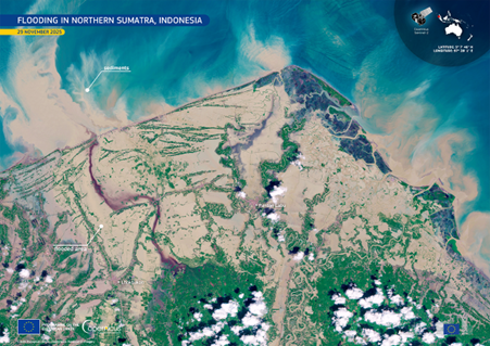
Tropical Cyclone Senyar brought torrential rainfall and widespread flooding and landslides across northern Sumatra in Indonesia, Peninsular Malaysia, and southern Thailand. Tropical cyclones so close to the equator are rare.
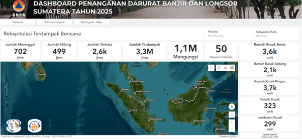
According to the official BNPB (Indonesia's National Disaster Office) emergency dashboard updated on 2 December 2025, severe floods and landslides across Sumatra have resulted in 604 fatalities, 464 missing persons, and approximately 2,600 injured, with 1.5 million people affected and more than 570,000 displaced. A total of 50 districts have been impacted.
Viet Nam
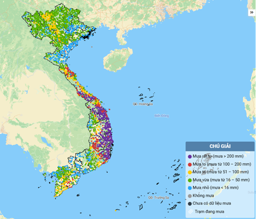
Viet Nam is bracing for yet more heavy rainfall for its south-central region on 2 December, under the impacts of Storm Koto - which earlier hit the Philippines - and a cold front. Exceptional rains over the past few weeks have flooded historic sites and popular holiday destinations and caused massive damage in the order of many millions of dollars, especially to the agricultural sector. Nearly 100 people are reported dead.
From 15 November to 21 November, strong easterly disturbances combined with intensified cold air caused widespread heavy rainfall. Rainfall ranged from 400-700 mm, with some locations exceeding 1,000 mm. Eastern Dak Lak received 700-900 mm, locally above 1,200 mm, according to Viet Nam's National Centre for Meteorological Forecasting.
Severe widespread flooding impacted multiple provinces. Historic flood levels were exceeded on the Ky Lo River, Ba River (Dak Lak), and Dinh Ninh Hoa River (Khanh Hoa).
In late October, one meteorological station in Hue City, in Central Viet Nam, recorded a new national 24-hour rainfall record of 1,739.6 mm. This exceptionally high value is currently subject to a formal WMO extremes evaluation committee, as a value above 1,700 mm would constitute a record for the Northern Hemisphere and for Asia and in fact be close to the highest ever recorded 24-hour rainfall (1,825 mm).
Philippines
The Philippines is still recovering from back-to-back typhoons in early November - Kalmaegi (known locally as Tino), which killed more than 220 people and affected an estimated 2.4 million - and Fung-Wong (Uwan). An unprecedented series of tropical cyclones hit the country already in 2024.
Sri Lanka
In Sri Lanka, nearly one million people are affected and more than 400 reported dead or missing after Cyclonic Storm Ditwah unleashed record flooding and landslides across the island, according to the Office of the Coordination of Humanitarian Affairs.
Cyclonic Storm Ditwah tracked directly down Sri Lanka's east coast and made landfall on 27 November before moving back over the Bay of Bengal, triggering some of the most severe flooding Sri Lanka has seen since the early 2000s. WMO's Regional Specialized Meteorological Centre New Delhi provided guidance products to the countries it serves - and without these the casualties would have been even higher.
The UN in Sri Lanka activated its emergency coordination system to scale up a unified response with government agencies and humanitarian organizations.
According to the UN relief coordination office , OCHA , 998,918 people across all 25 districts have now been affected, with 212 deaths reported and 218 people missing.
Thailand
At least 162 were killed and more than 1.4 million households and 3.8 million people have been affected by floods triggered by heavy rains in 12 southern provinces, according to the Department of Disaster Prevention and Mitigation. In Thailand, as of 1 December, flooding affected a total of 9 provinces, 74 districts, 407 sub-districts, and 2,725 villages, approximately 2.3 million people, with at least 178 fatalities reported. Hat Yai, the largest city in the Southern region, was also affected. The rainfall reached 370.2 mm (equivalent to a 300‑year return period).
WMO Action
In addition to the WCM and regional mechanisms (such as the Typhoon Committee or a similar structure under WMO's long-standing Tropical Cyclone Programme, the WMO/ESCAP Panel on Tropical Cyclones (PTC) in the Bay of Bengal and Arabian Sea), WMO supports countries in predicting flash floods through the Flood Forecasting Framework and Flood Forecasting Initiative (FFI), a real-time forecasting and early warning platform used in over 70 countries.
This system integrates satellite precipitation, radar, and high-resolution numerical weather models to support forecasters in identifying local flash flood threats. The operational backbone includes a network of regional centres and national services trained to interpret and act on the guidance, often hours before rainfall-triggered flooding begins.
Through its Severe Weather Forecasting Programmes in South Asia and Southeast Asia (SWFP), WMO ensures forecasters receive the training and products they need in order to deliver the best services to their users. In South Asia, WMO Members also collaborate through the South Asia HydroMet Forum (SAHF), a sub-regional initiative to enhance the capacity of national agencies to improve weather forecasts, early warning, and climate services that is supported by the WMO-implemented CREWS South Asia Project.
Over the longer-term and boosted by the Early Warnings for All initiative, WMO works with its operational, scientific, development, humanitarian and financial partners to strengthen critical capacities to anticipate, prepare for and respond to such climate-induced hazard events.
WMO officially launched Community of Practice for Flood Forecasting and Warning in October 2025 as a collaborative space for professionals working on flood forecasting, warning, and early action. By fostering knowledge exchange and strengthening technical capacity, we aim to improve flood early warning systems and ensure timely, actionable information reaches those at risk.


