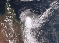
Tropical Cyclone Penny has weakened below cyclone strength and is approaching the Queensland coast as a low.
Bureau of Meteorology Weather Services Manager, Dr Richard Wardle, said there was still a moderate chance the low could re-intensify to cyclone strength, but the most likely scenario is that it will cross the coast as a low.
"Either way, heavy rainfall and damaging winds will be the main impacts," he said.
"A severe weather warning is in place for coastal regions between Alva Beach and Sarina for damaging winds and heavy rainfall which may lead to flash flooding, particularly over the southern flank of the system.
"Heavy rain will initially develop around coastal regions from tomorrow (Tuesday) with isolated falls in excess of 200mm possible.
"Damaging winds with wind peak gusts of around 90 kilometres an hour may develop over the Whitsunday Islands as early as tonight.
"Ex-tropical Cyclone Penny is then forecast to move in a northerly direction along the Queensland coast during the week, bringing heavy falls northern coastal catchments which have already experienced recent heavy rain and may be more responsive."
The Bureau has issued a new Flood Watch today for coastal catchments from St Lawrence to Cape Tribulation including the Mackay, Townsville and Cairns surrounding regions.
Stay tuned for the latest official Warnings on the Bureau's website.


