
27 min read
Introduction
Launched into the night sky nearly 26 years ago, on December 19, 1999, from Vandenberg Air Force Base (now Space Force Base), Terra was NASA's first Earth Observing System (EOS) Flagship mission to study Earth's land surface from space via a coordinated series of polar-orbiting and low-inclination satellites that produce long-term global observations useful for understanding the interactions between Earth's atmosphere, land, snow and ice, oceans, and radiant energy balance. Scheduled for a six-year tour, Terra outlasted its life expectancy by nearly two decades. Despite its longevity, Terra's mission scientists stopped making inclination adjustments in 2020, allowing the satellite to slowly drift out of its contained orbit. The mission team has also begun the painful process of shutting down the five key instruments as the satellite is prepped for retirement.
"Terra's impressive human legacy stems from the fact that the mission's history is grounded in NASA icons," said Nyssa Rayne [NASA Goddard Space Flight Center (GSFC)-Terra Outreach & Communications Coordinator]. "Even today, Terra continues to benefit from legendary figures, including the current project scientist and instrument calibration/validation experts, who have shaped this mission in monumental ways."
An Auspicious Beginning to More Than Two Decades of Science
Terra's mission of discovery was designed to provide a better understanding of the total Earth system. Up to this point, the research community knew very little about how the land interacted with the atmosphere on a regional and continental scale. The community also lacked a way to quantify surface properties, such as albedo, roughness, evaporation rate, and photosynthesis, from satellite data.
Terra was designed, engineered, and programmed to address these knowledge gaps. Often described as a small bus, Terra measures almost 7 m (23 ft) long and 3.5 m (11 ft) across. In the vast expanse of space, however, Terra travels in an orbit around Earth, like a gnat circling the Sphere in Las Vegas. Carried into space aboard an Atlas-Centaur IIAS expendable launch vehicle from Vandenberg Air Force Base, CA, Terra was placed in orbit 705 km (438 mi) above the planet's surface, capturing a viewing swatch from each overpass that could be stitched together to produce whole global images. Its flight path was designed to cross the equator to coincide with the time of day when cloud cover along the equator was at a minimum (10:30 AM local time).
Five Instruments Wrapped in a Silver Package
First named EOS-AM, the concept of the Terra mission was envisioned in the 1980s and implemented in the 1990s. Terra builds on the lessons learned from past pioneering programs, including the Upper Atmosphere Research Satellite (UARS), Landsat, the Ocean Topography Experiment (TOPEX)/Poseidon, and the series of Total Ozone Mapping Spectrometer (TOMS) instruments. After many scientific conversations and arguments, it was finally decided that Terra would carry five instruments capable of gathering data that would benefit a variety of Earth scientific disciplines - see Figure 1. An international effort, Terra carries instruments from the United States, Japan, and Canada that allow scientists to document relationships between Earth's systems and examine their connections. The five instruments include:
Advanced Spaceborne Thermal Emission and Reflection Radiometer (ASTER), which obtains high-resolution images of the Earth at 14 different wavelengths of the electromagnetic spectrum that can be used to create detailed maps of land surface, temperature, emissivity, reflectance, and elevation;
Clouds and the Earth's Radiant Energy System (CERES), which measures Earth's total radiation budget as well as cloud property estimates that enable scientists to clarify the role that clouds play in the planet's radiative flux;
Measurement of Pollution in the Troposphere (MOPITT), which measured the distribution, transport, source, and sinks of carbon monoxide (CO) in the troposphere;
Multi-angle Imaging SpectroRadiometer (MISR), which improves the field's understanding of the fate of sunlight in the Earth's environment, distinguishing between different types of clouds, aerosol particles, and surfaces; and
Moderate Resolution Imaging Spectroradiometer (MODIS), which combines data gathered from CERES and MISR to determine the impact of clouds and aerosols on the Earth's energy budget.

Focusing a Zoom Lens on Earth
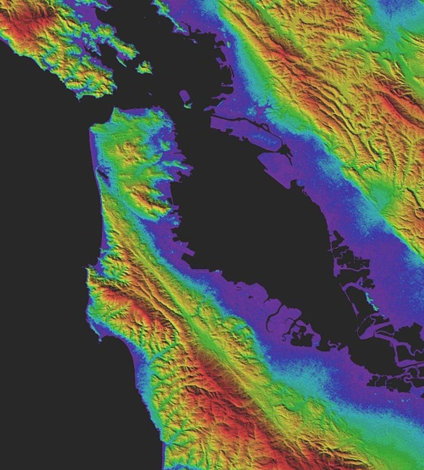
"ASTER's accurate topographic data will be used for engineering, energy exploration, conserving natural resources, environmental management, public works design, firefighting, recreation, geology and city planning, to name just a few areas," Michael Abrams [NASA Jet Propulsion Laboratory-US Principal Investigator] told Universe Today in a June 30, 2009 article.
ASTER was designed to capture high-resolution images of Earth. The data cover a range of land scales - anything from the size of 14 bath towels (15 m2 per pixel) to one-fifth of a basketball court (90 m2 per pixel). The instrument was developed as a partnership between NASA, Japan's Ministry of Economy, Trade and Industry (METI), the National Institute of Advanced Industrial Science and Technology (AIST) in Japan, and the Japan Space Systems (J-spacesystems).
ASTER consists of three telescopes - Visible Near-Infrared (VNIR), Short-Wave Infrared (SWIR), and Thermal Infrared (TIR). (The SWIR is no longer operational.) All three instruments point perpendicular to the direction of motion to change the viewing angle and produce stereoscopic images of our planet. The three telescopes also gather high-resolution images at 14 different bands of the electromagnetic spectrum, ranging from visible to infrared light.
The instrument's data are used to create detailed maps of land surface temperature, reflectance, and emissivity, how effectively a surface emits thermal radiation. ASTER also produces detailed views of the effects of Earth's landforms and topography - see Figure 2. These data are used to understand factors that control climate conditions, e.g., evaporation, water flow, and mass movement. It can also be used to explore how fire can change Earth's surface.
Earth's Reflection Affects Climate
"Earth's climate is really driven by a delicate balance between how much of the Sun's energy is absorbed by the Earth as visible light, and how much the Earth emits to space in the form of infrared radiation," Norman Loeb [Langley Research Center-PI] told EarthSky in a November 30, 2009 article. "The objective is to observe the Earth's radiation budget, together with the clouds…over several years, and preferably over several decades, [that] enables us to improve our understanding of how the climate system is changing and really provides an invaluable resource for testing climate models that are used to simulate future climate change."
Terra maintains two CERES instruments that measure albedo, or solar radiation reflected from Earth's surface, and emitted thermal infrared radiation. It also explores the role that clouds play in modulating radiative fluxes by examining solar-reflected and Earth-emitted radiation from the land surface to the top of the atmosphere.
CERES was developed at NASA's Langley Research Center. The satellite has two instruments onboard. One instrument gathers information using cross-track scan mode, where a mirror sweeps back and forth, perpendicular to the sensor's path. This mode builds two-dimensional images of Earth. This data contributes to the Earth Radiation Budget Experiment and the Tropical Rainfall Measuring Mission. [PLEASE REVISIT THIS EXPLANATION. ] The second CERES instrument gathers information in biaxial scan mode, where scanning occurs along two different axes simultaneously. The data provide angular flux information to derive Earth's radiation balance.
Researchers pair CERES data with other instruments on Terra to create a fully resolved global diurnal cycle of Earth's radiation budget at the surface and at different layers of the atmosphere, including the top of the atmosphere. The CERES data products capture variations in Earth's radiation budget at hourly, daily, and monthly timescales. Climate, weather, and applied science research communities use this data to address a range of research topics that involve the exchange of energy between Earth and space and between the major components of the Earth system - see Figure 3.
Checking in on the Lower Atmosphere from Space
MOPITT was designed to obtain information about the lower atmosphere, especially as it interacts with the land and ocean biospheres. It was developed as a joint project between the Canadian Space Agency, the University of Toronto, and the National Center for Atmospheric Research (NCAR) in Boulder, CO. The instrument has a spatial resolution of 22 km (14 mi) and covers a swath of Earth's surface about half the size of Los Angeles [640 km (398 mi)].
MOPITT uses gas correlation spectroscopy to measure the concentration, fate, and distribution of CO, a product of car exhaust, forest fires, and factory exhaust. MOPITT offers near-global coverage every three days of the region being scanned - see Figure 4. These data help scientists identify sources of regional pollution, monitor regional pollution patterns, and track the long-range transport of pollutants.
MOPITT was the longest running record of CO concentration collected from space. The dataset is often combined with MISR data to map aerosols and CO to track sources of air pollution. On April 9, 2025, MOPITT was the first casualty of Terra's slow demise. It was turned off to conserve energy for the remaining four instruments.

Focusing on the Tiniest Particles from Multiple Perspectives
"The MISR team has pioneered novel methods for tracking aerosol abundances and particle properties, cloud and aerosol plume heights, height-resolved wind vectors, ice and vegetation structures, and other physical attributes of our planet," said David Diner [NASA/Jet Propulsion Laboratory-MISR Principal Investigator]. "These efforts and those of the broader scientific community have led to key insights about how the Earth's climate and environment are changing."
MISR was developed at NASA's Jet Propulsion Laboratory to measure variations of surface and cloud properties as well as aerosols - see Figure 5. These data are used to evaluate the long-term interactions between sunlight and aerosols in the atmosphere and on Earth. Researchers can use MISR data to monitor the monthly, seasonal, and long-term trends in the amount and type of atmospheric aerosol particles.
MISR trains its nine cameras on Earth to capture images from multiple angles that gather reflected sunlight scattered by Earth's surface, clouds, and suspended airborne particles within a 360 km (224 mi) swath of land. One camera points to the lowest point, while others provide forward and aft-ward view angles at 26.1°, 45.6°, 60.0°, and 70.5°. As MODIS flies overhead, each region of the Earth's surface is successively imaged by all nine cameras in each of four wavelengths that span the visible and infrared spectrum. Its capabilities allow measurements of natural and human-caused particulate matter in the atmosphere, particulate abundance and type, heights of aerosol plumes and cloud tops, along with their speed and direction of motion and the types and extent of land surface cover.

According to Diner, outdoor airborne fine particulate matter constitutes the largest environmental health risk worldwide. This fine particulate matter are responsible for millions of premature deaths per year as well as a wide range of adverse human health outcomes. Terra revolutionized the study of these particles, making it possible for researchers to distinguish aerosols resulting from natural and anthropogenic sources and to investigate how different types of aerosols impact human health. Diner points to how MISR data has been used to examine particulate matter in regions of rapid urbanization, such as Asia and North Africa, as well as track aerosol transport after wildfires.
"MISR's greatest achievement is the diversity of scientific investigations and research papers that have resulted from its unique observational approach," he said. Diner also points to the associated retrieval algorithms, which have produced an unprecedented data record spanning more than two and a half decades.
The Swiss Army Knife in Terra's Toolkit
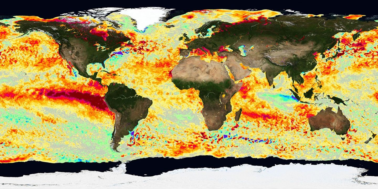
MODIS was designed to monitor atmospheric, land, and oceanic processes, including surface temperature, ocean color, global vegetation, cloud characteristics, temperature and moisture profiles, and snow cover. The instrument was developed at NASA's Goddard Space Flight Center. It provides large-scale coverage, about 2300 km (~1429 mi) of land at a spatial resolution of 250 m (~820 ft). MODIS can visualize every point on Earth every one to two days. This approach is ideal for tracking a variety of Earth's systems. It measures the distribution and properties of clouds, as well as aerosols, water vapor, and temperature. MODIS data are also used as input to a radiative transfer model that calculates radiative fluxes at the surface and within the atmosphere.

Figure credit: Moderate Resolution Imaging Spectroradiometer Land Rapid Response Team, NASA's Godard Space Flight Center
MODIS data helps scientists determine the amount of water vapor in a column of the atmosphere and the vertical distribution of temperature and water vapor, measurements that are crucial to understanding Earth's climate system. MODIS also uses visible images and remotely sensed data to monitor changes in land cover by natural forces, such as fires, or anthropogenic changes, such as cropland burning and farming. MODIS data helps researchers understand photosynthetic activity of plants on land and in the ocean to improve estimates of the gaseous mixture in the atmosphere. MODIS data also improves weather models and forecasts that can prepare communities for major storm events - see Figure 6.
Researchers combine atmospheric models developed using MODIS data with aerosol products from MISR data to create a generation of maps of near-surface particulate matter concentrations that have been used in numerous health studies. One such study is the Global Burden of Disease, which estimates that more than four million premature deaths occur each year due to exposure to airborne particles.
Data, Data Everywhere, Managing Decades of Information
Terra instruments have been in operation since the satellite was launched more than a quarter of a century ago. The technology at the time was state-of-the-art, allowing Terra to complete more than 100,000 orbits, downloading and transmitting data twice during each orbit to ground stations in Alaska, Norway, and NASA's Wallops Flight Facility. Terra has produced the longest record of environmental data providing the research community a way to evaluate the effects of natural and human-induced changes in the environment.
The five instruments gather near real-time data for use in monitoring and managing on-going events. The vast amount of data has generated 87 data products that are distributed through the Land Processes Distributed Active Archive Center (LPDAAC), the Atmospheric Science Data Center (ASDC), the Ocean Color Web, the Atmosphere Archive and Distribution System, and the National Snow and Ice Data Center (NSIDC). The datasets work in concert with other data products to expand the scientific community's knowledge about Earth systems, resulting in more than 27,000 scientific publications.
The EOS Data and Information System


