Meteorologist Jonathan How: Hello from the Bureau, with another update on the developing tropical cyclone over far north Queensland
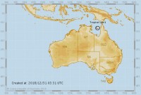
Over the last 24 hrs, this tropical low in the Coral Sea moved across the Cape York Peninsula and into the Gulf of Carpentaria. With favourable conditions for development, there's now not much from stopping this system from further intensifying into a tropical cyclone. And when it does, it will be named Tropical Cyclone Penny.
The low is currently sitting over eastern Gulf waters and is forecast to do a u-turn on Monday night, with a high chance of reaching tropical cyclone status by Tuesday morning. As such, there is a tropical cyclone warning for coastal and adjacent inland areas between Cape Keerweer and Cape York for gales within 24 hours, and a tropical cyclone watch for remaining areas between Kowanyama and Saibai Island in the Torres Strait for gales within the next 48 hrs.
Once the tropical cyclone forms, it's expected to keep moving east and head back for the Gulf coast and at this stage, landfall is expected on Tuesday afternoon or evening near Aurukun. It will weaken as it moves over land and will head out over the Coral Sea once more.
Away from the Gulf, and heavy rainfall continues to fall across the north-east Queensland coast as the tropical low drags in moisture from the Coral Sea. Flooding will be a particular concern, with locations such as the Daintree already recording almost one metre of rain in the past week, and we could see similar totals over the coming days.
A separate severe weather warning for this heavy rain covers coastal parts north of Cairns, and damaging winds and abnormally high tides could also impact the Torres Strait Islands. A flood watch is still current for the region, and moderate flooding continues for the Daintree River, so do keep an eye on these if you are in the area.
From Wednesday, computer model consensus has grown that the low will continue to move east and over the Coral Sea where it could re-intensify, and by Thursday it should be well off the Queensland coast. Beyond this, some models do have the system re-curving back towards land, however there is still significant uncertainty this far out.
So if you're in far north Queensland over the New Year period, it's important to stay up to date with Bureau warnings as tropical cyclone situations can change quickly. And remember to always follow the advice of your local emergency services.