What is an extratropical low?
Low pressure systems are common in southern Australia, particularly in the cool half of the year. These are often called extratropical cyclones or lows. This distinguishes them from tropical lows and cyclones in northern regions. One well-known type of extratropical low is an east coast low.
Some of these lows bring major impacts. These include heavy rain, flooding, strong winds, rough seas, and coastal erosion. Even less severe systems bring important rainfall to parts of southern Australia. This is vital for crop and pasture growth. In fact, lows cause at least a third of all rainfall in southern Australia, and more than half of all heavy rain days.

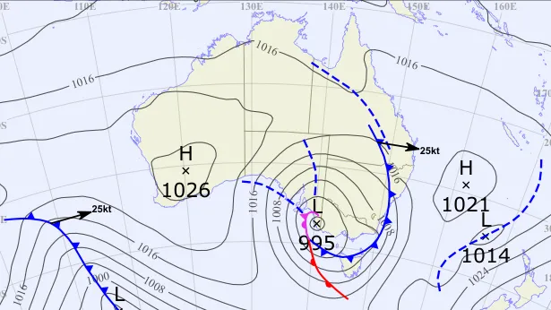
The weather map on 26 July 2025, showing an extratropical (995h Pa) low pressure system near Victoria.
Recent changes in extratropical lows

We have long expected that a warmer world will have fewer lows near southern Australia. But the number of lows can vary a lot from year to year. There is also a wide range of datasets and methods for studying extratropical lows, when compared to their tropical cousins. This can make it harder to see if projected changes have already started happening.
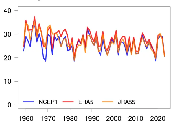
We used the latest data to extend our record of low pressure systems back to the late 1950s. The study finds a decrease in lows near southern Australia between May and October. This means that in 2000-2023 there were about 8% fewer days each year with a low near southern Australia than in 1959-1999. This is the case even though some recent years, such as 2022, had large numbers of lows.
The diagram shows the number of May to October days with a low near southern Australia. Coloured lines show lows using 3 different global datasets.
Future extratropical lows
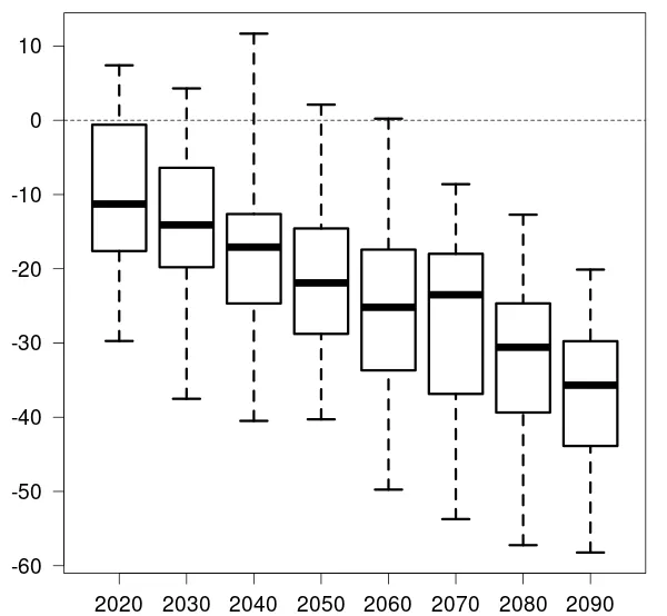

Recent modelling shows that the changes are very likely to continue. For every degree the planet warms, southern Australia is projected to see a 9% decline in the number of lows. All models agree that lows will become less frequent, particularly during May to October. The total decrease is more than 30% by the end of the century under a high warming scenario.
The diagram shows the change in the number of May to October lows near southern Australia under a high warming scenario. Each box shows the percentage change for one 20-year period when compared to 1980-2009. The black line shows the middle change across all models, and the dashed lines show the range. By 2080-2100 (shown as 2090) the range is 20-60% decline, and the best estimate is a 36% decline.
Implications for rainfall and hazardous weather
Rainfall has decreased across southern mainland Australia during the cool half of the year in recent decades. This is particularly clear in south-west Western Australia. It's also seen in parts of south-eastern Australia and near the east coast. Our recent research suggests at least half of the decline in cool-season rainfall since 1959 is linked to decreases in rain from lows. The changes are consistent with modelled and projected changes for this region. Changes in cyclone frequency also explains a large part of future rainfall declines.
It's harder to identify changes in rare but very intense events, such as severe east coast lows. In a warmer world there will be more moisture for heavy rainfall, and higher sea levels. This could lead to larger future impacts from these storms.
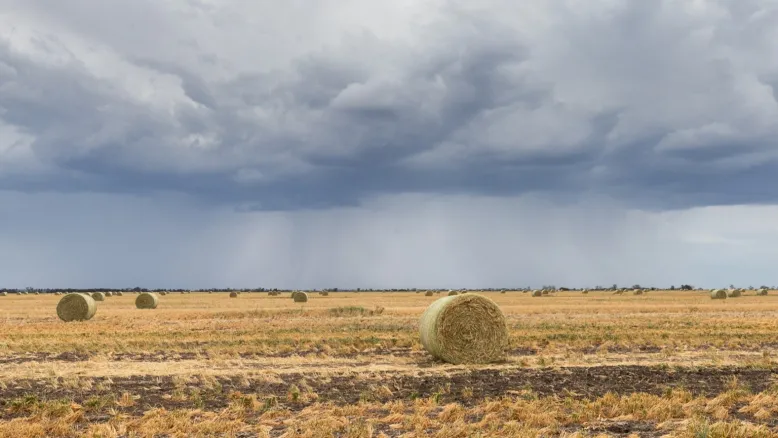
The rain brought by extratropical lows is important for agriculture
Planning for the future
This research is part of the National Climate Risk Assessment. It will help people plan for future changes in severe weather and water security.
The research was conducted by the Bureau of Meteorology and Australian Climate Service.


