The development of meteorogical services in the Caribbean
In early September 1931, a hurricane was observed by ships moving westward through the Caribbean Sea. The ships tried to avoid the system for their own safety and, as weather observations were sparse at the time, they transmitted the information to the telegraph operator in Belize City who conveyed it to the British governor of British Honduras, as Belize was known at the time. The hurricane was expected to cross the country on the afternoon of 10 September. Belizeans celebrate 10 September as the Battle of Saint George's Caye, a Public and Bank Holiday with citizen parades through the cities and towns. The governor advised local authorities that the parade should proceed as scheduled in the morning but that revelers should return to their homes immediately after to await the passage of the storm.
On 10 September the eye of the Category 5 hurricane crossed Belize City bringing with it a 15-foot (10- metre) storm surge. The hurricane destroyed Belize City and claimed over 3 000 lives. My father was seven years old at the time. The storm surge lifted his home, with him, his father, mother and four siblings inside, and deposited it about 100 yards from its foundation. Fortunately, none of them perished.
Thirty years later, Hurricane Hattie, another Category 5 hurricane, crossed Belize City on 31 October 1961, with another 15-foot storm surge. Belize City was destroyed once again, this time 400 lives were lost. WMO had just marked its 10th year and there was now a rudimentary hurricane warning system in place in the region, based a on weather observation stations that were transmitting data to global and regional forecasting centres. Aircraft were dispatched on reconnaissance missions into the Atlantic from bases in Puerto Rico and Trinidad to identify any areas of potential development. Hattie was also one of the first hurricanes to be observed by a polar-orbiting satellite. My father evacuated my mother, my sister and me into the interior of the country one day before the hurricane struck. We remained there for six months until the city had returned to some semblance of normalcy and schools had reopened.

I do not recall ever thinking about weather and climate during my childhood and teenage years. However, my Sixth Form mathematics teacher who happened to be the country's Chief Meteorologist offered me a position as a weather observer upon graduation. This was the start of my career in meteorology which lasted 34 years. Subconsciously, did my family's experience with these major weather events influence my decision to embrace meteorology and climate change as a career path? The opportunity provided by my teacher certainly opened the door.
These are our stories.
Decolonization
The 1950s and 1960s were exciting but tumultuous years. The world was recovering from the Second World War. New international global governance and financial institutions had been created following the war: the United Nations , the World Bank , the International Monetary Fund (IMF), the International Civil Aviation Organization (ICAO), the International Maritime Organization (IMO) and in 1950, the World Meteorological Organization (WMO). The fervor of nationalism was rampant among colonial peoples; empires were crumbling, and their colonies were clamoring for independence. The British colonies in the Caribbean were no exception, however, the British authorities proposed a different path for them.
The British government of the day believed that their colonies in the Caribbean were too small and had limited human capital, natural resources and potential to succeed as independent states. They proposed that the territories be amalgamated into a federation and become one independent nation. The political leaders of several of the territories agreed and the West Indian Federation was born on 3 January 1958. Federal institutions were formed. The British Caribbean Meteorological Service, which had been established in 1951 became the West Indies Meteorological Service with its headquarters in Port of Spain, Trinidad. Forecast offices were established in the Bahamas, Jamaica and Trinidad. The other territories had weather observation stations that relayed data to the forecast offices, which in turn generated and transmitted weather forecasts and warnings to Members. The forecast offices were manned by personnel from the region. Basic training was provided at the Port of Spain headquarters while the staff went to the British Met Office College for more advanced training as forecasters, climatologists and instrument technicians. However, the federation did not last, it was dismantled on 31 May 1962. The Federal Meteorological Service did not survive either, and the staff were dispersed to their countries.
With no Federal Meteorological Service to provide weather services and warnings, newly independent Caribbean States and self-governing territories formed the Caribbean Meteorological Service (CMS) in 1963. Responsibility to provide weather services was assigned and divided among the Members. But Governments recognized that a more formal institutional mechanism would be required to adequately serve the region. Consultations and negotiations commenced, and the Caribbean Meteorological Council of ministers held its first meeting in 1962. The Caribbean Meteorological Institute (CMI) was established in 1967 as a training centre and an agreement in 1973 established the Caribbean Meteorological Organization (CMO).
One of the former officers of the Federal Meteorological Service was Belizean, Kenrick Leslie. A forecaster in Trinidad in 1961 during the passage of Hurricane Hattie, he recalled the pilot of the hurricane reconnaissance aircraft saying in a Texan drawl, "All is gone; all is gone". Upon completing his degree at the University of the West Indies, he returned to British Honduras in 1966 where he was assigned to the Civil Aviation Department, which provided aeronautical and rudimentary meteorological observations to support aviation. Weather forecasts were provided to Belize by Jamaica, which had begun doing so during the period of the Federal Meteorological Service. Recalling his Hurricane Hattie experience, the new Chief Meteorologist was determined that Belize should have its own weather service. British Honduras had been granted self-government in 1962, and his aspirations fell on fertile ground: Premier George Price tasked him to develop a full-fledged meteorological and hydrological service for the country.
Former colonies, like Barbados, Jamaica and Trinidad and Tobago, joined WMO as they achieved independence. The Dutch became WMO Members as the Netherland Antilles, however, self-governing colonies like Belize were WMO Members as part of the British Caribbean Territories (BCT). This enabled Mr Leslie to receive technical support from WMO to develop the Service. He brought the diverse weather observing stations operated by the agriculture, civil aviation and forest departments under one umbrella, standardizing the equipment and implementing uniform observing practices and procedures as mandated by WMO. The weather stations were upgraded through the WMO Technical Assistance Programme. Personnel were recruited and received fellowships to the United Kingdom and the United States of America (US) under the WMO Voluntary Cooperative Programme (VCP). By the mid 1970s the name of the country had been changed to Belize and the Belize Weather Bureau had been established as a separate government department - no longer a part of the Civil Aviation Department.
On 21 September 1981, Belize achieved independence and was admitted into the United Nations the following day. On 23 June 1982, Belize became a Member of WMO.
Development
As a Member, Belize could access all the resources of WMO to develop hydrometeorological services for socioeconomic development. The Belize Weather Bureau became the National Meteorological Service (NMS) in 1982.
Meteorological Services in the Caribbean had all developed to provide support to aviation and to provide warnings of severe weather. The threat posed by tropical cyclones to the entire region - including the Caribbean, Central America, Mexico and the US - galvanized their cooperation in the exchange of data, training and the provision of technical assistance. WMO played an instrumental part in this and the WMO Regional Association IV (RA IV) Hurricane Committee was established. It was a major achievement when the region received nine modern 10-cm weather radars in 1970 through a WMO/ United Nations Development Programme (UNDP) project funded by Japan. These were deployed in Antigua, Barbados, Belize, Cuba, Guyana, Jamaica, and Trinidad and Tobago and were manned and maintained by local meteorological personnel.
The weather services developed and expanded rapidly during the 1970s. With the support of WMO, more staff were trained at the technical, graduate and post-graduate levels. Automatic weather stations, radio weather facsimile, and satellite Earth stations were procured through WMO technical assistance programmes. Products were developed and provided for the public, agriculture, forestry, tourism and all socioeconomic sectors reliant on the weather and climate. Recognizing the capacity of the staff, their technical expertise and the maturity of the Belize Weather Bureau, the US moved its rawinsonde station and marine broadcasting equipment from Swan Island to Belize in 1978.
CMI was now providing training for weather observers, climatological and instrument technicians, forecasters and, in collaboration with the University of the West Indies , offering undergraduate degrees in meteorology. The radar in Barbados had been installed on the compound of the CMI. CMI also served as an archiving and quality control repository for the region's meteorological data, a regional instrument calibration centre and a warehouse for meteorological instruments and radar spare parts. With the support of the Dutch Government, the Caribbean Operational Hydrological Institute (COHI) was established in 1982 on the compound of the CMI; both institutions were amalgamated in the mid-1980s and officially became the Caribbean Institute for Meteorology and Hydrology (CIMH) in 1999.
In the 1960s Barbados and CMI had become the node in the Caribbean for tropical research. Florida State University conducted field expeditions utilizing aircraft and ships, and enhanced ground and upper air observations. In 1974 the region contributed to the GARP Atlantic Tropical Experiment (GATE) which studied tropical systems moving across the Atlantic from Africa to the Caribbean. Our understanding of the structure, development, evolution and trajectory of tropical waves and tropical cyclones came through the data gathered in the field experiments conducted in the 1960s and 1970s in the region.
At the international level Caribbean meteorologists joined WMO as staff members. They were elected to posts in the Organization, serving as presidents of RA IV and Vice-Presidents of the World Meteorological Congress and WMO Executive Council.
The New Agenda
In 1962, British Honduras was granted self-government. Local elected representatives assumed responsibility for all the affairs of government except for foreign affairs and defense. This new national government was responsible for the reconstruction of the country following the passage of Hurricane Hattie. They decided to move the capital from Belize City into the interior of the country away from the devastating effects of hurricanes, knowing that there would be more threats in the future. A new city, Belmopan, was hewn out of the forest 50 miles inland and 250 feet above sea level in what may have been the first climate change adaptation and retreat project undertaken in the world even before the threat of climate change had been recognized.
The threat posed by climate change and sea-level rise to small island and low-lying developing States convinced the UN General Assembly in 1990 to establish the Intergovernmental Negotiating Committee to draft a convention on climate change. I had been promoted to the post of Chief Meteorologist by that time and was assigned the task of leading the Belize delegation at these negotiating sessions. The Bahamas, Guyana and Jamaica also had meteorologists either leading or on their delegations and the Caribbean Community (CARICOM), through the Alliance of Small Island States (AOSIS), ensured that the discussions were informed by the science and the best available data. These interventions resulted in projects to enhance the observing networks in Central America and the Caribbean.
The first of these was a project funded by Finland in Central America, which opened the door for Belize. While support to aviation stimulated the development of meteorological services in the Caribbean, it was support to agriculture and hydropower which drove the development of hydrometeorological services in Central America. A Regional Committee of Hydrological Resources (Spanish acronym, CRRH) had been formed to coordinate hydrological and meteorological services. Belize joined CRRH to access all the resources of the FINNIDA project such as meteorological and hydrological monitoring equipment, service vehicles, consultants and training. Through CRRH, Belize undertook its first climate change vulnerability studies in agriculture, coastal zone and water resources. Finland then funded a similar project in the Caribbean, which focused on strengthening the meteorological observing network, the instrument calibration centre at CIMH and capacity building.
Twelve sea-level rise monitoring stations were installed in the region under the Caribbean Planning for Adaptation to Climate Change (CPACC) project, the first regional climate change project funded by the Global Environmental Facility (GEF). The tide stations were upgraded under the successor project, Mainstreaming Adaptation to Climate Change (MACC) which also installed 12 Continuously Operating Reference Stations (CORS) at the sites to monitor changes in elevation.
During this period, the CARICOM Heads of State mandated the establishment of the Caribbean Community Climate Change Centre (CCCCC). As the Chief Meteorologist and the Focal Point to the United Nations Framework Convention on Climate Change (UNFCCC), I was tasked with drafting the proposal and lobbying for Belize to host the Centre. With a final nudge by Prime Minister Said Musa, Belize won the bid, and I was asked to set up the Centre.
Fortunately, the paths of Belize's first Chief Meteorologist and I were to cross again. Having retired as Chief Meteorologist in 1981, Mr. Leslie had migrated to the US where he went into the LIDAR technology field, achieved a PhD and eventually became a Chief Scientist at Honeywell. He retired and returned to Belize in 2012 as we were looking for the first Executive Director of the CCCCC. Dr Leslie welcomed the challenge, and set about establishing his second institution in Belize, but this time at the regional level.
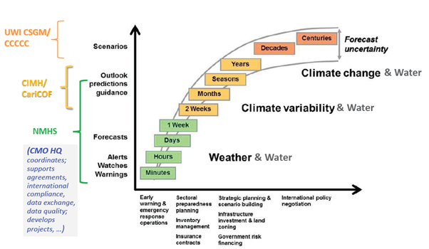
CARICOM now has several regional weather, water and climate institutions: CMO, CIMH and CCCCC. In 1991, it also created the Caribbean Disaster Emergency Management Agency (CDEMA) and, in 2007, the Caribbean Catastrophe Risk Insurance Facility (CCRIF) to provide insurance coverage to limit the financial impact of hurricanes and other natural hazards. The global community now recognizes that climate change is producing rapid changes in seasonal patterns, increasing the frequency and intensity of extreme weather events such as droughts, intense rainfall, floods and hurricanes. In response, governments and UN agencies are developing programmes to address these challenges. The Caribbean has the institutions to implement such programmes cost effectively.
CMO continues to coordinate the region's NMHSs through its representation at WMO and other relevant fora while developing project proposals for strengthening the delivery of services by its Member States. CIMH is now a WMO Regional Training Centre and Regional Climate Centre. It runs regional weather models for the NHMSs and wind, rainfall and storm surge models during severe weather events on behalf of CCRIF to validate insurance claims. It executes projects supporting agriculture, flood forecasting and water resource management. CDEMA coordinates the region in mitigating and responding to both natural and manmade disasters; CCRIF provides insurance coverage for hurricanes and flooding, and CCCCC coordinates the region's response to climate change.
The region is thus well poised to access support through initiatives such as the Climate Risk and Early Warning Systems (CREWS), the UN Secretary-General's Early Warnings for All Initiative and the Systematic Observing Financing Facility (SOFF). The five Caribbean regional institutions are making the best use of the resources available to ensure that they are equipped to provide services to foster socioeconomic development and the safety of the Caribbean people.


