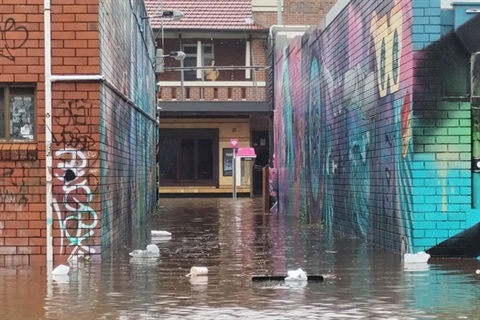
Council is investigating the flooding event in the Byron Bay town centre and Suffolk Park yesterday (30 March 2022) which saw many homes and businesses inundated with water.
The Bureau of Meteorology gauges recorded 319mm of rain at Coopers Shoot and 282mm in Byron Bay in the 24 hours to 9am yesterday morning.
That amount of rain alone would ordinarily have caused flooding in Byron Bay, but the already soaked catchment is believed to have exacerbated the problem with no water being absorbed into the ground.
The intensity of the rain was beyond the capacity of Council's drainage pipe network.
In addition to this, the level of the ocean is currently higher than normal due to spring tides,so water flowing out of Belongil Creek and Tallow Creek was slowed considerably when the ocean was pushing against it.
Phil Holloway, Infrastructure Services Director, said it was terrible to see the flooding of homes and businesses in Byron Bay and Suffolk Park.
"It's incredibly sad to see this flood event on top of everything else we've experienced, not only in the last month, but during the pandemic as well," Mr Holloway said.
"The town of Byron Bay is actually very flood-prone when we get heavy rain," he said.
"As soon as we could yesterday we started checking the drains for blockages.
"The Clarks Beach drain was blocked and we did clear that yesterday afternoon and that helped some of the water get away.
"Normally that drain, which silts up with sand, clears itself when there is heavy rain but that didn't happen this time.
"We didn't find any other major blockages in the network," Mr Holloway said.
It's estimated a drainage upgrade in Byron Bay will cost around $15 million and Council has applied for funding for this project, but so far has been unsuccessful, in getting Government grants to enable this work to get started.
"This drainage upgrade is a top priority for us but the cost is beyond the capacity of Council," Mr Holloway said.
"Flooding in any business or household is not something we want to see and we will continue to apply for grants for this important project," he said.
Anyone who did experience flooding in Byron Bay and Suffolk Park, or any other area of the Shire, is asked to make marks to show the height of the water.
They can also do a survey on Council's website and provide specific details about the time of the flooding, water levels and provide photos or other information.
This information is valuable as engineers will use it to map the flows of water and gather data for grant applications and it identify any new issues.
Surveyors will be out and about in the streets in the coming days and weeks looking at flood heights.
….ends