-

The REVISE-II modeling tool developed at ORNL supports decision-making for electric vehicle charging infrastructure development along interstate highways in support of intercity travel. Credit: Jason Richards/ORNL, U.S. Dept. of Energy
-
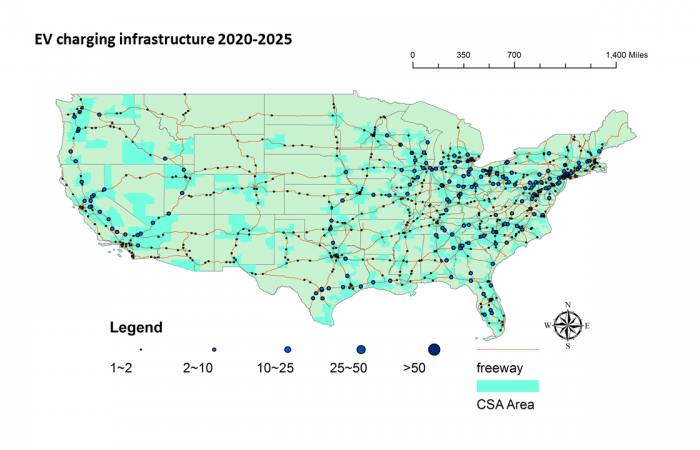
These maps illustrate an estimate of projected EV charging infrastructure buildout through 2025 and 2040, respectively, using the REVISE-II software tool. Credit: Fei Xie/ORNL, U.S. Dept. of Energy
-
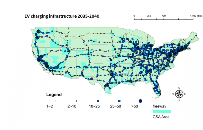
These maps illustrate an estimate of projected EV charging infrastructure buildout through 2025 and 2040, respectively, using the REVISE-II software tool. Credit: Fei Xie/ORNL, U.S. Dept. of Energy
-
The REVISE-II modeling tool developed at ORNL supports decision-making for electric vehicle charging infrastructure development along interstate highways in support of intercity travel. Credit: Jason Richards/ORNL, U.S. Dept. of Energy
-
These maps illustrate an estimate of projected EV charging infrastructure buildout through 2025 and 2040, respectively, using the REVISE-II software tool. Credit: Fei Xie/ORNL, U.S. Dept. of Energy
-
These maps illustrate an estimate of projected EV charging infrastructure buildout through 2025 and 2040, respectively, using the REVISE-II software tool. Credit: Fei Xie/ORNL, U.S. Dept. of Energy
Researchers at Oak Ridge National Laboratory have developed a nationwide modeling tool to help infrastructure planners decide where and when to locate electric vehicle charging stations along interstate highways. The goal is to encourage the adoption of EVs for cross country travel.
The free open-source software, called REVISE-II, takes into account EV growth forecasts, charging technology capabilities, intercity travel trends and driver demographics to help planners fill infrastructure gaps for charging facilities.
By inputting various assumptions, planners can generate scenarios for future charging infrastructure requirements to encourage acceptance of EVs and accommodate growth as more EVs are adopted.
"Providing infrastructure for intercity charging is a necessary step to make EVs fully competitive with conventional vehicles," ORNL's Fei Xie said. "This is a freely available planning tool that takes into account the complexity of intercity travel and helps decisionmakers more carefully plan these capital-intensive projects to support a nationwide, electrified future."


