Observed Oceanic Drivers for the Previous Season
During July-August-September (JAS) 2025, global sea-surface temperature (SST) anomalies remained generally above average, with particularly strong warmth across the extratropical North Pacific.1 In the equatorial Pacific, SSTs near the Date Line (Niño 4 region) cooled, though the seasonal average remained close to normal. Similarly, all other Niño indices showed a cooling tendency, but seasonal averages hovered near-normal. Despite these near-average SST anomalies in the central and eastern equatorial Pacific, coupled ocean-atmosphere signals retained features consistent with a weak La Niña, particularly evident in observed rainfall anomalies (Figure 3, top).
The Indian Ocean Dipole (IOD) index entered a negative phase, primarily driven by above-normal SSTs in the eastern Indian Ocean near Indonesia. SST anomalies in the North Tropical Atlantic (NTA) were above average, while the South Tropical Atlantic (STA) remained close to normal. Above-normal SSTs also persisted across the extratropical North Atlantic.
Outlook for Oceanic Drivers for the Next Season
For November-December-January (NDJ) 2025/26, SST anomalies in the Niño 3.4 and Niño 3 regions are forecast to decline, with the potential transition to a weak La Niña. However, continued above-average SSTs in the western Pacific are expected to sustain a strong east-west SST gradient, reinforcing La Niña-like conditions across the equatorial Pacific.
The Indian Ocean Dipole (IOD) index is projected to remain in its negative phase, supported by persistent warmth in the eastern Indian Ocean near Indonesia. In the equatorial Atlantic, SSTs in the northern tropical region are forecast to remain slightly above-normal, while the southern tropical Atlantic is expected to stay near-normal.
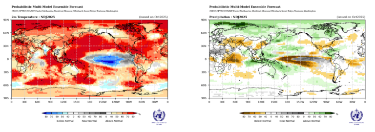
Surface Temperature Outlook for the Next Season
For NDJ 2025/26, the multi-model ensemble forecast indicates a strong global signal for enhanced probabilities of above-normal land surface temperatures, with high model agreement across much of the Northern Hemisphere. Southern and northeastern regions of North America, Central America, the Caribbean, and the Arctic Circle show elevated probability for above-normal conditions, supported by robust model consistency. Small regions lacking a consistent signal include the northwestern part of North America, the interior of the Indian subcontinent, and Southeast Asia.
In the Southern Hemisphere, enhanced probabilities for above-normal temperatures are predicted over New Zealand and southern regions of South America, while most of Australia shows a lack of consistent signal.
In the tropics, strong enhancement in the probability of above-normal temperatures is forecast across equatorial western Africa and the Maritime Continent. These regions also exhibit moderate to strong model agreement, reinforcing the likelihood of persistent warmth.
Over the oceans, widespread above-normal temperatures are projected across the North Pacific, the western Atlantic north of the equator, and the eastern Indian Ocean, with strong model agreement supporting the signal. Elsewhere in the extratropical oceans, the extent of below-normal conditions is limited. Over the equatorial Pacific east of the Date Line, probabilities for below-normal temperatures are enhanced, while the region from 120°W to the coastal waters of South America shows increased probabilities for near-normal conditions.
Rainfall Outlook for the Next Season
The rainfall outlook for NDJ 2025/26 aligns with an enhanced positive east-west sea-surface temperature gradient across the equatorial Pacific, resembling conditions typically observed during a La Niña-even though SST forecasts suggest only a weak La Niña may emerge. Enhanced probabilities for below-normal rainfall are expected to extend eastward from 150°E to just east of the Date Line. North of the equator, this dry signal branches eastward toward the western coast of South America; south of the equator, it extends south-eastward toward the western coastal regions of South America near 35°S. Along the equator, probabilities for near-normal rainfall are forecast from 160°W to the South American coast.
Overall, the NDJ 2025/26 equatorial Pacific rainfall outlook reflects a La Niña-influenced pattern, with suppressed rainfall over the central and eastern Pacific and enhanced rainfall over the western Pacific and adjacent land regions.
Beyond the Pacific basin, enhanced probabilities for below-normal rainfall are predicted over southern Europe extending into Central Asia, interior coastal regions of eastern Asia, coastal areas near the Gulf of Guinea, the Greater Horn of Africa and western Indian Ocean, northeastern Brazil extending into the southern Atlantic, and southern parts of North America. In contrast, probabilities for above-normal rainfall are increased over the southern parts of the Indian subcontinent, northern Asia and the Arctic Circle, Southeast Asia, the Maritime Continent, regions around the Philippines, and the eastern half of Australia, and northern parts of North America.
1 https://www.cpc.ncep.noaa.gov/products/people/mchen/AttributionAnalysis…


