Extreme rainfall from a storm system called Storm Daniel has hit parts of the central and eastern Mediterranean, leading to devastating flooding and loss of life in Libya, the worst affected country, as well as in Greece, Türkiye and Bulgaria.
Up to 10,000 people were reported missing by the Libyan Red Crescent Society, according to the International Federation of Red Cross and Red Crescent Societies. The number of casualties was not immediately confirmed, but hundreds were feared dead.
Libya's National Meteorological Centre said that the storm reached a peak in northeastern Libya on 10 September, with strong winds of 70 - 80 km/h. This caused communications interruption, the fall of electricity towers and trees. Torrential rains of between 150 - 240 mm caused flash floods in several cities, including Al-Bayda, which recorded the highest daily rainfall rate of 414.1 mm (from 10 Sep 8am to 11 Sep 8am)..
The flash floods also led to the death of many residents and great losses of property. Entire neighborhoods in Derna disappeared, along with their residents swept away by water after two ageing dams collapsed making the situation catastrophic and out of control, said the Libyan meteorological service.
The Libyan Government announced three days of mourning in all the affected cities; calling them ″Disaster Areas.″
The National Meteorological Centre issued early warnings for this extreme weather event 72 hours before its occurrence, and notified all governmental authorities by e-mails and through media urging them to take more care and caution, and also urging them to take preventive measures. A State of Emergency was announced in the eastern regions based on these warnings.
The disaster highlights the need for the international Early Warnings for All campaign launched by UN Secretary-General António Guterres. WMO is partnering with the UN Office for Disaster Risk Reduction, the International Telecommunications Union, the IFRC and a range of other partners to ensure that early warnings reach everyone and lead to early action.
As the planet warms, the expectation is that we will see more extreme rainfall events, leading to more severe flooding because warmer air holds more moisture.
Medicane
 Storm Daniel developed in Greece and was named by the Hellenic National Meteorological Service. As it moved towards Libya, Storm Daniel developed the characteristics of a Medicane - MEDIterranean hurriCANE. This hybrid phenomenon shows some characteristics of a tropical cyclone and others of a mid-latitude storm. Activity historically peaks between September and January.
Storm Daniel caused record-breaking rainfall in Greece on 5-6 September, with a reported 750 mm falling in 24 hours at a station in the village of Zagora. This is the equivalent of about 18 months of rainfall. In Thessaly, central Greece, many stations received 400 to 600 mm of rainfall in 24 hours. Thessaly is Greece's agricultural heartland, and so the economic impacts are expected to be serious.
There were a number of fatalities. Many people sought refuge on rooftops.
Concurrently, Greece was battling Europe's biggest ever wildfire, which caused massive destruction in the northeast of the country.
The disasters continue the series of extreme events which have caused loss of livelihoods and lives in many countries around the world in recent months.
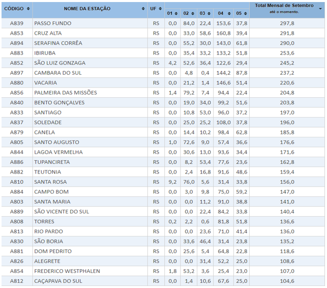
More than thirty people were reported dead after heavy rains and floods from an extra-tropical cyclone hit the Brazilian state of Rio Grande do Sul in the first week of September. On 1st September the Brazilian national weather service issued a press news about the severe weather conditions and high rainfall amounts expected in Rio Grande do Sul. From 1 to 5 September some locations recorded about 250 to 300 mm rainfall, and the September's highest daily values on record were surpassed in some stations on 4 September, such as in Passo Fundo, 164.4 mm (series since 1912) and Cruz Alta 160.8 mm (series since 1913).


