UPDATE: 11am Thursday, October 13
The City of Launceston will close a number of non-critical flood gates along Lindsay Street and behind Inveresk as a precaution, with heavy rainfalls expected later today.
Earlier estimates of 40mm in Launceston overnight failed to materialise, however some areas on the North-West Coast received more than 100mm of rain, prompting several evacuations in the region.
The Weather Bureau is still predicting up to 80mm of rain to fall across Launceston today, however reports of 2016-level flooding across the city have been all-but ruled out.
Council work crews are on standby to assist with any calls for assistance throughout the day.
Meanwhile, several gates behind Hart Street at Newstead may also be closed throughout the day. Council officers letterbox dropped residences in Hart Street with advice on flood safety - again purely as a precaution.
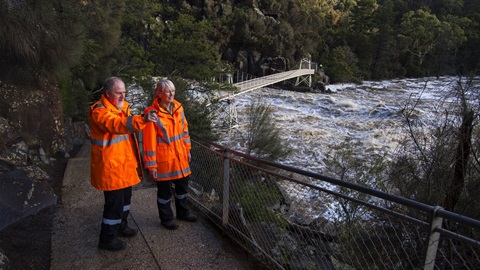
According to the Weather Bureau, strong river level rises are expected along the North Esk River catchment from this morning.
Based on the forecast rainfall, minor flooding may develop along the St Patricks River at Nunamara from late this afternoon.
Minor flooding is likely along the North Esk River at Corra Linn from midday today with moderate flooding possible from late this afternoon.
There is also a minor flood warning in place for the South Esk River between Perth and Longford and around Hadspen and Lake Trevallyn.
FLOOD SAFETY ADVICE:
- SES Flood Warnings can be found at www.TasALERT.com
- Flood and storm safety advice is available at www.ses.tas.gov.au
- Road closure information is available at www.police.tas.gov.au
- For emergency assistance call the SES on telephone number 132 500.
EARLIER:
Northern Tasmania is preparing for a significant weather event over the next 24 to 36 hours, with intense rainfall and damaging winds expected across much of the region.
The Weather Bureau is expecting this weather event to impact the North from tonight, which may lead to flash flooding overnight and into Thursday.
According to forecasts, we could experience six-hourly rainfall totals between 40 and 60mm, with 24 hour rainfalls during Thursday expected to reach 70 to 120mm.
Saturated soils bring an increased risk of gusty winds toppling trees and power-lines, while heavy rainfall increases the potential for landslides and debris across roads.
It is important to stay vigilant if you need to be out and about over the coming 24 hours, particularly in our parks and reserves.
North to north-easterly winds with damaging gusts, peaking up to 95kmh, are possible during Thursday and becoming more likely into Thursday afternoon and evening. Those winds are expected to ease Friday morning.
At this stage, Launceston is likely to experience some flooding from the North Esk River on Thursday evening into Friday morning and the kanamaluka/Tamar Estuary from Friday afternoon and throughout the weekend.
The Council is calling on residents to remain calm and, above all, be prepared.
Our Customer Service team will be open to field calls from 7am Thursday morning.
Council's work crews have been making preparations over the past 24 hours and will be on standby from tonight to assist any members of the public who require help due to flash flooding, which can happen quickly and often without warning.
Remember, in a flash flood, water will rise quickly over a very short period of time.
It's important to be aware of your risk to flooding where you live, have property or work.
There are a number of steps you can take to sure your own safety and that of your family


