Meteorologist, Helen Kirkup, from the Bureau of Meteorology Sydney discusses the NSW forecast for the coming days, which includes:
- A second, stronger cold front will sweep across the state between Friday and Saturday.
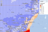
- Damaging winds in the Alpine region will continue. Areas that may be impacted include Snowy Mountains, South Coast, Illawarra, Southern Tablelands, Central Tablelands (including the Blue Mountains) and South West Slopes.
- The wind chill factor from these strong winds will make temperatures feel a lot colder.
- Across the Alpine region a significant amount of snow is expected to fall over the 3 day period.
- During Saturday morning, snow is forecast in the south (SWS such as Tumburumba) above 600m, extending to above 900 metres over the Central Tablelands.
- The combination of snow and strong winds will mean blizzard conditions and low visibility for the alpine peaks and ski resorts.
- Showers about the southern and central western slopes and ranges may be gusty on Thursday and Friday.


