Most people can imagine why a shrinking Great Salt Lake would mean unhealthy dust storms for the Wasatch Front, or why refilling the lake through water conservation could reduce dust exposure. Now, there is a data-based modeling tool to visualize it, hosted at the University of Utah's Wilkes Center for Climate Science & Policy.
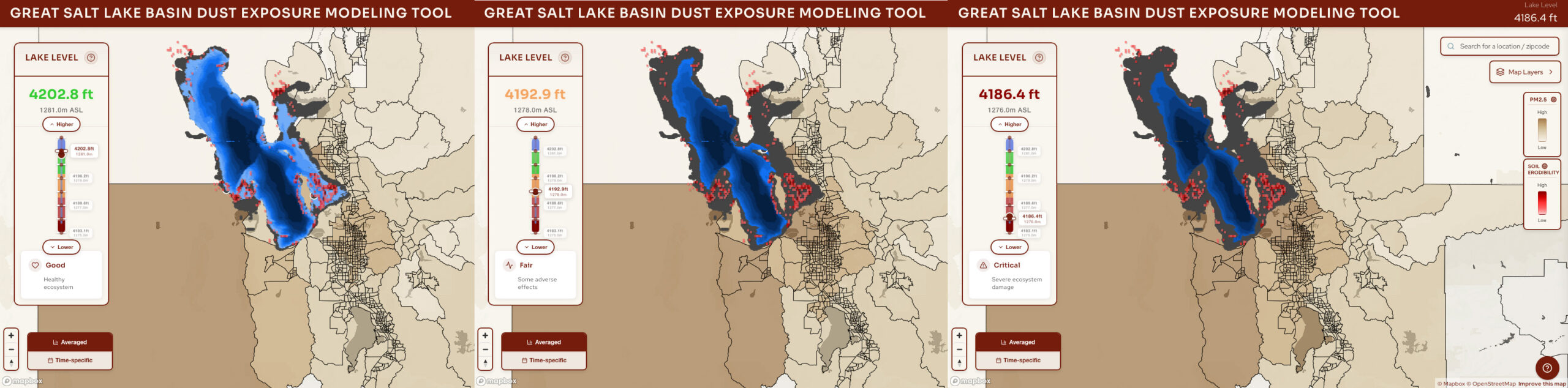
Supported through a project from the state of Utah's Department of Natural Resources, University of Utah atmospheric scientists Derek Mallia and Kevin Perry gathered and produced the data used in the web-based tool. The tool's interactive interface lets users toggle the Great Salt Lake's water levels up or down to see how much lakebed is exposed, and how much dust from the lake is then transported to different communities in northern Utah during dust events.
The tool, and its accompanying storymap, demonstrates why blowing dust from Great Salt Lake is a significant concern, and why lake levels are a major factor in controlling dust. The tool makes the lake's changing bathymetry (the measured water depth of the lake) visually interactive, along with the soil erodibility, affected census tracts, and relevant dust sources that can contribute to unhealthy air quality. Importantly, the tool also quantifies how much dust comes from sources other than the Great Salt Lake-e.g., Sevier Lake, Tule Dry Lake, and the West Desert.
"This data visualization tool demonstrates how the amount of dust that is transported to the surrounding communities is closely tied to the elevation of Great Salt Lake," Perry said. "When lake levels are low, more dust comes off the lakebed. When lake levels are higher, many dust hotspots are submerged and no longer produce dust."
While the current tool is based on spring 2022 PM2.5 data, Malia expects an update soon with sample data of dust events from 2018-2023. He says the additional 5 years of data show that the spring 2022 sample is no anomaly.
"Something our model shows is that even when the lake reaches 'good' levels, PM2.5 levels remain elevated since our model also includes dust from all potential sources across the Great Basin, such as the Sevier Lakebed and West Desert," Malia added.
Mallia and Perry emphasized the tool is a work-in-progress, and will continue to be updated as more data and information becomes available.
"Through the support of the Great Salt Lake Basin Integrated Plan, we are fortunate to have a tool that helps us better understand the origins of dust impacting Wasatch Front communities," said Laura Vernon, Great Salt Lake Basin planner at the Utah Division of Water Resources. "This effort highlights our need to have a comprehensive view of how and when all dust sources, including Great Salt Lake, impact our air quality."
"This Great Salt Lake dust exposure tool puts cutting-edge information from researchers at the University of Utah in the hands of the public and policymakers," said John Lin, the scientific director of the Wilkes Center. "As one of the lead organizations behind the Great Salt Lake Strike Team, the Wilkes Center has been out front in providing data to inform solutions to save the Great Salt Lake."
The Great Salt Lake Strike Team, in its latest 2026 "Data and Insights Summary," has determined that to avoid the worst impacts of dust and other "serious adverse effects," delivering more water to Great Salt Lake is a more cost-effective solution than managing the impacts of a perpetually low-level lake.