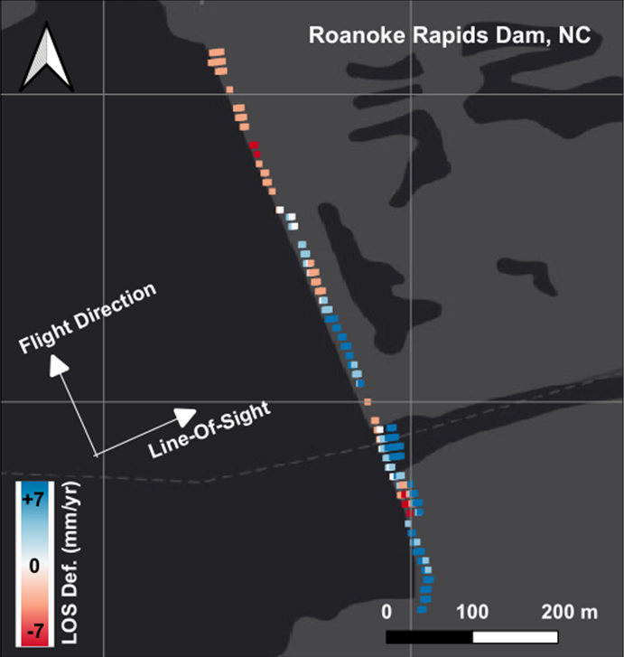
he Roanoke Rapids Dam is a 72 ft. hydropowered dam that sits above-stream of the town of Roanoke Rapids. In the last decade, sections of the dam have sunk into the ground, as revealed by Interferometric Synthetic Aperture Radar, which can be seen in red. Credit: Khorrami et al.
With their newfound ability to inspect dams remotely, Khorrami and his team combined the radar scans with structural data of the dams to understand the risk each dam posed. Overlaying these dams with U.S. Census data, FEMA's National Risk Index, and FEMA's flood inundation zones, they further discovered that many of the most damaged dams are poised to destroy many socially vulnerable communities in the country. These communities may have limited emergency preparedness, with a lack of Emergency Action Plans or resources in the event of a flood.
While the United States has yet to see a massive dam breakage in the modern era, Khorrami's team is hoping to prevent such a tragedy. If any one of these large hydropower dams were to fail, "It's a disaster," said Khorrami.
And not just for the communities inundated with flooding, Shirzaei adds, "Some of the dams actually serve as a sub-buffer for water that's used for agriculture and for electricity production. Those dams can create a ripple effect if they fail that can impact the national economy."
The aging infrastructure in the United States is compounding with a threat the engineers of the 1960's could not have anticipated: climate change. Intensive rain events have begun pushing dams to the brink, forcing them to hold more and more water in much shorter periods of time.
But communities still have a lot of power, Khorrami argues. Referencing a 2025 paper by Nasser et al., he noted that a substantial amount of dam failure is due to a lack of maintenance or poor management. Therefore, "almost 40-50% [of dam risk] is something that is in our hands."
"The next step is to create these dynamic risk models that can be updated on a regular basis using the data that we produce," said Shirzaei. The team intends to build an interactive map with current and future data on US dams at risk, available to the public and policymakers alike.
Contributed by Sierra Bouchér
Abstract information:
Wednesday, 17 December, 11:35 – 11:45 Central Time
Room 294 (NOLA Convention Center)
AGU's Annual Meeting (#AGU25) will bring more than 20,000 Earth and space scientists to the Ernest N. Morial Convention Center in New Orleans, LA from 15-19 December. Members of the press and public information officers can request complimentary press registration for the meeting now through the end of the conference. Learn more about the press AGU25 experience in our online Press Center.
AGU (www.agu.org) is a global community supporting more than half a million professionals and advocates in Earth and space sciences. Through broad and inclusive partnerships, AGU aims to advance discovery and solution science that accelerate knowledge and create solutions that are ethical, unbiased and respectful of communities and their values. Our programs include serving as a scholarly publisher, convening virtual and in-person events and providing career support. We live our values in everything we do, such as our net zero energy renovated building in Washington, D.C. and our Ethics and Equity Center, which fosters a diverse and inclusive geoscience community to ensure responsible conduct.


