
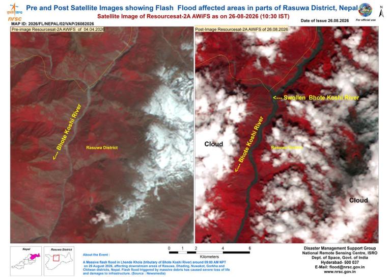
A massive rescue and relief operation has been launched in the wake of devastating flash floods in Nepal, which - according to preliminary reports - were triggered by an avalanche of ice and rocks in the Tibet Autonomous Region of China near the border with Nepal.
Hundreds of people were killed or missing in the disaster on 26 August.
According to the latest situation update from Nepal's National Disaster Risk Reduction and Management Authority (NDRRMA), as of 6:20 p.m. local time on 27 August, 359 bodies had been recovered in connection with the disaster, while 73 people were reported injured. Search and rescue operations remain ongoing, with significant numbers of people still unaccounted for, including foreign tourists.
According to the authorities in Nepal, some 10,000 households are in need of immediate relief. Settlements, markets, roads, bridges and hydropower infrastructure were swept away or damaged, with roads cut off and electricity disrupted.
UN spokesperson Stefan Dujarric said there would clearly be "massive humanitarian need."
Scientists from the International Centre for Integrated Mountain Development (ICIMOD) and partner institutions in Nepal and China are investigating the hypothesis whether the flood may have been triggered by an ice-rock avalanche originating from a high-altitude area near the China/Nepal border.
Preliminary assessment based on video footage and information from affected areas suggest that a large volume of ice and rock debris may have entered the Lende Khola, a tributary of the Bhote Koshi River.
One possibility is that debris temporarily blocked the river at a narrow section, forming a landslide dam and generating a sudden surge that carried water, sediment and large boulders downstream.
Close the gaps in the warning chain
"WMO sends condolences to the victims of the terrible disaster and expresses its solidarity with the communities affected by this devastating flood," said WMO Secretary-General Celeste Saulo.
"The Rasuwa flood highlights the growing challenge posed by cascading hazards in high-mountain regions, where changes and instabilities in the cryosphere can rapidly translate into destructive downstream impacts across national borders. The event underscores why we need to close gaps across the warning value chain - from sustained monitoring and timely detection of emerging hazards, to resilient observing networks, the integration of satellite, in situ, meteorological and hydrological information, and rapid exchange of data across borders," she said.
"WMO is committed to working with its Members and partners so that emerging risks can be detected earlier and translated into timely, actionable warnings for downstream communities," she said.
Hydrological observations indicate the exceptional speed and magnitude of the flood wave. Water levels on the Trishuli River at Galchchi reportedly rose by as much as nine metres within 30 minutes, while levels at Malekhu increased by seven metres over a similar period, according to ICIMOD. This demonstrates how little time communities may have to act when mountain hazards cascade rapidly into downstream flooding.
Several water monitoring stations along the Trishuli River were reportedly damaged or washed away during the event, although the Glachchi monitoring station remains operational.
Compounding the disaster, Nepal has experienced persistent heavy rainfall over the past ten days.
The Bagmati Province - the site of the disaster - can expect frequent rain, and due to orographic lift along the southern foothills of the Himalayas, localized heavy rain or intense downpours will occur, according to the World Meteorological Centre Beijing , which warned that the rainfall intensity will be relatively stronger on the 29 August.
"Precautions are needed to guard against potential secondary disasters such as flash floods, landslides, and debris flows triggered by the persistent heavy precipitation," it said.
Glacial Lake Outburst Flows
Rising temperatures are altering glaciers, snow conditions, permafrost and mountain slopes across the Hindu Kush Himalaya and increasing the risk of Glacial-Lake Outburst Floods.
As temperatures rise, new lakes form, existing ones expand and sometimes merge, increasing the potential flood volumes in the high mountains.
In 2018, ICIMOD released a report on the status of glacial lakes in the HKH that mapped and classified more than 25,000 glacial lakes in the five major river basins spread across the region.
WMO will continue working with its Members and partners, including ICIMOD, to strengthen these connections across the Hindu Kush Himalaya.
Closing the substantial observation and early-warning gaps in vulnerable mountain regions requires sustained investment. Financing mechanisms such as the Systematic Observations Financing Facility and the WMO Commons can help strengthen the foundational observing, data-exchange and prediction systems on which effective warnings depend.


