
Nepal has been hit by yet another major flood, highlighting the need for coordinated action to tackle complex risks from multiple hazards in high mountain areas.
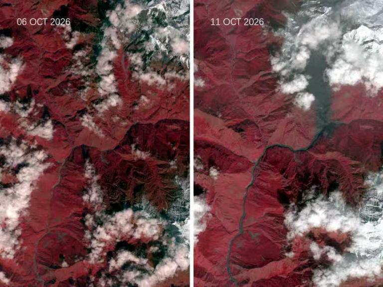
The failure of a temporary river blockage created by a landslide may have triggered the flash flood which swept through the Budhi Gandaki river system in central Nepal on 11 October, according to preliminary accounts from Nepal's authorities reviewed by the International Centre for Integrated Mountain Development (ICIMOD).
"Coming so soon after the Gyirong-Rasuwa disaster, this event is another reminder of how exposed mountain communities and river corridors remain to sudden, cascading hazards," said Pema Gyamtsho, Director General of ICIMOD in a statement. "While response efforts must remain the immediate priority, understanding what triggered this flood will be critical for reducing future risks and strengthening resilience."
Authorities issued warnings for communities along the river systems. According to initial reports, there are a number of missing people, as well as considerable damage to houses, bridges and hydropower infrastructure.
Cryosphere changes increase hazards
The latest flood comes as Nepal is struggling to recover from the events of 26 August, when a huge mass of rock and glacier ice detached from the mountainside at an elevation of 5,200 meters and plunged to the valley floor, triggering an enormous flood of water and debris down the Lhende river and the Bhote Koshi system. It destroyed entire mountain communities, with massive loss of life.
Changes in the cryosphere - glacier retreat and the thawing of mountain permafrost - and structural destabilization from a powerful earthquake more than 10 years ago are factors that likely contributed to the slope instability. Unusually high temperatures before the collapse may have increased melting and the proportion of precipitation falling as rain rather than snow may also have played a role, according to experts at a webinar on 7 October.
The Associated Programme on Flood Management - a joint programme of WMO and the Global Water Partnership Organisation - hosted the webinar Cascading Flood Risks in Mountain Regions: Early Warning, Governance and Resilience . It brought together experts from mountain countries to share lessons and examine how countries can better prepare for and manage evolving hazards.
The risks are unfolding as high-altitude environments undergo rapid change. The WMO's State of Global Water Resources 2025 report found that all glaciated regions worldwide recorded net ice loss for the fourth consecutive year in 2025.
Opening the webinar, Anjali Lohani, global head of water and climate resilience investment at the Global Water Partnership Organisation stressed the need to link preparedness with investment planning and climate finance to try to ensure that monitoring, warning and preparedness systems can keep pace with changing risks.
As glaciers retreat and high-mountain environments change, mountain hazards become increasingly complex, requiring better monitoring, forecasting, early warnings and preparedness, said Narelle van der Wel, head of WMO's Cryosphere Monitoring, Predictions and Services Unit.
Early warnings and early action
Countries in the Hindu Kush Himalaya region have made progress in saving lives through better community-based and model-based flood early warnings. This includes Nepal, which has improved its hydrological monitoring and prediction of riverine and flash floods.
Bibhuti Pokharel, senior divisional meteorologist at Nepal's Department of Hydrology and Meteorology, explained how limited observation infrastructure complicates the detection and prediction of sudden hazards in remote areas.
Nepal's Department of Hydrology and Meteorology issued SMS warnings during the Bhote Koshi flood. But many people doubted the severity of the warnings because they had never experienced a flood like it. Some even went to flood-prone areas to take photographs and videos. Many people did not have time to act, such was the magnitude and speed of the disaster, she said.
"Early warning alone is not enough. It's not enough because saving lives is a joint effort from every sector, coordination among disaster-focused authorities, agencies, local governments, the general public, and forecasters," she said.
Forecasts and early warnings must be disseminated through reliable and trusted sources - starting with the national meteorological and hydrological service. Unverified information from multiple sources - especially in an era when misinformation can spread rapidly and be amplified by AI-generated content - can create confusion, undermine trust and delay action during a disaster, said Bibhuti Pokharel.
In recent years, the region has made progress. The number of recorded disasters in the region rose from 864 between 1986-2005 to 1,148 between 2006-2025. The number of reported deaths fell from 272,085 to 231,470 and injuries from 1.17 million to 0.21 million, said Manish Shrestha, hydrologist at ICIMOD, quoting EM-DAT statistics.
Because rivers and flood risks cross national borders, timely information-sharing and cooperation between upstream and downstream countries is key, he said.
Lessons learned
Other countries face similar challenges and dangers to Nepal.
"The tragedy in Nepal has shown how quickly and destructively such events have developed. Kyrgyzstan is a mountainous country with a large number of glaciers, high-altitude lakes, and permafrost zones, so similar scenarios are possible here," said Daurbek Sakyev, Director of the National Meteorological and Hydrological Services in Kyrgyzstan.
Sakyev highlighted the importance of identifying and monitoring potentially dangerous high-altitude lakes, improving forecasting and modelling, and strengthening the institutional capacity needed to assess and respond to emerging risks.
Christophe Lienert, from the Swiss Federal Office for the Environment, shared lessons of the 2025 ice and rock collapse in the Alpine village of Blatten, namely the importance of a coordinated warning chain that connects science-based information with decisions and early action, supported by sustained and sustainable investment.
Key takeaways
The webinar highlighted several priorities for reducing cascading flood risks in mountain regions, according to Hwirin Kim, chief of WMO Hydrological Modelling and Forecasting section:
- Strengthen monitoring and forecasting: improve high-altitude observations, glacier and permafrost monitoring, real-time data collection, hydrological modelling and multi-hazard early warning systems, particularly in remote areas.
- Turn warnings to action: ensure warnings are timely, reliable, understandable and actionable, with clear communication, evacuation plans, safe shelters and prepared communities.
- Invest in resilience before disaster strikes: secure sustained financing for monitoring networks, early warning systems, community preparedness and resilient infrastructure, linking climate finance and investment planning to ensure that countries can anticipate risks, act on warnings and protect vulnerable communities.
- Improve cross-border cooperation: strengthen data sharing, forecasts and warnings between upstream and downstream communities and countries, recognizing that rivers and cascading hazards do not follow administrative boundaries.
- Early warning is essential, but it cannot prevent disasters on its own: protecting mountain communities requires an integrated approach that combines monitoring and forecasting, with effective governance, community preparedness, cross-border cooperation and sustained investment.


