
Key Takeaways
- The PermitAI™ team at Pacific Northwest National Laboratory has issued two new upgrades to its public resources for searching federal environmental permitting data.
- For the first time in history, public resources covering the full lifecycle of environmental review data are available in one location.
- The new resources make environmental review maps and data findable, accessible and reusable on a national scale.
RICHLAND, Wash.- The PermitAI™ team at the Department of Energy's Pacific Northwest National Laboratory has already revolutionized how federal agencies search past environmental permitting decisions.
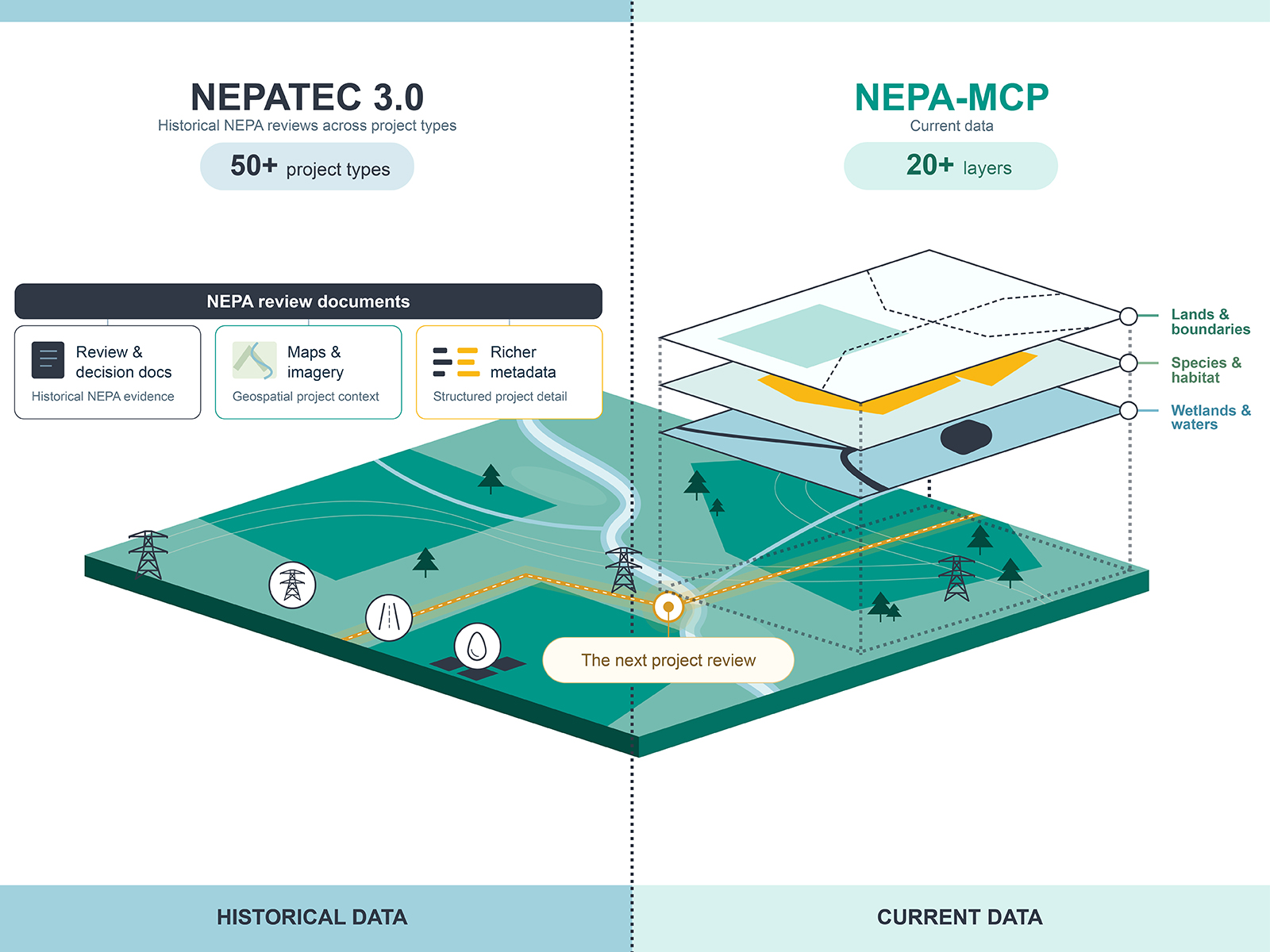
Now it is taking that access one step further with two newly released publicly available resources that give instant access to both past decisions and live government data available in real time. Together, they cover the full federal permitting lifecycle.
The resources include a major upgrade to its National Environmental Policy Act database NEPA Text Corpus (NEPATEC3.0). For the first time, the data include rich visuals, including map imagery and geospatial layers, making it the largest publicly available geo-enriched map repository of NEPA environmental review documents. The GeoAI pipeline behind NEPATEC3.0 produced over 630,000 map images and 135,000 GeoTIFFs, providing a geographically discoverable and reusable dataset.
"Permitting is inherently geospatial," said Anastasia Bernat, a data scientist and technical lead for PermitAI. "Applying GeoAI to this process is already advancing new research in how vision-language models interpret maps and geospatial data. And it has the potential to reshape the pace and precision of permitting decisions nationwide."
In addition, the NEPATEC3.0 database now contains 188,000 documents including more than 30 text and image metadata types. The metadata allows users to group like-data across many different document types for a more robust analysis.
This upgrade represents a significant expansion over earlier versions, which included only text. NEPATEC2.0 contained 140,000 documents and 14 metadata types, and NEPATEC1.0 had 26,000 documents with 5 associated metadata types.
These new enhancements support environmental policy research and analysis, increased understanding of permitting processes, high-level categorization, filtering, integration with other datasets, and rich visualization of project locations to inform the review of future projects.
"Environmental professionals don't just want to read about projects, they need to see their location on a map," said Sai Munikoti, a co-principal investigator of PermitAI and data scientist at PNNL. "Now, that information is available to them."
Instant access to active federal sources
NEPA Model Context Protocol (NEPA-MCP) is a fully open-source toolkit for accessing live one-stop-shop environmental data from more than 20 government sources. It includes live authoritative data for current federal reviews and rich resources for understanding legal jurisdiction, water, wildlife habitat, and other environmental resources for a proposed project area.
Unlike pulling raw data from scattered, isolated locations, NEPA-MCP provides access in a single, easy-to-use interface. Its standardized, richly contextualized information, including geospatial overlays and regulatory context offers access to 23 MCP servers with 56 MCP tools. Each server provides access to a specific federal agency or authoritative data source, ensuring transparent, modular access to agency systems. By enabling ready-to-use live data from multiple sources, NEPA-MCP can unlock new and faster development possibilities.
"We are now at a key inflection point in the development of PermitAI™, where we are ready to deploy our tools and resources in real-world workflows," said Sarthak Chaturvedi, who led the NEPA-MCP project for the PermitAI team. "We have done the important groundwork in developing data standards, metadata and streamlining data connection that allows users to compare relationships among data points to make information easier to understand and reuse. Now it's time to have users come kick the tires and help improve our work."
Partnering for impact
The team has not worked in isolation. Rather, they have engaged with industry leaders to put their work through its paces in agentic and large language model environments.
PermitAI has been working with the federal Council on Environmental Quality (CEQ) to build a standard framework for NEPATEC3.0 as well as to provide data services to CEQ initiatives via NEPA-MCP.
Earlier in 2026, the team reported the results of their collaboration with OpenAI, using coding agents to reduce some of the repetitive and tedious drafting work associated with writing environmental reviews.
Similarly, the team has partnered with PNNL's Center for Continuum Computing and Google to implement data enrichment and storage in the Google Cloud Platform, making data sharing easier.
From experiment to vital resource
PermitAI™ began as a pilot project sponsored by DOE's Office of Policy to centralize NEPA decision data for DOE. Driven by the recent federal priority to accelerate and improve environmental reviews, the team has expanded its focus.
It quickly expanded upon release of America's AI Action Plan and the Council on Environmental Quality's directive for federal agencies to adopt uniform data standards.
For the public, access to the nation's historic and modern permitting decision making documents provides insight into what can, at times, seem like a convoluted process. NEPA review data access can also help demystify potential impacts and mitigation strategies of proposed projects.
PermitAI™ is currently partnering with the Permitting Council to expand the reach of its suite of data resources and toolkits.
To stay up to date on PermitAI™, subscribe to the PermitAI™ newsletter.


