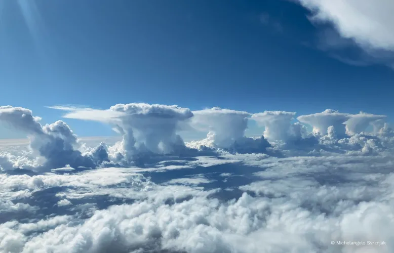
Thunderstorms, east-south-east of Perth, Western Australia. Credit: Michelangelo Svrznjak.
A bird's eye view of a line of thunderstorms in Western Australia, captured from the flight deck of a plane, is featured in the November photo in the 2026 Australian Weather Calendar.
For seasoned airline pilot Michelangelo Svrznjak, who snapped the photo, seeing storm clouds and other weather features from the windscreen of the plane is a regular feature of his job.
But this line-up of such distinct thunderstorms was different - an unusual sight he described as "unbelievable".
"I've seen isolated storms, and we go around them all the time, it's nothing new," Michelangelo said.
"But to see them formed perfectly, almost equally distant from each other, was pretty awesome.
"It's the first and probably the last time I'll ever see something like that.
"It was just the strangest fluke."
This line of storms provides a visual marker for a west coast trough, observed near the coastline of Western Australia.
Forming during warmer months, the west coast trough is a zone of low pressure that develops at the boundary between warm continental easterly winds driven by the sub-tropical ridge to the south, and cooler westerly maritime air from the Indian Ocean.
The warm and cool winds collide in the atmosphere and are forced upwards, resulting in a line of showers and thunderstorms.
Many locations across Australia feel the impact of the west coast trough.
Areas to the east can experience hot days with temperatures above 40 °C, and the possibility of thunderstorms if atmospheric moisture is sufficient.
To the west of the trough, milder conditions with sea breezes generally prevail.
Pilots always take the forecast before and during flights into account, Michelangelo said.
"That's the most important thing we look at, what is happening with the weather, not just at your destination, but at your origin and locations enroute that you're using as an alternate airport in case you need to go somewhere," he said.
"The first thing we look at is what is the weather doing.
"Everything else, we can manage it on the day; passengers and delays and things like that."
To support a smooth ride, the Bureau provides turbulence forecasts, weather charts and other guidance for pilots and airport ground staff through its Aviation Meteorological Services.
Order your copy of the 2026 Australian Weather Calendar now at https://shop.bom.gov.au/


