Meteorologist, Jonathan How: Hello from the Bureau; and even though we are in the second month of autumn the tropics are still active, and it's off the northwest of the Top End where we're currently monitoring a tropical low.
The latest satellite shows thick cloud and thunderstorm activity associated with the low, just off the Tiwi Islands.
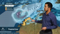
The low is expected to continue intensifying and may develop into Australia's eighth cyclone of the season as early as Friday, or during Saturday.
If it does, the next name on the list is Wallace. Until then, a severe weather warning is current across the north-west Top End, including Darwin and the Tiwi Islands, for damaging winds and heavy rainfall leading to flash flooding.
We're already seeing heavy rain develop around the system, and some coastal communities across the Cobourg Peninsula and Tiwis may see daily totals in excess of 150mm, with wind gusts to 100km/h reaching further south into the Daly and northwest Arnhem districts.
At this stage, the tropical system is not expected to impact land areas of the Northern Territory at cyclone strength.
However, it may have impacts on some northern coastal locations of Western Australia from as early as tomorrow.
As such, a cyclone Watch has been issued for communities between Kalumburu and Cockatoo Island.
And people within this area may see gales develop from late Friday or during Saturday.
The system is then likely to move in a south-westerly direction through the weekend, and although this computer model scenario keeps it offshore in the short term, there is the potential for it to approach the Pilbara coast early next week, possibly impacting the same areas that were recently affected by severe tropical cyclone Veronica.
And the grey shading does show the potential track this system could take.
So if you're across the western Top End or northern WA, please remember stay up to date with any Warnings or Watches over the coming days via the Bureau website, app or social media channels.
And as always, follow all advice from your local emergency services.


