Bureau of Meteorology Senior Meteorologist, Dr Adam Morgan: Hello again, we've seen more extraordinary rainfall over the past 24 hours along the Townsville coast, and there's even more on the way.
This is a high impact, historic event that's unfolding – with inundation of homes, flood water rescues, land slides and trees down.
Here are the current warnings.
A severe weather warning covers communities including Tully, Cardwell, Ingham and Townsville.
People in this area should prepare for bands of very heavy rainfall and thunderstorms throughout today, which are likely to result is flash flooding.
Any flooding that does develop will do so quickly, with the ground already saturated and creeks and rivers already swollen.
Earlier this morning we saw 193 mm in just 6 hours at Major Creek, and we expect to see further 6-hour totals in that 150-200 mm range continue today.
A host of flood warnings are in place across the region, including major flood warnings for the Bohle River, Haughton River, and Herbert River.
The Ross River Dam continues to spill, and we may see the Ross River reach moderate flood levels later today.
A flood watch remains current in anticipation of the further flooding.
Across the region, 24 hour rainfall to 9 am was broadly in the range 100 to 200 mm, with several spots registering totals of between 200 and 300 mm.
The highest was 376 mm at Upper Bluewater to the west of Townsville.
At Bluewater itself, we recorded 203 mm of rain in just 2 hours – this rainfall intensity is something we'd expect to see on average only one in around 100 years.
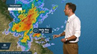
The rain is still falling, and since 9 am this morning the highest totals have been again around Townsville, with 97 mm at Nelly Bay up to midday, the highest.
Today, the rain will extend further east towards Bowen and Proserpine…
And then overnight and on Friday we expect those heavy rain areas to extend up along the coast towards Innisfail, as the strengthening monsoon trough gradually shifts a little to the north.
This is likely to be a protracted period of heavy rain extending through the weekend and into next week.
Already 700 to 1000 mm – yes, a metre – of rain has fallen across the region over the past 5 days.
Townsville has seen double its usual rainfall for January, and is now already almost half way towards the total rainfall it would usually see in a whole year.
And over the coming week it's possible that the region around Townsville and the Herbert and Lower Burdekin district could see an additional 1 to 2 metres.
River flooding is likely to get worse, before it gets better, and remember…. If it's flooded, forget it.
And please, follow all advice from emergency services.
Warnings will be updated regularly as the rain continues to fall, so stay tuned to the Bureau on our website, app and on social media.


