
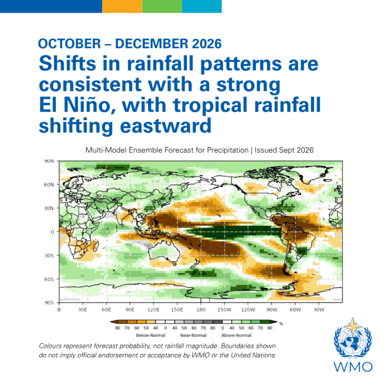
World Food Day takes place on 16 October against a backdrop of an intensifying El Niño which is driving significant shifts in rainfall patterns - from drought to deluge - and impacting agriculture, fisheries and food production.
Farmers - just like energy and water managers, disaster responders and health professionals - are among the many who are asking how this climate phenomenon will affect them.
The WMO community has stepped up the flow of information and services to agriculture and other climate sensitive sectors. This includes through products like the quarterly El Niño Updates , the monthly Global Seasonal Climate Outlook and the tailored Global Seasonal Outlook provided by WMO Coordination Mechanism for the humanitarian sector. Regional Climate Outlook Forums issue regionally-specific information, and National Meteorological and Hydrological Services are responsible for country-level forecasts and expertise.
El Niño means "boy child" in Spanish and was named by Peruvian fishermen who noticed a reduction in their anchovy catches just before Christmas time due to the warming of cold nutrient-rich coastal waters.
"El Niño impacts vary from one region to another and often even within the same region, and also from season to season. Existing environmental conditions, seasonal rainfall cycles and other climate drivers also shape the outcome," says Wilfran Moufouma Okia, chief of Climate Prediction Section at WMO
Different places. Different seasons. Different impacts.
The Greater Horn of Africa illustrates this perfectly.
A seasonal outlook issued by the IGAD Climate Prediction and Applications Centre (ICPAC) in May forecast below-normal rainfall during the June-September 2026 season across northern parts of the region, particularly in parts of Ethiopia, South Sudan and Sudan. And according to latest data from ICPAC, rainfall deficits persisted across much of this sector during the season, resulting in soil moisture deficits and vegetation stress emerging, both indicative of negative outcomes for crops and pasture.
This is a critical agricultural season, providing around 60% of annual rainfall in some areas. Since parts of these countries are already facing severe food insecurity, the occurrence of reduced rainfall could increase humanitarian needs.
Yet elsewhere in the same region, the story is different.
Fast-forward to a new seasonal outlook, issued by ICPAC on 19 August , which forecast wetter-than normal conditions for the equatorial and southern parts of the Greater Horn of Africa during the October to December rains.
Up to 70% of total annual rainfall in parts of Ethiopia, Kenya and Somalia and up to 40% of total annual rainfall in parts of Rwanda, Burundi, Tanzania and Uganda falls in the October-December season.
The seasonal outlook is welcome news for pasture and water availability for livestock and crops. However, excessive rainfall substantially increases the risk of flooding, landslides, infrastructure damage, disease outbreaks and agricultural losses.
"At different times of the year, the same climate phenomenon therefore increases drought risk in one part of the region while increasing flood risk in another, sometimes with similar and compounding impacts on sectors like agriculture," says WMO scientific officer Sebastian Grey.
South Asia tells a similar story.
The June-September monsoon supplies the rainfall needed for staple crops such as rice across much of the region. Forecasts issued through the South Asian Climate Outlook Forum (SASCOF) correctly predicted an increased likelihood of below-normal rainfall this season, with observations already showing significant rainfall deficits in several areas. This raises concerns for agriculture, water resources and food security. Rainfall deficits have been subsequently experienced in parts of India; however, impacts on yields of key crops are not yet known.
The October-December rainfall season is more important for southern parts of South Asia - specifically southern India, Sri Lanka, and Maldives -and agricultural operations depend on this season. Normal to above-normal rainfall during October-December is likely over northwestern and parts of eastern and southern South Asia, including the island nations. Below-normal rainfall is likely over most parts of central and southern peninsular South Asia and some parts of eastern South Asia.
Drought is currently a major concern over a vast swathe of southeast Asia.
South America also experiences contrasting impacts.
Northern Brazil typically becomes drier than normal during El Niño events, while southern Brazil often experiences above-normal rainfall during the September-January period.
Chile has seen exceptionally heavy rainfall, causing the normally arid Atacama desert to bloom, and bringing disruptive flooding.
The Atlantic hurricane season has been exceptionally quiet - sparing farmers from the fury of winds and floods. However, during the transition out of the Caribbean Wet and Heat Seasons, a very strong El Niño could mean an expansion of drought conditions, with impacts on agriculture and water availability.
The Pacific, by contrast, has seen very high tropical cyclone activity, fuelled by warm waters. Hurricane Trudy was intensifying on 16 October as it headed towards the Mexican coast - the latest in a series of hurricanes which pose a risk to fisheries, agricultural production and the transport of farm and food commodities.
Higher than normal temperatures
Sea-surface temperatures in the central and eastern tropical Pacific are forecast to increase to record levels during October-November-December 2026.
Rising ocean heat is causing concern for the fisheries sector, not just in Peru where anchoveta fishing has been suspended to protect stocks, but throughout the Pacific, with the risk of marine heatwaves and severe coral bleaching, raising concern not only over environmental impacts but also over impacts on income for fishing communities and the fishing industry more broadly.
El Niño will add extra heat to an already warming climate. The past eleven years have been the warmest on record, meaning that El Niño now amplifies temperatures against a much higher baseline.
The consequences extend well beyond uncomfortable weather.
The joint FAO-WMO report on Extreme Heat and Agriculture shows that increasing temperatures and more frequent heatwaves are reducing crop yields, increasing the number of unsafe working hours for agricultural labourers, stressing livestock, and contributing to marine heatwaves that affect fisheries and marine ecosystems.
"Even warmer winters can have important agricultural consequences. For crops such as wheat, unusually high winter and spring temperatures can increase water demand, accelerate crop development and reduce grain yields if heat occurs during sensitive growth stages," says WMO's Sebastian Grey.
From science to services
WMO and its global network of 193 National Meteorological and Hydrological Services (NMHSs) and Regional Climate Centres are working together to protect food security and farm and fishing livelihoods through authoritative seasonal outlooks and national forecasts.
These translate climate science into practical information that governments, humanitarian organisations, businesses and communities can use: a farmer deciding when to plant; a humanitarian agency preparing emergency assistance, a government planning water management.


