Large swathes of North America have been gripped by cold and heavy snowfall, causing loss of life, major traffic chaos and power outages for millions of people.
The prolonged freeze, which saw many new record cold maximum and minimum temperatures, was caused by an Arctic blast of air moving down from Canada all the way into Texas.

More than 100 million people over 1.6 million km² were under winter storm warnings, according to the US National Weather Service. Some 73% of the Continental USA was covered in snow as of midnight February 16, the greatest extent on record in the database, which dates back to 2003.
Some parts of Texas were colder than Alaska. According to news reports, Dallas reached a low of 4°F (-16°C) on February 15, the coldest temperature the city has seen since 1989. Temperatures near 60°F (15.6°C) are more typical this time of year. The temperature at Houston's Intercontinental Airport was 17°F (-8°C).
A reported 4 million people in Texas were without power. Satellite data published by NASA showed the extent of the power outages as the state was plunged into darkness.
The US National Weather Service said that abnormally cold temperatures would continue until 19 February. "Record cold daily maximum and minimum temperatures are likely to transpire in the South Central U.S. through Saturday morning. The Plains and Mississippi Valley can expect daily temperature anomalies ranging between 20 and 30 degrees Fahrenheit below normal," it said.
Storms and cold in Europe
 The Russian Federation and Northern parts of Europe were hit by very cold weather in mid-February, alongside a series of Atlantic storms. Southern Europe and the Mediterranean saw major snowstorms, including in Spain. Greece was blanketed by snow in the week of 15 February and snow added to the humanitarian woes of populations in Syria and Yemen.
The United Kingdom saw its coldest February night since 1955, with the temperature in Braemar, Aberdeenshire fell to minus 23.0 °C on 10 February, according to the UK's Met Office.
In Scandinavia, Latvia saw an average air temperature in winter 2020/2021 of -3,7 °C, the coldest since 2012/2013, and also with the thickest snow cover since then. In the first ten days of February the average air temperature in Latvia was -8.8 °C, which is 5.0 °C below the decade norm (1981-2010 norm).
In Germany, in the week beginning 8 February, the temperature fell below -20°C at many observing stations, breaking monthly records, whilst even low-lying areas received heavy snow, according to the Deutsche Wetterdienst. Canals in the Netherlands froze over - an increasingly rare event.
Sudden Stratospheric Warming
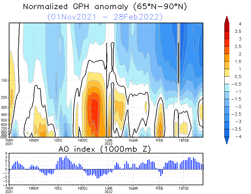
February's extreme weather was triggered by large scale and interconnected atmospheric circulation patterns and a recent meteorological event called a Sudden Stratospheric Warming Event high up in the Stratosphere, about 30 km over the North Pole.

The stratospheric warming event led to a weakening of the polar vortex, which is an area of low pressure and cold air surrounding the Earth's North and South poles, with swirling westerly jet stream winds circulating around them. Typically, those winds are strong enough to keep the coldest air in the Arctic during the winter. The weakening allowed the cold air to spill out into the mid-latitudes, including the USA, and for the warmer air to enter the Arctic.
An index called the Arctic Oscillation measures the extent to which polar air is either held back in the Arctic or meanders southwards. A positive Arctic Oscillation indicates cold air is trapped in the Arctic; and a negative one means that cold air crashes south as the jet stream weakens.
Repeated disruptions of the polar vortex resulted in a strongly negative Arctic oscillation since early December 2020. This translated into a warm Arctic, cold continent pattern, with cold waves in Europe, as well as episodes of heavy precipitation particularly over southern Europe and the Mediterranean rim countries, and Atlantic storms.
Role of Climate Change
The cold spell is unusual but not exceptional. And in contrast to North America, other parts of the globe have been unusually warm. Following the cold spell, many parts of central Europe became unseasonably warm.
 In general, cold waves are becoming more infrequent as a result of climate change and there has been a decline in new cold temperature records as a result of global warming. But frigid temperatures and snow will continue to be part of our typical weather patterns in the northern hemisphere winter.
In its Fifth Assessment Report, the Intergovernmental Panel on Climate Change said it is "virtually certain that there will be more frequent hot and fewer cold temperature extremes over most land areas on daily and seasonal timescales as global mean temperatures increase. It is very likely that heat waves will occur with a higher frequency and duration. Occasional cold winter extremes will continue to occur."
Research is still ongoing on the attribution of extreme temperatures (cold and warm events) observed occasionally in the northern hemisphere winter season. Of particular interest is the question of how the uneven distribution of warming between higher and lower latitudes - with climate warming at greater rate in the polar regions-, could explain or interact with some of these types of short-term intra-seasonal variability.


