For the first time, a tropical mass flowering of various tree species was viewed from space using satellite technology. The satellite imagery was analyzed by an international team led by researchers from the University of Hawaiʻi at Mānoa.
The team consisted of Tomoaki Miura from UH Mānoa's College of Tropical Agriculture and Human Resources (CTAHR) Department of Natural Resources and Environmental Management, along with scientists from the Japan Agency for Marine-Earth Science and Technology, Miyazaki University, University of Zurich, Yokohama City University, Sarawak Forestry Department and Kochi University.
From its base in Lambir Hills National Park, located in the Malaysia part of Borneo, the team witnessed a mass flowering, or general flowering, of trees in tropical rainforests in Borneo and Southeast Asia in 2019.
"Trees in tropical rainforests in Borneo and Southeast Asia region do not flower annually, and sometimes they do not flower for many years," said Miura. "When they flower, a large number of various tree species flower all at once during a period of a few weeks to a few months, which is followed by mass fruiting."
Using satellite technology to monitor tropical forest ecosystems
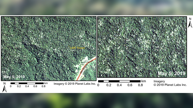
The UH Mānoa-led team was able to view the event from space using PlanetScope CubeSats, a class of nanosatellite technology, that revealed the spatial extent of this phenomenon by capturing individual flowering trees. They leveraged this new technology to obtain many cloud-free, high-quality images far above the national park.
By analyzing the satellite imagery, the researchers found that the 2019 general flowering event occurred throughout the entire park. They noticed that flowering trees could only be seen in elevations ranging from 50 to 300 meters. They also found that most trees flowered in the month of May, but some flowered in April or June, which was directly linked to the species of trees.
"These findings should help improve our ability to monitor general flowering and our understanding of the functioning of the tropical forest ecosystem," said Miura. "CubeSat technology and the approach used in this study have the potential to monitor noxious weeds and invasive trees that bear distinctive flowers, such as fireweeds and African tulip trees, which should be a useful tool for management of these plants."
The study, "Utility of commercial high resolution satellite imagery for monitoring general flowering in Sarawak, Borneo," appears in the February 2023 edition of Ecological Research. The study's authors are Miura, Yuji Tokumoto, Nagai Shin, Kentaro K. Shimizu, Runi anak Sylvester Punnga and Tomoaki Ichie.


