High intensity heatwave conditions will return to major population centres in New South Wales and the ACT from tomorrow (Thursday), with the worst impacts likely to be felt in many areas on Australia Day.
"From Thursday temperatures will again climb sharply, and unfortunately for many areas in the east, peak temperatures will probably hit on Saturday and Sunday," Bureau of Meteorology NSW/ACT Manager of Weather Services, Jane Golding said.
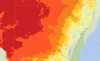
On current forecasts, by Australia Day Severe Heatwave conditions will be impacting the ACT and large areas of central New South Wales.
Temperatures in western Sydney are likely to be very close to the 40 degree mark, Canberra is expected to be similar and western NSW will see most locations hit the mid 40's, and some go higher. A sea breeze should keep Sydney and much of the coastal fringe in the low-30's, however that is likely to be accompanied by very high humidity.
"We saw clearly from last week's heatwave the impacts of this sort of weather on peoples' health, when you combine that with a weekend of major outdoor events and the last long weekend for a while there is reason for some concern," Ms Golding cautioned.
This event is broadly similar to last week's heatwave, albeit with localised differences. Already this week daytime maximum temperatures on Tuesday were close to 45 degrees over large parts of western NSW, while temperatures did not drop below 27 degrees for many of those locations on Monday and Tuesday nights. Some, including Bourke, Tibooburra and White Cliffs, did not drop below 32 degrees.
The Bureau of Meteorology is working closely with health, emergency services, lifesavers and event organisers to ensure the community is aware of these conditions.
"We are urging people to keep an eye on the forecast over the coming days, so they can plan their days, enjoy whatever they're doing and stay safe at the same time," Ms Golding added.
The current conditions will also see elevated fire dangers over coming days and could trigger thunderstorms in some areas.


