More than one million high-resolution images from 860 of the world's coral reefs have been made available to scientists by The University of Queensland and ocean conservation non-profit, Underwater Earth.
Project leader UQ's Professor Ove Hoegh-Guldberg said the research and images were integral to better protecting the world's reefs.
"Coral reefs provide food and livelihoods for hundreds of millions of people globally and are home to thousands of species," Professor Hoegh-Guldberg said.
"Yet coral reefs have been severely impacted by climate change, poor land management practices, pollution and invasive species.
"Urgent conservation action is required to protect these reefs from the impact of climate change and local factors such as pollution and over-fishing."
Professor Hoegh-Guldberg said research is required to better understand how coral reefs are responding to these pressures and to identify management options for mitigating these impacts and restoring degraded coral reefs.
 "A key obstacle to managing coral reefs is being able to detect how coral reefs are changing, which requires having an appropriate baseline," he said.
"Our project developed new technologies for rapidly surveying coral reefs, which improves our ability to determine the condition and composition of reefs, allowing us to better understand how reefs are being impacted by human activities."
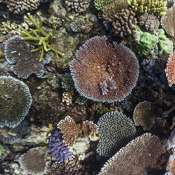
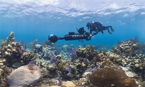
The XL Catlin Seaview Survey images were collected with a custom camera system developed by Underwater Earth.
A typical survey dive would collect 1500 high-resolution images, and there were often several dives per day.
Lead researcher Dr Manuel González-Rivero said processing the images was far from straightforward.
"It's not feasible to interpret this number of images manually, so we had to develop machine-learning techniques to classify and analyse the images," Dr González-Rivero said.
"The million-plus image database includes all of the information needed to train and evaluate machine-learning methods, so is of value to both coral reef ecology and computer-science applications.
"This technology is bolstering reef science, hopefully helping shape policy and protecting coral reefs for generations to come."
Chip Cunliffe, Sustainable Development Director at AXA XL (formerly XL Catlin) said it was important that the images are freely available to scientists.
"The significance of the Seaview Survey baseline has become even more evident over the past few years," Mr Cunliffe said.
"Ensuring scientists have unrestricted access to this data is crucial to both our collective understanding and future management of these vitally important ecosystems."
Further information on the surveys and access to the data is available through The University of Queensland data repository.
The project was supported by XL Catlin (now AXA XL), with additional support from Vulcan Inc., Academia Sinica, and the Australian Government.
Images: above- An example of a survey image that can be analysed using artificial intelligence methods to identify the types of corals present. © The University of Queensland / Underwater Earth / XL Catlin Seaview Survey: right - Dr. Manuel González-Rivero piloting the SVII camera system. © Underwater Earth / XL Catlin Seaview Survey / Christophe Bailhache


