Meteorology is a global science
Sharing knowledge and expertise benefits all nations, including Australia.
We contribute to this global effort, working with organisations around the world. Our expertise helps advance international science, technology and operations.
Satellite observations are critical to our day‑to‑day work.
Satellites provide more than 90% of the data used in our weather and climate models. We use data from around 30 geostationary and polar-orbiting satellites, and all are operated by international partners. Observations from these satellites provides vital situational awareness that enhances forecast accuracy and timeliness. Continued collaboration is essential to maintaining the quality and reliability of our services.
Part of our role as the Permanent Representative for Australia in the World Meteorological Organization (WMO) is to coordinate and support regional programs and activities, such as the annual Asia-Oceania Meteorological Satellite User Conference (AOMSUC).
AOMSUC is a unique forum for international space and weather agencies to exchange ideas. These relationships are key to keeping the bureau at the forefront of satellite meteorology. International collaboration plays a vital role in:
- improving weather and climate modelling
- enhancing disaster monitoring and response
- supporting aviation, marine and defence services
- building resilience to increasing high risk weather events.
Harnessing bright minds to create real-world benefits
The conference brings together meteorologists, satellite operators and researchers from across the region. Participants will share knowledge, strengthen partnerships and advance the use of satellite data for weather, climate and disaster services.
The conference has 3 events: training for participants from the Asia-Oceania region, technical presentations from satellite operators and satellite data users, and a meeting for WMO regional members to share the latest information on how they use satellite data for forecasts and warnings.
Across all the week participants will explore:
- the latest training from the bureau's VLab Centre of Excellence
- new developments in satellite technology and data assimilation
- practical applications of satellite data for severe weather and hazards
- opportunities for future regional and international collaboration.
Previous conferences have delivered tangible benefits. A collaborative initiative with the Japan Meteorological Agency (JMA) which began at AOMSUC-10 will see real-time Himawari satellite imagery helping forecasters track bushfire outbreaks and issue warnings to ground crews faster.
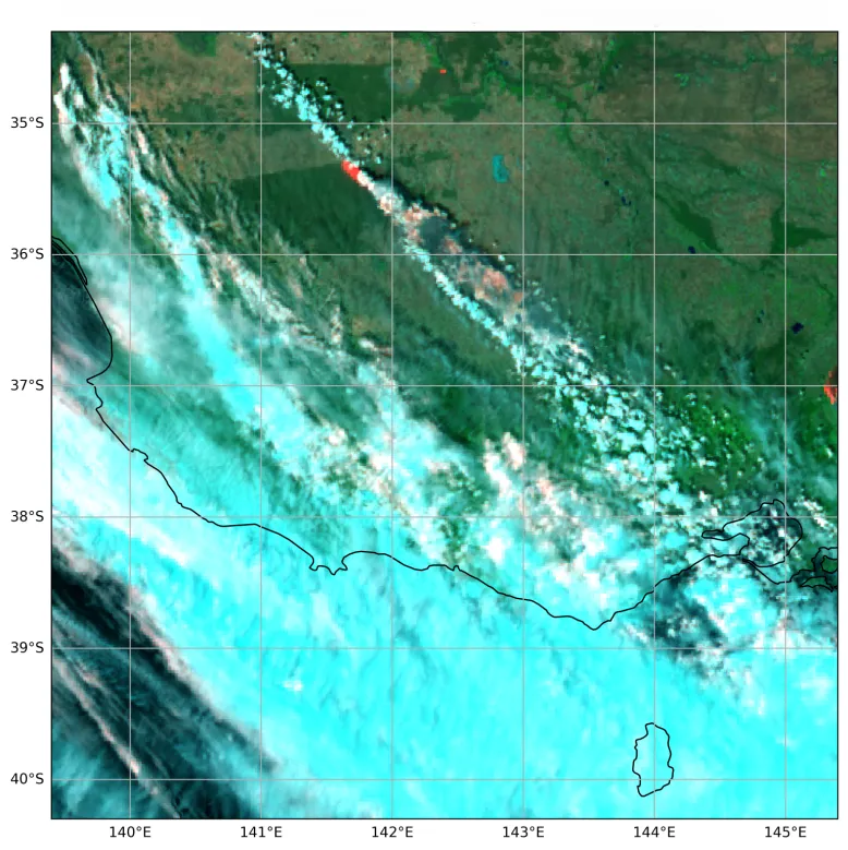
Himawari satellite image taken on 9 January 2026 during the Grampians (Gariwerd) National Park bushfires in Victoria. The image has been colour-enhanced to highlight specific meteorological features. Active fires appear in shades of red and smoke in shades of blue. During active emergencies JMA can provide these images every 2.5 minutes.
Supporting developing countries
The Bureau of Meteorology together with WMO will sponsor up to 20 participants from developing countries to attend the event. This support aims to bridge the research gap, foster international collaboration and enhance the capability of scientists and researchers in developing countries.
Coordinating and building capacity across nations means better weather forecasts for everyone. It also delivers economic, social, safety and security benefits.


