Key takeaways
- The Earth Dynamics Geodetic Explorer, or EDGE, will map the Earth's topography, vegetation, ice and coastal regions with unprecedented 3D detail.
- Set to launch in 2030, the new satellite will provide scientists with a detailed look at how the texture of the Earth's surface is changing, from where ice caps are melting to how forests are removing carbon from the atmosphere.
- Chris Hakkenberg, from UCLA's Department of Geography, will co-lead biodiversity and habitat mapping efforts across the planet's forests.
As NASA celebrates its historic Artemis II mission, it's also turning its attention to Earth, and a special project UCLA has become a part of.
The Earth Dynamics Geodetic Explorer, or EDGE, is a new satellite project from the U.S. space agency, UCLA and others, set to map the three-dimensional structure of the Earth's topography, vegetation, ice and coastal regions with unprecedented 3D detail and accuracy.
Chris Hakkenberg, a mission team member and associate researcher in UCLA's Department of Geography, will co-lead biodiversity and habitat mapping efforts across the planet's forests. Hakkenberg would also lead EDGE's wildfire fuels effort if NASA approves the planned wildfire work.
The project, which will see a satellite launched into space in 2030, is led by Helen Fricker, a UC San Diego glaciologist. In collaboration with NASA Goddard Space Flight Center and multiple universities, the EDGE mission will provide researchers with their most detailed view yet of Earth's forests and ice sheets.
With a budget of up to $355 million to develop, launch and maintain EDGE's high-resolution mapping capabilities, the new satellite will provide scientists with a detailed look at how the texture of the Earth's surface is changing, from where ice caps are melting to how forests are removing carbon from the atmosphere.
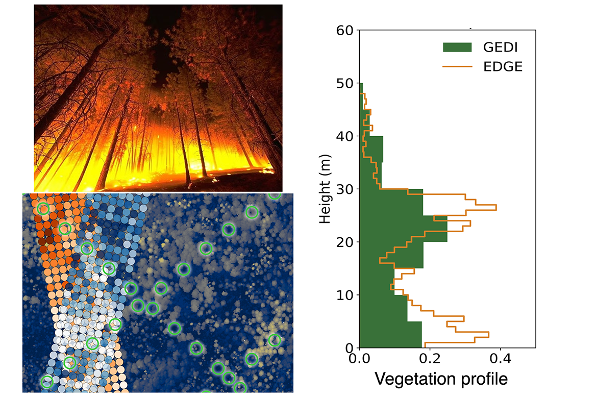
"EDGE uses laser, or lidar, technology — like that used by Waymo cars to construct a 3D picture of their environment — to measure forests and ice sheets from space at a never-before-seen frequency and resolution," Hakkenberg said. "Our goal is to provide gold-standard data, so scientists, managers and policy-makers around the world have the data to support their on-the-ground work and decisions."
The EDGE satellite's five laser beams reflect off surfaces to provide a 3D image of ground elevation, forest vegetation and even buildings, using a technology known as laser altimetry. Measuring how long it takes the laser to bounce back to the satellite reveals not only the top of a tree canopy, but also "sees" through the canopy to provide information about the lower branches and terrain, Hakkenberg said. This data will tell scientists the volume and density of plants in one-meter vertical increments, showing the structure of undergrowth, shrubs and trees. For mapping biodiversity, the variety of shapes and structures helps indicate the number of tree species in an area and can assist scientists in identifying habitats for endangered animals. The forest structure profiles can also map "ladder fuels" that Hakkenberg's research shows can serve to spread wildfires from the ground to the tree crowns.
"By mapping the full distribution of flammable materials, from ground fuels up through the canopy heights, with every satellite pass we can update fire risk maps across large areas," Hakkenberg said. "We are working with national agencies to create next-generation fuel-structure maps so wildfire managers will know where to most effectively do pre-fire treatments, where to station firefighting assets, and which wildland-adjacent neighborhoods are at higher risk."
Existing satellites provide much lower-resolution data of tree canopy structure. The current state of the art for roughly one-meter 3D structure mapping is airborne lidar, which usually requires expensive, one-off plane flights over small areas, with findings that can't be precisely replicated year to year, Hakkenberg said. NASA's Global Ecosystem Dynamics Investigation (GEDI) is the current state of the art in spaceborne lidar, but it does not provide continuous data like EDGE, nor does it offer its 1m vertical precision or near-global coverage. With EDGE, there will be near-continuous global vegetation data to update maps, potentially multiple times annually. When paired with airborne lidar in a statistical model, EDGE's data create a voxel map — the 3D version of a pixel map that looks something like a Minecraft game — that will simultaneously show 3D animal habitats and wildfire fuels, and how they are changing over time.
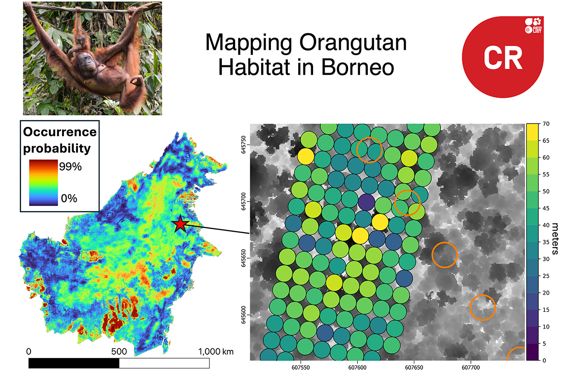
As biodiversity co-lead, Hakkenberg and partners will produce global maps of "vegetation structural diversity" that governments, universities and conservation groups can use to identify habitats most likely to support endangered animals. In a recent paper, they applied this approach to map threatened mammal habitats in Borneo for species including orangutans, clouded leopards, Asian elephants, tigers, pangolins and sun bears.
The work "will help NASA better understand Earth and improve capabilities to foresee environmental events and mitigate disasters," according to the NASA announcement. As part of the broader Earth Systems Explorers Program, EDGE will help promote "understanding Earth's surface topography, ecosystems and atmosphere, while also enabling longer range weather forecasting."
"NASA uses the unique vantage point of space to study our home planet to deliver life-saving data into the hands of disaster response and decision-makers every day for the benefit of all, while also informing future exploration across our solar system," said Nicky Fox, associate administrator, Science Mission Directorate, NASA Headquarters in Washington.


