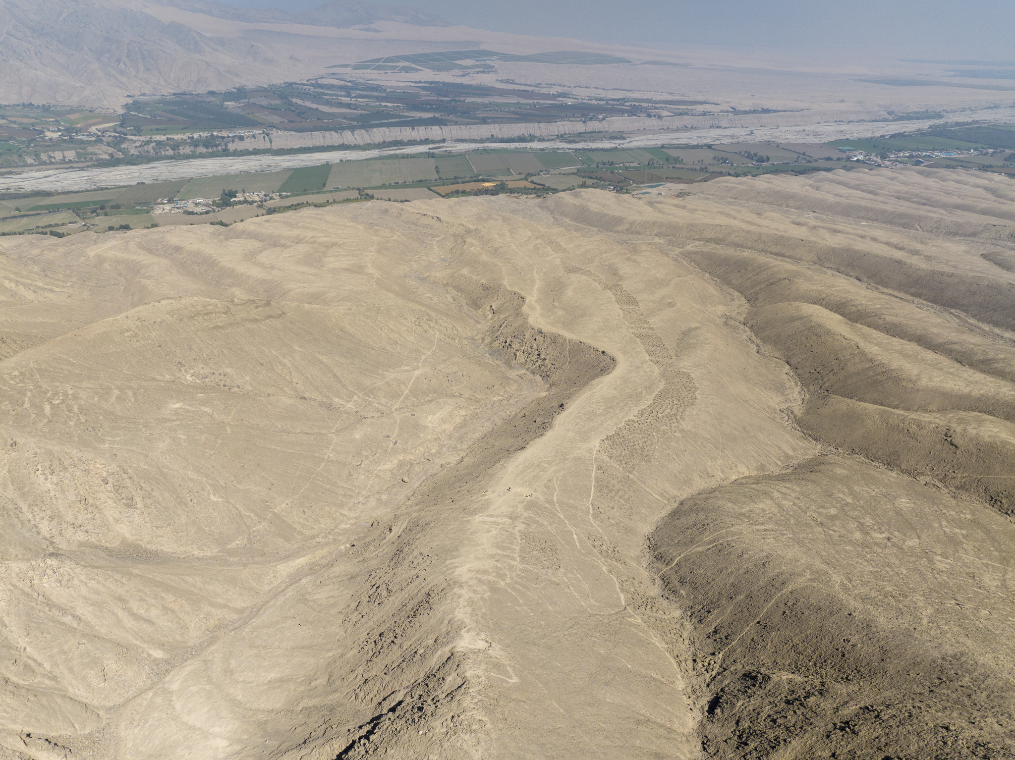
New research from the University of Sydney has uncovered compelling evidence that brings us closer to solving the mystery behind one of the most unique archaeological sites in the Andes. Monte Sierpe (translated as 'serpent mountain' and known colloquially as the 'Band of Holes') is located in the Pisco Valley of southern Peru and consists of over 5000 precisely aligned holes.
This striking, yet puzzling, site has baffled researchers and public audiences for decades.
"Why would ancient peoples make over 5000 holes in the foothills of southern Peru? Were they gardens? Did they capture water? Did they have an agricultural function? We don't know why they are here, but we have produced some promising new data that yield important clues and support novel theories about the site's use," said Dr Jacob Bongers, lead author and digital archaeologist at the University of Sydney, and a Visiting Research Fellow at the Australian Museum Research Institute.
Using drone technology, the research team mapped the site and found numerical patterns in the layout that hint at an underlying intention in the site's organisation. To their surprise, the team also discovered that the arrangement of Monte Sierpe is similar to the structure of at least one Inca khipu (an ancient knotted-string accounting device) that was recovered from the same valley.
"This is an extraordinary discovery that expands understandings about the origins and diversity of Indigenous accounting practices within and beyond the Andes," Dr Bongers said.
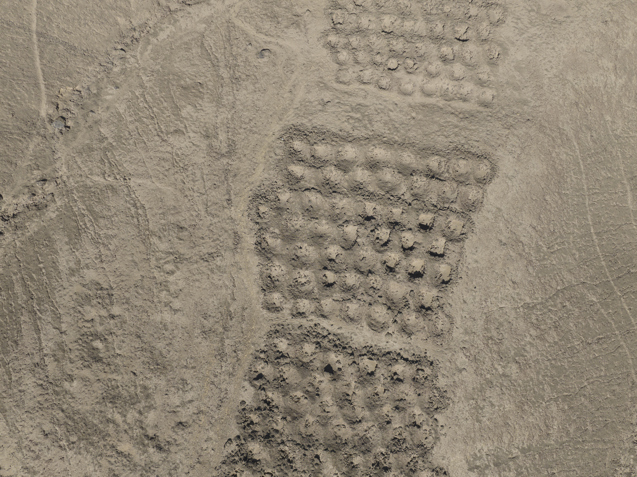

Monte Sierpe: a-c) aerial photographs of the Band of Holes and its surrounding environment; d) ground-level photograph of the holes. Photo: J.L. Bongers/C. Stanish

Analyses of soil from the holes found ancient pollens of maize (corn), one of the most important staple crops in the Andes, and reeds that have traditionally been used over millennia for making baskets. These unexpected findings importantly indicate that people deposited plants in the holes, using woven baskets and/or bundles for transport.
"This is very intriguing," Dr Bongers said. "Perhaps this was a pre-Inca marketplace, like a flea market. We know the pre-Hispanic population here was around 100,000 people. Perhaps mobile traders (seafaring merchants and llama caravans), specialists (farmers and fisherfolk), and others were coming together at the site to exchange local goods such as corn and cotton. Fundamentally, I view these holes as a type of social technology that brought people together, and later became a large-scale accounting system under the Inca Empire.
"There are still many more questions - why is this monument only seen here and not all over the Andes? Was Monte Sierpe a sort of 'landscape khipu'? - but we are getting closer to understanding this mysterious site. It is very exciting."
The results are published today in the journal Antiquity .
What is Monte Sierpe (Band of Holes)?
Stretching 1.5km across the Pisco Valley of the southern Peruvian Andes, Monte Sierpe is a large row of approximately 5200 precisely aligned holes (1-2m wide and 0.5-1m deep), organised into sections or blocks.
It first gained modern attention in 1933, when aerial photographs of the holes were published in National Geographic, but the monument's purpose is still uncertain.
"Hypotheses regarding Monte Sierpe's purpose range from defence, storage, and accounting to water collection, fog capture and gardening, yet the true function of the site remains unclear," said Dr Bongers.

An aerial photograph of Monte Sierpe taken by Robert Shippee and published by the National Geographic Society in 1933 (photo reproduced courtesy of the American Natural History Museum; AMNH Library negative no. 334709).
Drone mapping, soil analysis and a pre-Inca marketplace
To shed new light on this ambiguous feature of Peru's ancient landscape, an international research team led by Dr Bongers combined microbotanical analysis of sediment samples from the holes with high-resolution aerial imagery, presenting new insights into Monte Sierpe's organisation and use at both micro and macro scales.
Sediment analysis and drone photography of Monte Sierpe supports a new interpretation of this mysterious landscape feature as an Indigenous barter marketplace and accounting system.
Importantly, Monte Sierpe is strategically located between two Inca administrative sites and near the intersection of a network of pre-Hispanic roads. It is positioned in a transitional ecological zone (chaupiyunga) between the highlands and the lower coastal plain, a space where groups from both regions would have met and exchanged goods.
Combined with the microbotanical and aerial findings, this suggests that Monte Sierpe was initially constructed and used by the pre-Inca Chincha Kingdom for regulated barter and exchange, later developing into an accounting place under Inca rule.
"This research contributes an important Andean case study on how past communities modified landscapes to bring people together and promote interaction," Dr Bongers said.
Archaeology collaboration

Dr Jacob Bongers landing the drone in Peru. Photo: J. Rodríguez
Dr Jacob Bongers is a digital archaeologist specialised in drone mapping at the University of Sydney. He is the Tom Austen Brown Postdoctoral Research Associate in Archaeology in the School of Humanities and a valued core member of the Vere Gordon Childe Centre (VGCC), a Faculty of Arts and Social Sciences flagship centre devoted to bringing experts from diverse disciplines together to research humanity through time. He is also currently a Visiting Research Fellow at the Australian Museum Research Institute. Dr Bongers previously served as the Andean Archaeology expert for the Australian Museum's Machu Picchu exhibition.
Professor Kirsten McKenzie, Director of the VGCC, said Dr Bongers' work exemplifies the Centre's mission in both its multidisciplinary foundations and its exemplary engagement with community.
"We are all hugely proud of his achievement," she said. "Monte Sierpe is a high-profile site that attracts a lot of popular commentary online, including misinformation that threatens to overshadow Indigenous knowledge bases and community ownership over history and heritage.
"Dr Bongers' team brought to light an incredible example of Indigenous accounting and exchange through interdisciplinary research and diverse expertise, highlighting how cutting-edge technologies and analyses lead to a completely novel understanding of Andean communities in the past."
DECLARATION
This research was funded by a Franklin Research Grant, the University of South Florida office of the Dean and the Cotsen Institute of Archaeology at the University of California, Los Angeles. The authors thank the Peruvian Ministry of Culture for granting us a permit (000318-2024-DCIA-DGPA-VMPCIC/MC) that allowed us to carry out this study. Open access funding provided by the University of Sydney
Hero: Aerial photo of Monte Sierpe, facing northeast. Photo: Jacob Bongers

Dr Jacob Bongers holding a drone. Photo: Stefanie Zingsheim/University of Sydney


