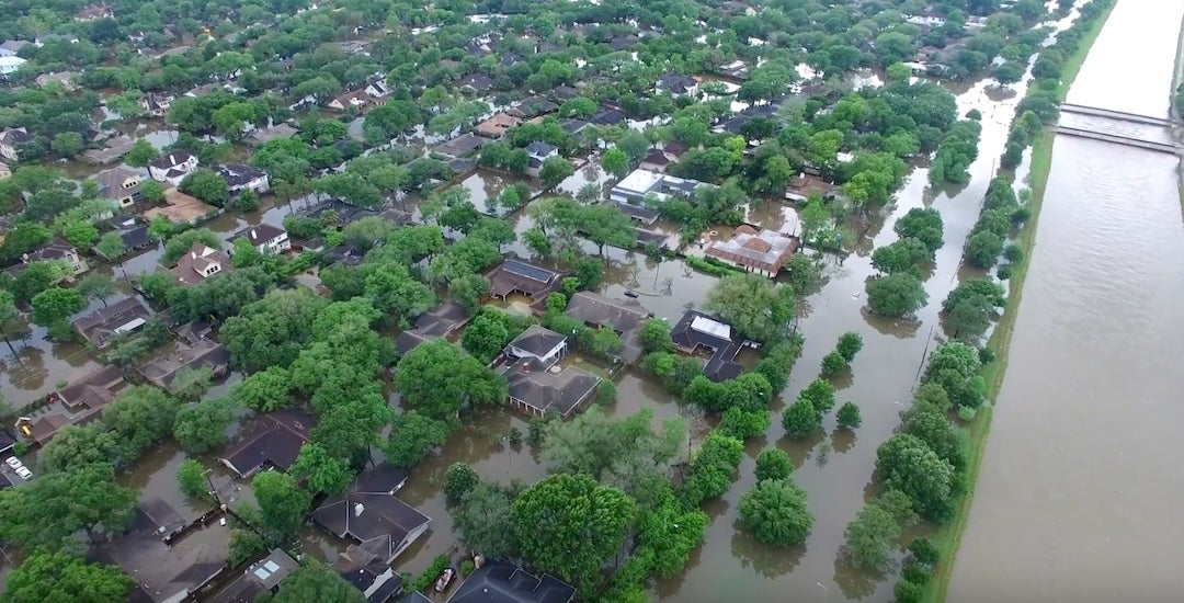
Ten years after the 2016 Tax Day flood inundated parts of the Houston region with nearly two feet of rain in a matter of hours, new research from Rice University suggests a similar storm today could have far greater consequences, especially for residents who believe they are out of harm's way.
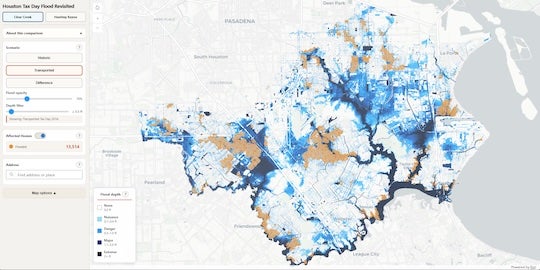
Researchers at Rice's Center for Coastal Futures and Adaptive Resilience (CFAR) used advanced hydrological modeling to simulate what would happen if a Tax Day-level storm struck more densely populated areas of the city. Their findings point to a broader and less visible flood risk that extends well beyond federally designated flood zones. The team also developed an interactive map that allows users to visualize how flooding could unfold across specific Houston-area watersheds in real time, offering a clearer picture of how quickly water could reach neighborhoods.
"The most striking takeaway wasn't just the depth of the water but how quickly it overwhelmed areas we've traditionally labeled as 'safe,'" said Dominic Boyer, professor of anthropology and co-director of CFAR. "The water didn't just rise. It rapidly flooded neighborhoods with little warning, leaving little time for traditional emergency response."
That speed is part of what makes storms like the Tax Day flood particularly dangerous. Unlike Hurricane Harvey, which brought days of advance notice, the Tax Day storm developed quickly and struck overnight.
"Harvey was a marathon of misery. The Tax Day storm was a sprint," Boyer said. "These shorter but incredibly intense deluges are in some ways harder to prepare for because they don't give the city days to mobilize."
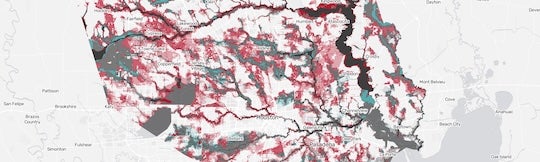
The research challenges a common assumption about flood risk in Houston. Maps produced by the Federal Emergency Management Agency guide how risk is communicated and how insurance requirements are set, but they do not fully capture how flooding behaves in a rapidly changing urban environment.
"In Houston, 'not in a flood zone' is a dangerous misnomer," said Yilei Yu, senior researcher at CFAR and postdoctoral fellow. "The lines on a FEMA map are often actuarial, not physical. Even if you technically live outside the 100-year flood zone, you are still at risk."
In one simulation of a suburban watershed near Clear Creek, more than 13,000 homes would have flooded, many outside official floodplain boundaries, and the vast majority would likely not have flood insurance. In more densely developed areas, the impacts were even more severe.
The findings reflect a broader shift in how flood risk is evolving in Houston as intense rainfall becomes more common and development continues to reshape the landscape.
"It reveals that our flood maps are still looking in the rearview mirror," said Jim Elliott, the David W. Leebron Professor of Sociology and co-director of CFAR. "We are essentially using 20th-century statistics to prepare for 21st-century deluges."
For residents, the implications are immediate. Flood risk is no longer limited to homes near bayous or the coast. It can extend across neighborhoods that have not historically been considered vulnerable.
Researchers say preparing for that reality requires a shift in how cities and residents think about flooding. Instead of focusing only on where water is expected to go, planning must also consider what happens when systems are overwhelmed.
"We need to stop asking how we can stop the water and start asking where the water is going to go when the next extreme event happens," Elliott said.
At the household level, the guidance is straightforward.
"Regardless of what the latest FEMA maps say, get flood insurance," Yu said. "The map isn't a wall."
As Houston approaches the 10-year anniversary of the Tax Day flood April 17, researchers say the event should serve as more than a historical marker. It is a reminder that storms once considered rare are becoming part of a new normal.
"We often talk about floods as 'acts of God' or 'freaks of nature,'" Boyer said. "But the increasing intensity and suddenness of extreme rainfall in our region is part of our new normal. The question is whether we are willing to plan for it before it happens again."


