A new three-dimensional model of the fault beneath the Marmara Sea in Türkiye reveals where a future major earthquake could take place, as reported by researchers from Science Tokyo. Using electromagnetic measurements, the team mapped hidden structures that help explain how earthquakes initiate and where ruptures could occur in this region. The findings help improve earthquake forecasts and could guide disaster prevention strategies for millions living in Istanbul and nearby, where seismic risk is high.
Analyzing the Structure of a Large Fault in Türkiye to Predict Future Earthquakes
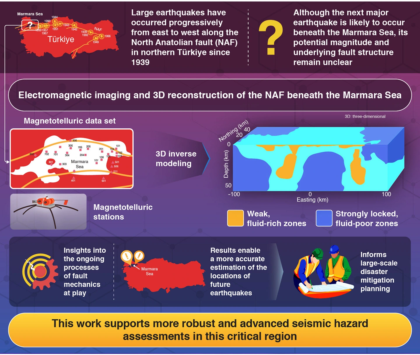
The Republic of Türkiye sits in one of the most seismically active regions of the Earth, featuring interactions between the Eurasian, African, Arabian, and Anatolian plates. Because of this, Türkiye is particularly prone to earthquakes, and many catastrophic ones have been documented since the republic was established. Since the 1939 Erzincan earthquake, which claimed the lives of over 30,000 people, scientists have noticed a peculiar pattern: destructive earthquakes follow a markedly westward migration along what is known as the North Anatolian fault (NAF).
Today, earth scientists theorize that the area beneath the Marmara Sea, which has been seismically silent for over 250 years, is the most probable location of the next large-scale earthquake. However, despite extensive research efforts in the area, the fault structure below the Marmara Sea remains poorly understood, making it hard to pinpoint future earthquake locations and implement optimal disaster mitigation strategies.
Against this background, a research team led by Dr. Yasuo Ogawa, Professor Emeritus and Research Fellow at the Multidisciplinary Resilience Research Center, Institute of Integrated Research, Institute of Science Tokyo (Science Tokyo), Japan (also Visiting Researcher at Tohoku University, Japan), along with Dr. Tülay Kaya-Eken, Assistant Professor at Boğaziçi University, Türkiye, has conducted a study that greatly deepens our knowledge of the properties beneath the NAF in the Marmara Sea. Their work, published online in the journal Geology on December 8, 2025, presents the first three-dimensional (3D) model of this critical subsurface region, providing foundational insights into the underlying processes governing earthquake generation.
To create this model, the researchers employed a large dataset of magnetotelluric measurements taken by more than 20 previously deployed stations. Simply put, magnetotelluric stations can record subtle changes in Earth's electric and magnetic fields caused by structures deep underground. This information enabled the team to reconstruct, via a process known as 3D inversion, a 3D representation of the electrical resistivity of the region down to depths of tens of kilometers beneath the seafloor.
By analyzing the final model, the team identified many distinct high-resistivity and low-resistivity zones. Since resistivity is inversely related to the presence of water, low-resistivity zones are mechanically weaker, whereas high-resistivity ones are stronger and locked in place. "We believe the resistive anomalies observed signify regions of stress accumulation, shedding light on the ongoing processes of fault mechanics at play in this critical region," Ogawa highlights. The researchers conclude that future catastrophic ruptures in this region could nucleate at the boundaries between weaker and stronger parts of the crust or at the edges of resistive zones.
Overall, this work will help earth scientists move closer to answering a pressing question for people in Türkiye, as Ogawa remarks: "Our results can be used to estimate the location and potential magnitude of future megathrust earthquakes, with significant implications for disaster prevention and mitigation." Further research efforts will hopefully contribute to saving lives and minimizing the potential damage caused by the next large earthquake at the NAF.
Reference
- Authors:
- Tülay Kaya-Eken1,2,3*, Yasuo Ogawa2,4*, Yoshiya Usui5, Takafumi Kasaya6, M. Kemal Tunçer7, Yoshimori Honkura1,2, Naoto Oshiman8, Masaki Matsushima9, and Weerachai Siripunvaraporn10
*Corresponding authors
- Title:
- 3-D electromagnetic imaging of highly deformed fluid-rich weak zones and locked section of the North Anatolian fault beneath the Marmara Sea
- Journal:
- Geology
- DOI:
- 10.1130/G52995.1
- Affiliations:
- 1Department of Earth and Planetary Sciences, Institute of Science Tokyo, Japan
2Multidisciplinary Resilience Research Center, Institute of Integrated Research, Institute of Science Tokyo, Japan
3Department of Geodesy, Boğaziçi University, Türkiye
4Research Center for Prediction of Earthquakes and Volcanic Eruptions, Graduate School of Science, Tohoku University, Japan
5Earthquake Research Institute, The University of Tokyo, Japan
6IFREE, Japan Agency for Marine-Earth Science and Technology, Japan
7Department of Geophysical Engineering, İstanbul University-Cerrahpaşa, Türkiye
8Disaster Prevention Research Institute, Kyoto University, Japan
9Department of Earth and Planetary Sciences, Institute of Science Tokyo, Japan
10Department of Physics, Faculty of Science, Mahidol University, Thailand