African scientists use satellite data and AI to produce rapid, reliable forecasts for the next few hours in
"A storm is approaching."
In many parts of the world, these words are backed by sophisticated radar scans, predictive models, and immediate action. But in much of the Global South, such as West Africa, the message either comes too late or not at all. The speed of today's weather hazards - fast-evolving thunderstorms, flash floods and intense lightning - demands forecasting that looks just hours ahead, known as nowcasting, with accuracy and relevance. But many of the regions most affected by climate extremes also have the least access to the high-resolution data and systems needed for such short-term prediction. The ANDeL (Advancing Nowcasting with Deep Learning Techniques) project is on a mission to progressively change this narrative.
Developed with the needs of resource-limited forecasting agencies and vulnerable communities in mind, ANDeL harnesses satellite data and artificial intelligence (AI) to produce rapid, reliable forecasts for the next few hours. Most importantly, the ANDeL research project aims to bridge the gap between cutting-edge science and the communities that need it most. Significantly, its developers are African scientists who understand firsthand the urgency and value of having such tools tailored to the realities of the region.
WMO World Weather Research Programme (WWRP) endorsed projects, like ANDeL, represent a crucial shift in how weather science is delivered, one that is inclusive, adaptable and designed for action in line with the goals of Early Warnings for All initiative.
The warnings gap: A global challenge
Despite impressive strides in weather and climate forecasting over the past decades, billions of people still lack access to timely, accurate warnings for imminent hazards. Short-term, high-impact weather events such as localized rainstorms or severe lightning often develop too quickly for traditional forecasting models to capture. In many developing countries, where radar coverage is limited or non-existent, this challenge is even more pronounced.
These data and infrastructure gaps translate into vulnerability. Urban floods destroy markets and homes. Without notice, storms strike farmers and schoolchildren. Energy grids and health services are disrupted with no time to prepare. It is not just a technical issue, it is a matter of equity. Communities that contribute the least to climate change are often those that suffer most from its immediate impacts, and who lack the tools to respond. This is the context in which the ANDeL project was born.
From traditional models to intelligent forecasting
For years, weather forecasting in countries like Ghana has relied on physical models. The Weather Research and Forecasting (WRF) model and Wave Watch III remain essential tools used by the Ghana Meteorological Agency (GMet)1, but the speed and complexity of climate-driven weather extremes demand more responsive, adaptive forecasting systems that are faster, locally trained and better suited for real-time applications. This is where deep learning enters the scene.
Unlike traditional models that rely heavily on physics and boundary conditions, deep learning algorithms can process massive volumes of data to uncover subtle, nonlinear patterns in the atmosphere. They operate quickly and improve continuously with more data, making them ideal for nowcasting.
Building the ANDeL Model that understands West Africa

Under the ANDeL project, a team of African scientists are working to design a deep learning model specifically trained for short-term precipitation forecasting in West Africa. The model uses the Integrated Multi-satellitE Retrievals for GPM (IMERG) dataset as a core input, drawing on both historical and real-time rainfall patterns.
At the heart of ANDeL's model architecture is a Convolutional Long Short-Term Memory (ConvLSTM) architecture2 integrated with a 3D convolutional layer3. The ConvLSTM captures how weather systems evolve over time, while the 3D convolutional layer extracts spatial features that help the model "see" how storm cells form, move and intensify. Together, they form a system that is attuned to the region's complex rainfall dynamics, capable of producing rapid forecasts that are useful at both city and district levels.
Measuring what matters: Forecast accuracy and utility
To test for model performance, ANDeL was evaluated using both deterministic and probabilistic metrics. These include point-by-point comparisons of predicted versus actual rainfall as well as estimates of the likelihood of rainfall above key thresholds (e.g. moderate or heavy downpours).
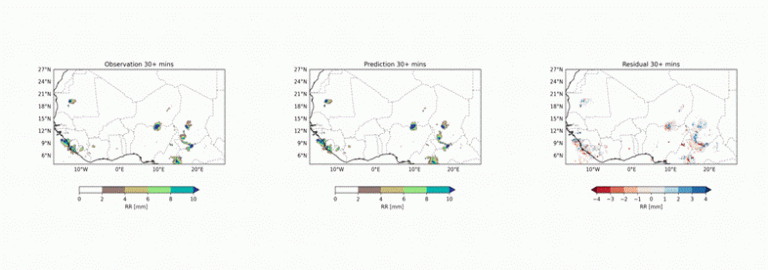
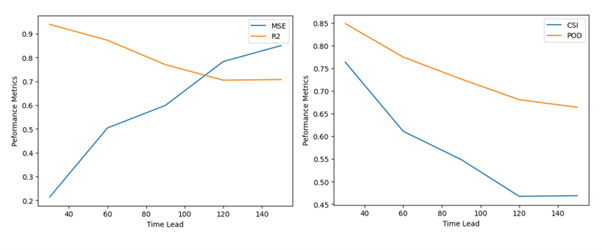
The model is able to reproduce the key spatial features of rainfall events (Figure 1), including location, intensity and movement, across diverse ecological zones in West Africa. While there are occasional distortions in localized cells, the overall precipitation fields match observed patterns well. Performance metrics, such as the probability of detection (POD) and critical success index (CSI) generally decline over successive lead time up to 150 minutes (Figure 2). Similarly, the coefficient of determination (R2) shows dwindling characteristics, coupled with increasing mean squared error (MSE).
With greater confidence in where and when intense rainfall may strike, city planners can prepare flood-prone areas, emergency responders can pre-position relief resources and schools can make informed closure decisions. In short, people can act.
Building talent, building resilience
Equally important to ANDeL's mission is capacity building. Through hands-on training workshops, mentorship and research support, the project has created opportunities for African graduate students and early-career scientists to learn cutting-edge skills in AI and climate informatics. Several graduate students are already contributing to the ANDeL model development and analysis, and a growing community of locally trained experts is progressively being equipped to contribute to Africa's climate resilience agenda. The project's emphasis on local ownership and sustainability ensures that the expertise stays where it is needed most.
Towards Early Warnings for All
For ANDeL, the value of a forecast is in its accuracy and its usefulness. That is why, from the onset, ANDeL has been focused on the operationalization of the project. The project anticipates that the rapid growth of smartphone ownership and Internet connectivity in Africa would put ANDeL nowcasts in the hands of most the continents population in the short to medium term. This accessibility means that real-time weather maps and predictive analytics can be delivered directly to users, supporting timely decision-making. Thus, ANDeL offers a preview of the African future where AI-powered weather tools are made to serve real needs in real time.
The ambition behind ANDeL aligns directly with the United Nation's global initiative for Early Warnings for All, a call to ensure every person on Earth is protected by timely and accurate warnings by 2027. Meeting that target requires more than upgrading infrastructure. It means reimagining forecasting systems to be faster, fairer and closer to the people they serve.
ANDeL shows how this can be done. By embracing open data and open science, integrating AI to overcome traditional limitations and centering communities in every step of the design process. The future of forecasting is global and is being built on global innovation grounded in local realities.
Looking ahead
Over the next year, the ANDeL project aims to expand across West Africa, incorporating more localized data, enhancing its probabilistic capabilities and linking its outputs with decision-support tools used in socioeconomic management. There are plans to make the system open-source, encouraging adaptation by other regions vulnerable to rapid-onset hazards.
The project is also exploring how to bring citizen science and community observations into the loop, allowing communities not only to receive early warnings but to participate in generating them.
References
1. Ghana Meteorological Agency, "Numerical Weather Prediction." Accessed Sep. 2, 2025. [Online]. Available: https://www.meteo.gov.gh/ Services/numerical-weather-prediction/
2. X. Shi, Z. Chen, H. Wang, D.-Y. Yeung, W.-K. Wong, and W. Woo, "Convolutional LSTM network: A machine learning approach for precipitation nowcasting," in Advances in Neural Information Processing Systems 28 (NeurIPS 2015), Montreal, QC, Canada, 2015. [Online]. Available: https://proceedings. neurips.cc/paper/2015/hash/07563a3fe3bbe7e3 ba84431ad9d055af-Abstract.html
3. Ji, S., Xu, W., Yang, M., & Yu, K. (2013). 3D Convolutional Neural Networks for Human Action Recognition. IEEE Transactions on Pattern Analysis and Machine Intelligence, 35(1), 221-231. https://doi.org/10.1109/ TPAMI.2012.59


