
Purdue University engineer Carolin Frueh studies how parts of satellites, such as the shimmering multilayer insulation materials in this photo, tend to come off over time and become space debris. (Purdue University image/John Underwood)
Purdue engineer aims to protect upcoming lunar missions from space debris
WEST LAFAYETTE, Ind. – With dozens of missions headed to the space between Earth and the moon over the next 10 years, there's bound to be traffic.
To prevent those spacecraft from running into each other, Purdue University engineer Carolin Frueh is investigating how to observe and keep track of all human-made objects and predict the impact of their potential damage in this Earth-moon neighborhood, called the cislunar region.
According to Frueh, a Purdue associate professor of aeronautics and astronautics, the reality is that solutions for space traffic in the cislunar region will be moving targets. The methods she is developing are intended to adapt to this region as traffic changes.
"There will never actually be a final answer to a space traffic management problem because as the commercial sector grows and the capabilities and types of vehicles that you have change, the problem will evolve, too," she said. "So when we think about the techniques that we want to use, we also have to be sure that what we have in mind can evolve over time."
The economic potential of cislunar space is estimated to be more than $30 billion over a 20-year period, taking into account government investment, demand for space telecommunications services and other factors.
At 238,900 miles, the distance between the Earth and the moon is 18 times longer than the Great Wall of China. That might seem like enough room for spacecraft to move around without hitting each other, but the cislunar region is far less understood than near-Earth orbits, which extend 24,000 miles beyond Earth's surface up to a "sweet spot" called the geosynchronous region that enables satellites to keep pace with Earth's rotation. Near-Earth orbits are home to most satellites. Famous residents of that area include the Hubble Space Telescope and International Space Station.
Even with more knowledge of near-Earth orbits, approximately 130 million pieces of space debris surround Earth. Much of this debris has broken off satellites that exploded or collided with other objects. Debris has already made it to the moon: A rogue rocket booster crashed onto the lunar surface last March.
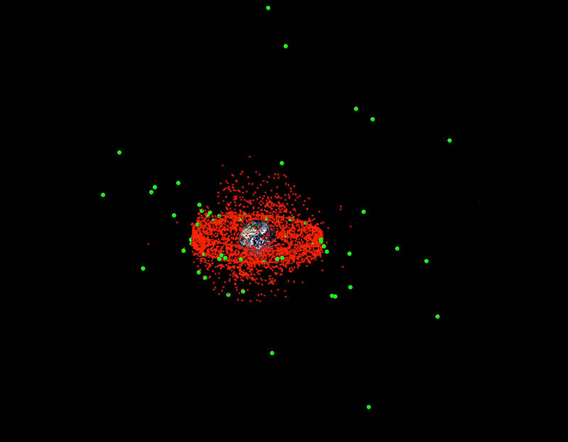 This animation shows human-made space objects cataloged by the U.S. Space Force. The red objects are in near-Earth orbits. The green objects are in the cislunar region. (Purdue University image/Carolin Frueh)
 To address forthcoming traffic in cislunar space, Frueh has been pulling from her research on how spacecraft become debris. She works with space agencies around the world to improve databases of space objects.
Doing the same for cislunar space will be difficult without being able to see as much of that larger region. For near-Earth orbits, telescopes in space and to a limited extent telescopes on Earth are among the "traffic cameras" for satellites. But there aren't any telescopes in the cislunar region because there isn't much satellite activity to observe yet. Space-based telescopes would be better at tracking cislunar satellites when more of them populate that area because ground-based telescopes can only detect a satellite of interest in cislunar space if the satellite, moon and Earth are aligned exactly right.
Together with her student, Surabhi Bhadauria, Frueh is developing a way to create "visibility maps" that would show the best regions telescopes should use to find and track human-made objects in cislunar space — including active satellites, dead satellites and fragments of satellites.
Compared to other approaches, these maps better address a big challenge with surveilling the cislunar region: space is always changing. The constantly moving positions of the Earth, moon and sun affect what a telescope observes at any given moment and which orbits it can use to see spacecraft well. Current mapping methods must re-run a model for each condition that would affect a telescope's orbit and overall viewing geometry at each instance in time, which is computationally intensive.
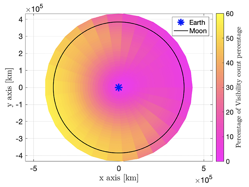 "Visibility maps" could show where to put telescopes in cislunar space to improve detection and surveillance of human-made objects, helping to prevent satellite collisions. This visibility map considers all the constraints that would affect the orbits telescopes should use to capture as much of a region as possible over a 30-day period. The map shows regions of less visibility (pink) and higher visibility (yellow) independent of the viewing direction. (Purdue University image/Surabhi Bhadauria and Carolin Frueh)
 Frueh's visibility maps run on models that more quickly and comprehensively indicate where telescopes should go to observe as much of the cislunar region as possible. The maps allow for seeing more of a region by averaging out all the orbits a telescope might use rather than integrating each orbit change over time like other mapping methods have to do. Frueh's method also doesn't require any additional computational time to show which satellites can be observed under which conditions from various locations.
"It's like planning a road trip. Right now, we have identified points of interest in the cislunar region to observe with telescopes, but we haven't found the route yet for putting the telescopes there," Frueh said.
Even when telescopes are eventually put into the cislunar region, satellites will likely just look like white dots or streaks in the images these telescopes capture. But Frueh is used to gleaning meaningful information from these shapes in telescope images of satellites in near-Earth orbits. She's working on a method that would allow researchers and mission planners to discern the orbits that a satellite is using to do its mission. The method would be designed to work under a range of scenarios – even when very little is known about the satellite.
Since it's inevitable that traffic accidents will happen in cislunar space, Frueh also is thinking ahead on how to estimate the damage an accident could cause. If a collision or explosion happens, where do all the pieces end up?
Her research indicates that pieces from a fragmented satellite can travel long distances in a relatively short amount of time. She and her student, Ariel Black, recently presented a study at the 2023 AAS/AIAA Space Flight Mechanics Meeting showing these pieces can travel effortlessly all the way back to Earth from deeper into cislunar space.
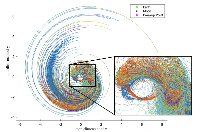 In this chart, fragments of an exploded spacecraft near the moon are predicted to disperse millions of miles away within just a month's time depending on the orbit where the explosion took place. The length of each colored line in this chart indicates how far fragments could spread in 30 days from one explosion point on an orbit of the Lyapunov orbit family around a location called the second Lagrange "L2" point. These orbits are being considered for cislunar missions. On each orbit, the explosion point is assumed to be in line with Earth and the moon. (Purdue University image/Ariel Black and Carolin Frueh)
 "We are laying the foundations that we believe will shape how space traffic management problems are addressed in the cislunar region," Frueh said.


