A series of severe convective thunderstorms across the south and eastern states recently has brought hail, lightning, strong winds and in some cases, isolated tornados to parts of South Australia, Victoria, Queensland and NSW.
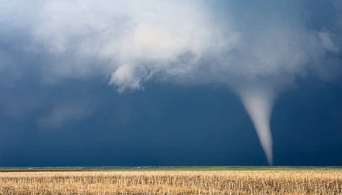
Short and sharp: Strong tornadoes can form almost anywhere in Australia and at any time of year.
Tornados are more thought of as something that might transport you from Kansas to Oz more than a typically Australian weather event, but they are more common than you may think.
Strong tornados occur within severe thunderstorms. They can form almost anywhere in Australia and at any time of the year. They require two conditions to form; one, very humid air below the cloud base and, two, strong wind shear (i.e. the twisting of winds with height) in the atmosphere above.
Since one of the prerequisites to form is humid low-level air, they most commonly occur late spring to early summer, and mostly over land (although they can also form over coastal waters, in which case they are called waterspouts).
The 1970 Bulahdelah Tornado near Newcastle is widely referred to as the most destructive tornado documented in Australia.
On average, there are around 10 to 12 sightings per year but many more probably go unreported in remote areas. The Bureau of Meteorology maintains a severe storms archive where information on reported tornados can be found.
The Bulahdelah Tornado – which occurred near the town of Bulahdelah 100 km north of Newcastle in 1970 – is widely referred to as the most destructive tornado documented in Australia.
Fortunately, there were no casualties and very little property damage, although it is estimated that over one million trees were destroyed in this event.
Cyclones far more destructive
Apart from the spinning motion, there is very little else that connects tornados with tropical cyclones. Tropical cyclones form (as the name suggests) in the tropical part of northern Australia and are much larger and longer-lived weather systems than tornados.
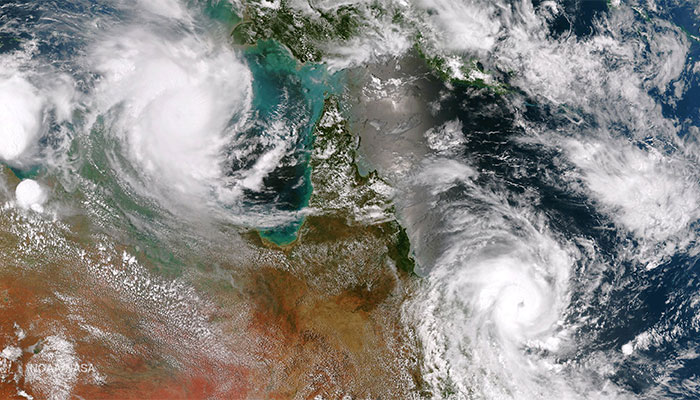
Longer lived: Two cyclones developing over northern Australia ... they require a water temperature of at least 26 degrees to form.
Because of their size and occurrence along some populated sections of the coast, tropical cyclones are far more destructive events. They bring strong winds, rain and can produce a dangerous coastal storm surge and flooding.
On average, the Australian region experiences 11 cyclones a year, although typically only four to five will make landfall. The cyclone season runs from November to April when sea surface temperatures are warm enough to trigger cyclone formation over the ocean.
Australia's deadliest recorded cyclone was Cyclone Mahina in 1899. It is estimated to have claimed more than 400 lives.
Cyclones can form outside these months; however, they require a water temperature of at least 26 degrees to form, and often dissipate quickly after they cross the coast.
Australia's deadliest recorded cyclone was Cyclone Mahina in 1899. It is estimated to have claimed more than 400 lives when it struck Princess Charlotte Bay on Cape York Peninsula in March 1899.
The impact of climate change
The effect of climate change on both tornados (or the thunderstorm systems in which they form) and tropical cyclones is difficult to predict.
In theory, warmer near-surface air temperatures may make tornados a more likely occurrence, as would warmer sea surface temperatures for tropical cyclones.
In reality, however, it is more complicated than that. Some of the best climate models we have are suggesting there will be an overall decrease in the number of tropical cyclones in the Australian region, but an increase in the intensity of the strongest cyclones. However, not all models agree.
We still know very little about how climate change will impact thunderstorm activity because these weather events are so small that they are not well captured in climate models.
The continual improvement in the resolution of climate models is helping us understand more about how climate change is impacting extreme weather events.
Dr Tom Mortlock is an Adjunct Fellow in the Department of Earth and Environmental Sciences at Macquarie University and a Senior Analyst at Aon Reinsurance.


