
Record sea surface temperatures, heat, drought, fire and floods define the state of the climate in July and early August.
Extreme heat, persistent drought and dangerous wildfires have become the hallmarks of northern hemisphere summer for many countries, whilst heavy rainfall and flooding have caused loss of life in other parts of the world.
The continuing series of high-impact weather and climate events once again underscores the need for reliable and timely forecasts and early warnings, and for monitoring and information services from the WMO community to limit the cascading impacts on society and economies.
Globally, it was the joint second warmest July on record, with an average surface air temperature 1.47°C hotter than the estimated pre-industrial baseline (1850-1900 average), according to the Copernicus Climate Change Service, implemented by the European Centre for Medium-Range Weather Forecasts (ECMWF) .
Global sea surface temperatures were the highest ever recorded for the month of July.
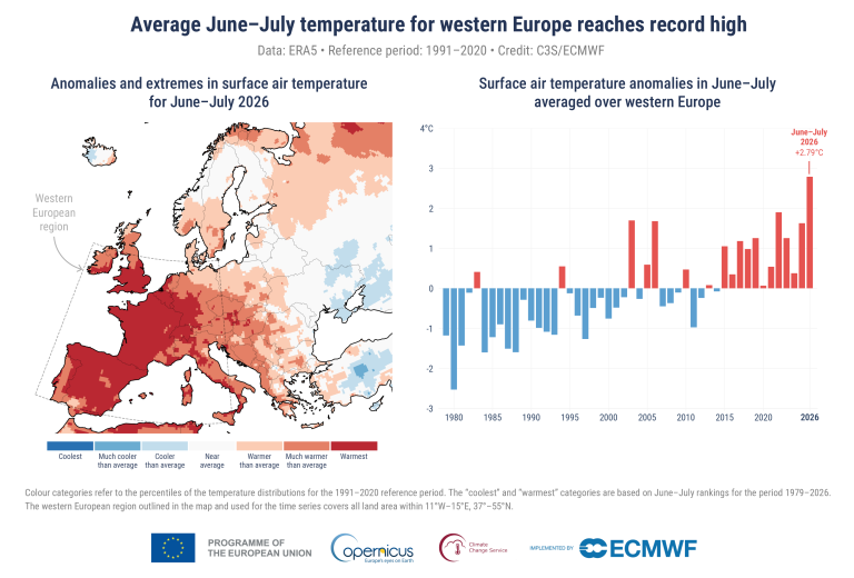
Western Europe experienced its hottest June-July period on record, and this trend continues in August, with some countries now suffering the fourth heatwave since May. The heat and exceptionally low soil moisture levels and drought are having a devastating impact on ecosystems, agriculture, river levels, transport and energy - as well as increasing the risk of fires.
According to Météo-France, nearly all the country will see extremely high temperatures - many above 35°C in the week of 10 August. MeteoSwiss has also issued a level three amber alert for temperatures of more than 35°C in the latter part of the week. The UK's Met Office says temperatures could reach 36°C in parts of southern England by 13 August.
In central Europe and the Balkans, numerous station and all-time temperature records were broken in - for example - Austria, Hungary and Slovakia in the first week of August.
Japan and the Republic of Korea both saw exceptional and record-breaking heat in the first week of August, as did other parts of Asia and the Middle East and Latin America.
Parts of West Africa are witnessing heavy monsoon rainfall and flooding, according to the WMO Coordination Mechanism, which provides information to humanitarian agencies .
In its weekly Global Hydromet Scan for humanitarian agencies on 6 August, WMO also warned of heavy to locally very heavy rainfall with the risk of flash floods and landslides this week in Northeast and west India, eastern Pakistan, Nepal, Bangladesh, Bhutan, Myanmar and some parts of South-East Asia.
Dozens of people were killed in monsoon floods in India. The India Meteorological Department advised that extremely heavy rainfall over central and northwest India, and further heavy rainfall across the Himalayan north during the week is expected. A new low-pressure area is also expected to form over the Bay of Bengal around 12 August, bringing heavy rainfall to the east coast
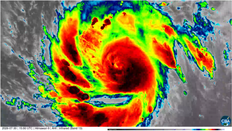
China mobilized its emergency management and response efforts, including mass evacuations, ahead of landfall of Typhoon Dolphin on 7 August, the 13th typhoon of this season and an unusually long-lasting one. The China Meteorological Administration issued many alerts and warnings in place for high winds, heavy rainfall and dangerous coastal and inland flooding .
"What we have seen over the last few months is the combined effect of long-term warming with a persistent pattern of alternating high- and low-pressure systems stretching across the northern hemisphere," explains John Kennedy, head of climate information at WMO. "The high-pressure areas are more typically associated with high temperature and dry conditions and the low-pressure areas are cooler and wetter."
"These kinds of high-pressure patterns can last days or even, as we have seen this year, for weeks. In June, these areas of high-pressure and the associated high temperatures simultaneously affected Central Asia, North America, and Western Europe. In July and at the start of August, the same approximate areas were affected as were parts of East Asia," he says.
July: a month of extremes
The monthly Copernicus Climate Change Service bulletin said that July saw the highest sea surface temperature (SST) ever recorded for July across the extra-polar oceans.
There were exceptionally high temperatures across a large portion of the tropical Pacific, an area where El Niño conditions are present and forecast to further strengthen in the coming months. Around Europe, record high SSTs along the Atlantic and western Mediterranean were associated with widespread strong or severe marine heatwaves, affecting coastal communities and ecosystems.
The exceptional spell of extreme heat continued in Western Europe. Much of the region also saw the widespread dryness observed between March and June persist and intensify, with exceptionally low rainfall and/or soil moisture reported for France, Spain, parts of Germany and the UK as well as some areas further to the East.
Across the dry regions, river flows were much lower than average or exceptionally low, with the Seine, Rhine and Danube particularly affected, impacting water supply, irrigation and energy production in several countries.
However, the average temperature over European land in July 2026 was only the eleventh-highest on record for the month, because of lower-than-average temperatures across much of eastern Europe and Scandinavia.
Outside Europe, parts of northern Canada, central USA, the Maghreb, part of the Horn of Africa, Siberia, south-central Asia, parts of inner China, parts of Argentina, Uruguay, Bolivia and Brazil were drier than average.
Parts of the eastern USA and northern Mexico, Alaska and Canada, eastern Russia, Afghanistan, parts of the Indian subcontinent, eastern China and Japan, Chile and southern Brazil were wetter than average, with flooding reported, among other regions, in the USA, Chile, Brazil, Afghanistan, India, Pakistan, Bangladesh, and China.
Wildfires
July saw exceptional wildfire activity across western Europe, in terms of the area burnt and emissions.
Fire emissions data provided by Copernicus Atmosphere Monitoring Service (CAMS) show that, for the year-to-date, 2026 emissions for France are comparable or higher than the extreme fire years of 2023 and 2022 and is on course to be one of the most extreme fire years of the past 24 years. The data for Spain also shows fire emissions to be well above average for the time of year.
Fires are currently raging in part of the western USA . In Canada there are currently 591 active fires and of these 43 are classed as being out of control, according to the Canadian Wildland Fire Information System .


