Technological development in the discipline of archaeology, which celebrates its centenary at the University of Helsinki, has been dizzying.
Observing the efforts of small student groups in the Topelia courtyard dispels the image of archaeologists in the footsteps of Indiana Jones, hands deep in the soil amidst grand adventure. They are practising documentation, measuring and the use of equipment under the guidance of University Instructor Wesa Perttola.
"Of course, we do often have our hands deep in the soil layers at digs. Physical excavation is an integral part of teaching and research in archaeology," says Doctoral Researcher Liisa Kunnas.
Kunnas is editing an anniversary publication in celebration of the discipline's centenary this year, and has familiarised herself with its development from many angles. From year to year, archaeology fascinates both the general public and new student generations. These days, the discipline can be studied in the Bachelor's Programme in Cultural Studies and in the Master's Programme in Cultural Heritage.
The greatest changes have occurred in the past decade
Technical solutions in particular have evolved from manual drawing to accurate measuring equipment.
In archaeology, survey instruments are used, for example, for general surveys, marking excavation areas in the field, measuring discoveries and structures as well as supporting other methods of documentation (e.g., georeferencing photogrammetry and laser scanning models using GPS or total station measurements).
Measurements can be linked to the national coordinate system, which means that the measured phenomena find their correct places on the map, and, for example, that the exact location of excavation sites can be shown in the field after the fact.
"In the past, everything was drawn by hand. Now, satellite positioning devices have become effective, time-saving tools," Kunnas notes. "Admittedly, I nonetheless do like drawing maps on plotting paper."
"As recently as 20 years ago, you had to rely on nothing but a levelling instrument at digs, with coordinates calculated by hand because the device only provided analogue height readings."
Photographic documentation has been part of archaeology from the beginning.
"A major transformation has taken place in the fact that 'film' and its 'development' no longer cost anything, which increases the likelihood of successful images by making it possible to take more photos and immediately see the results," Perttola says. "At the same time, the problem at the moment is how to archive digital datasets for future generations."
These days, drones are also used for photography.
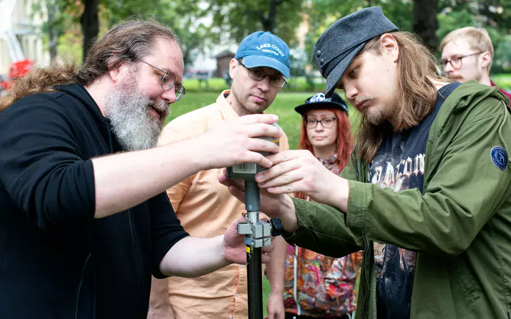
At a small-group exercise in the Archaeological Documentation course, Perttola introduces two devices known as the total station and the precision GPS. Other devices are also discussed.
Real-time kinetic positioning (RTK-GPS) is based on satellite positioning and a correction signal, which can in appropriate conditions be used to measure points directly in the national coordinate system with an accuracy of roughly 2 centimetres (compared to the ±5 m accuracy of regular hand-held GPS devices).
As for the total station, it measures horizontal and vertical angles along the line of sight, and distances with the help of a laser. On the basis of these data, the total station is able to calculate the coordinate data for measurement points, as long as it has first been provided with its own location with the help of two known points. These points can be marked in the terrain with an RTK-GPS device. The total station can be used for measurements in locations where satellite positioning does not work, such as dense forests or indoors.
"We have a robotic total station that is able to independently follow a prism at the top of a measuring rod that reflects a laser beam back down. This makes it possible to control the total station from the top of the measuring rod with the help of a field computer, with a single person carrying out the measurements," Perttola says.
Focus on the laboratory
Excavations are followed by stages of work that take place in the archaeology laboratory: finds are cleaned, processed and documented.
"Microscopes can be used to study the fine structure of fibres and, for example, to determine plant or animal species," says Laboratory Coordinator Anniina Kuha.
Kuha began working in her position in the discipline of archaeology at the University of Helsinki in late summer 2023.
Teaching in archaeology courses has also included comparative osteology, or knowledge pertaining to the bones of different species. Skeletal remains found at digs have been used to carry out skeletal analyses for species determination. Human osteology has received less attention, even though individual courses have occasionally been organised.
In laboratory facilities, further studies are carried out on materials found in excavations in terms of both objects and bones. The archaeology laboratory in Helsinki has the capacity for macrofossil analyses. Previously, phosphorus analyses have also been carried out on soil samples from archaeological sites. The equipment of the archaeology laboratory also includes XRF analysers, or X-ray fluorescence spectrometers, which can carry out elemental analyses of ceramics and other inorganic materials.
Advances in the natural sciences have added new techniques to the archaeology toolbox. Today, many research findings are uncovered in the laboratory.
In honour of the centenary of the discipline of archaeology, a seminar open to all will be held on 8 December 2023. The anniversary publication will be published at the event.


