Chinese Academy of Sciences
In 2021, global anthropogenic CO2 emissions reached a staggering 40.0±2.9 billion tons. Managing anthropogenic emissions, especially from major industries, is crucial for addressing global warming and promoting sustainable growth.
However, existing emission records lack transparency and accuracy due to limited knowledge of CO2 emissions from cities and key sectors, leading to uncertainty in the global carbon budget.
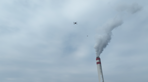
Recently, a research team led by Dr. YANG Dongxu from the Institute of Atmospheric Physics (IAP) of the Chinese Academy of Sciences has established the Low-cost UAV Coordinated Carbon Observation Network (LUCCN) equipped with medium-accurate greenhouse gas sensors for CO2 measurements. LUCCN combines ground-based and UAV-based in-situ measurement instruments, enhancing the detection and quantification capability of point source emissions in three dimensions.
The study was published in Advances in Atmospheric Sciences on Oct. 2.
"The existing and even near future satellite measurements cannot meet the frequent monitoring requirements for anthropogenic emissions due to cloud cover, aerosols, and revisit patterns," said Dr. YANG. Therefore, the development of an adaptable observation network is crucial for accurate monitoring and data collection on greenhouse gas emissions.
Using LUCCN, they conducted a campaign in Shenzhen, Guangdong Province, and Nanning, Guangxi Zhuang Autonomous Region, focusing on monitoring greenhouse gas emissions from urban and vital sectors.
Following data collection, conversion of CO2 concentration data into emission intensity is essential for validating emission inventories. In this study, the researchers utilized the UAV-measured data to calculate emission flux using a cross-sectional flux (CSF) method, resulting in a slightly overestimate than the Open-source Data Inventory for Anthropogenic CO2 (ODIAC) due to data limitations associated with UAV in-situ measurements.
ODIAC is a global high-resolution emission data product for fossil fuel CO2 emissions, originally developed under the Greenhouse gas Observing SATellite (GOSAT) project at the National Institute for Environmental Studies (NIES), Japan.
"The UAV sampling strategy and emission estimation methods require further exploration," said Dr. YANG. "We are now developing a measurement-fed-perception self-adaptation network strategy for the LUCCN system to improve monitoring efficiency, and atmospheric inversion will be applied to enhance emission estimates."
/Public Release. This material from the originating organization/author(s) might be of the point-in-time nature, and edited for clarity, style and length. Mirage.News does not take institutional positions or sides, and all views, positions, and conclusions expressed herein are solely those of the author(s).View in full here.


