
On Feb. 17, 2025, after a weekend of heavy rainfall, a hillside in Fleming-Neon, Kentucky, suddenly gave way. A wall of earth and debris tore downhill, straight toward a cluster of houses. Those houses were occupied, families inside. Tons of material thundered down - and thankfully stopped before completely burying the homes.

This was not an isolated incident. Landslides cause an estimated $10 million to $20 million in damage across the Commonwealth annually, impacting everything from private residences to critical infrastructure and roads. That problem is particularly concentrated in Eastern Kentucky, where a maze of hills, hollers, creeks and human development mean a lot of hillsides with the potential for problems.
To combat this, the Kentucky Geological Survey (KGS) is leading a landmark effort to provide communities with the data they need to stay safe. The Slope Hydrologic Monitoring Network website is a pioneering digital platform that offers real-time insights into the stability of Kentucky's hillslopes. This tool is a major milestone after years of research through the CLIMBS (Climate Resilience through Multidisciplinary Big Data Learning, Prediction and Building Response Systems) project.
The CLIMBS project is a five-year, $24 million initiative funded by the U.S. National Science Foundation's EPSCoR Program and the Kentucky Cabinet for Economic Development. It represents a collaborative statewide approach, bringing together eight institutions, including the University of Kentucky, to address critical knowledge gaps in climate understanding and disaster response.
KGS, a state-supported research center and public resource within the University of Kentucky, conducts research in the geological sciences, provides unbiased data and information to the public, and engages with stakeholders.
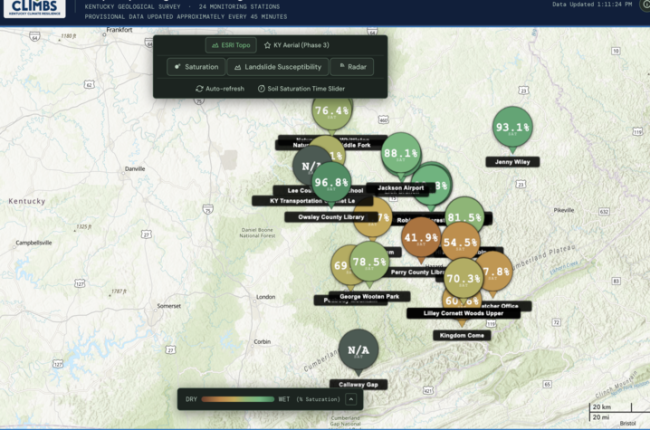
The new monitoring network consists of 24 stations strategically placed across landslide-prone terrain in Eastern Kentucky. These stations act as a first-of-its-kind, near real-time slope monitoring network in the eastern U.S., measuring vital data every 15 minutes.
"Kentucky incurs lots of damage and costs due to landslide impacts, and we want to address where, why and how these are happening," said Matt Crawford, Ph.D., adjunct professor in the Department of Earth and Environmental Sciences in the UK College of Arts and Sciences, engineering geologist with KGS and project lead.
By collecting data at this scale, CLIMBS researchers are taking a national lead in understanding hillslope response behavior relative to climate and human infrastructure - and how to forecast failure.
Putting data to use
The complexity of Kentucky's landslides can be analyzed using the "factor of safety," a numerical value used to indicate the stability of a hillslope and the likelihood of a landslide occurring under different moisture, soil and vegetation conditions. During intense rain, water seeps into the ground, increasing soil saturation and reducing the slope's ability to hold its own weight.
"Even after the rain stops, the factor of safety can continue to decrease because that rainwater doesn't just disappear. It continues to move through the soil," said Sarah Johnson, Ph.D., research assistant professor in the Department of Earth and Environmental Sciences in the UK College of Arts and Sciences and project researcher. "Landslides may occur after the rain has stopped."
By monitoring volumetric water content (how much water) and matric potential (how that water is behaving) at multiple depths, the 24 sensors allow researchers to connect landslide occurrences and other slope changes directly with soil moisture records. This data is then used to develop weather-driven landslide forecasting models. Using machine learning and physics-based methods, these models can forecast when a slope is reaching a critical threshold, potentially giving emergency managers and residents like those in Fleming-Neon hours or days of advance notice.
The new website makes this complex data accessible to the public. The core feature is interactive maps, where stations are represented by bubbles that change color based on soil saturation. Users can also overlay National Weather Service NEXRAD radar to see storms moving toward sensitive areas in real-time. A toggleable layer shows classifications of which slopes are most prone to failure based on Light Detection And Ranging data, and a14-day history allows users to track how a particular slope has responded to recent weather events.
"This is a phenomenal tool that rivals any similar network in the U.S.," said L. Sebastian Bryson, Ph.D., Hardin-Drnevich-Huang Professor of Civil Engineering, chair of the Department of Civil Engineering in the Stanley and Karen Pigman College of Engineering, and CLIMBS co-principal investigator.
The impact of CLIMBS extends beyond data points. The project relies on deep community partnerships to identify sensor locations and conduct local trainings. Researchers have collaborated with the Cowan Community Center, Hindman Settlement School, UK's Robinson Forest, Kentucky State Parks, Hazard High School, the U.S. Army Corp of Engineers, Daniel Boone National Forest, Eastern Kentucky University and county emergency managers throughout the Commonwealth.
By making this data public and leveraging local partners, Kentucky is moving toward a future where heavy rainfall no longer means disaster for those living in Appalachian Kentucky.
To view the real-time slope data, visit the Slope Hydrologic Monitoring Network website at kgs.uky.edu/slope-monitoring.
This material is based upon work supported by the U.S. National Science Foundation under Cooperative Agreement No. 2344533 and 1849213. Any opinions, findings, and conclusions or recommendations expressed in this material are those of the author(s) and do not necessarily reflect the views of the U.S. National Science Foundation.


