Key Points
- The intensely powerful and destructive Hunga blast was unlike previous events, It was a unique event in that scientists were able to capture the eruption with satellite imagery and other instruments.
- The Hunga volcano started out with a flat upper surface to a depth of 150 metres before the eruption, which ejected at least 6.5 cubic kilometres of ash and rock and left a deep caldera 250 metres below sea level.
- Electron microscopy revealed different concentrations of chemicals in the two types of magma that came together and mingled to form distinctive swirling bands in the samples. Infrared beamline analysis techniques provided crucial information about the diffusion of water in the tiny fragments.
- The chilling effect of the water as the magma fragmented, the concentration of water and the chemical composition of the particles also provided clues about the depth at which the event occurred.
When the Tongan Hunga volcano erupted in January this year, it was a huge explosion with a mass ejection that reached more than 55 kilometres into the atmosphere, causing local fatalities and evacuations. The blast created significant tsunami waves in the Pacific Basin and generated pressure waves that encircled the globe.
Although not a significant inundation, the impact of the tsunami reached Australia with waves of 82cm at the Gold Coast, 65cm at Port Kembla and 77cm at Eden's Twofold Bay in NSW.
In an effort to understand why the eruption was so explosive, internationally-recognised volcanologist Prof. Shane Cronin of the University of Auckland and associates rely on beamlines at the Australian Synchrotron to support comprehensive research on the Hunga event.
Two sets of experiments have already been carried on the Imaging and Medical beamline and the Infrared Microspectroscopy beamline, while another investigation is scheduled for the X-ray fluorescence microscopy beamline.
He hopes that microscale clues he gains from the research on Hunga could then be applied to study other situations for better monitoring of volcanoes in the Pacific and beyond.
"There was no warning of the eruption, which had devastating consequences for Tonga and many Pacific Island countries," Prof. Cronin said.
"We've never seen an eruption of this kind before, which was the most powerful in last 140 years," said Prof. Cronin.
It was also a unique event in that scientists were able to capture the eruption with satellite imagery and other instruments.
Prof. Cronin acquired very fresh samples shortly after the event, including sea floor sampling of the ocean floor undertaken by the South Korean Polar Research Institute ice breaker Araon (which happened to be in the area).
Although there are numerous underwater volcanic eruptions, the intensely powerful and destructive Hunga blast was unlike previous events.
"Even direct magma-water contact is not enough to explain what happened with Hunga," he explained.
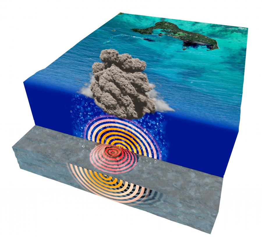
The Hunga volcano started out with a flat upper surface to a depth of 150 metres before the eruption, which ejected at least 6.5 cubic kilometres of ash and rock and left a deep caldera 250 metres below sea level.
"We think there was a magma-water interaction that was just deep enough to cause direct water magma contact in a volcano that was collapsing in on itself with lots of fractures in the sea wall, and a mixing of magma that released gas and built-up pressure."
Most of the evidence of the eruption was contained in very fine glassy particles of ash, which was previously thought to be indicative of a smaller eruption.
Electron microscopy revealed different concentrations of chemicals in the two types of magma that came together and mingled to form distinctive swirling bands in the samples.
These fragments were then analysed by Prof. Cronin's team using the Infrared beamline at the Australian Synchrotron with the assistance of beamline scientist Dr Mark Tobin and Dr Pimm Vongsvivut.
An infrared technique provided crucial information about the diffusion of water in the tiny fragments.
"The infrared beamline can be very useful in geological investigations, such as analysing volcanic ash at the micron scale, by providing maps of different elemental contributions and the compositional variations of some of the most volatile elements," said Dr Mark Tobin.
"Because water concentration in the two magmas was different, it suggested the event was very brief and could only have happened when the magma interacted with seawater and broke apart and not before," said Prof. Cronin.
The chilling effect of the water as the magma fragmented, the concentration of water and the chemical composition of the particles also provided clues about the depth at which the event occurred.
"We think it happened somewhere within the edifice of the volcano, about 400-500 metres below the sea surface and this helps us understand the forces driving the eruption."
"The magma mingling process generates a whole lot of volatile material and excess expansion that drives the eruption."
Prof. Cronin and his team used microCT on the Imaging and medical beamline at the Synchrotron to analyse the microstructure of pumice created in the explosion.
They were looking for bubbles in the texture of the porous samples, which were formed mid-eruption.
"We can see bubbles forming, coalescing and collapsing, which provides a snapshot of the state of the magma at the time it was frozen," explained Prof Cronin.
"There was a competition between the internal gas expanding and then the water from the outside chilling and breaking things down, which provided insights into the upper part of the explosion."
Another aspect of the research will focus on the deeper scale processes using X-ray fluorescence microscopy and other techniques on the samples of material from the ocean floor.
The team will be looking at the oxidation states of iron and other key elements to understand processes that are occurring at great depths and conditions which may have contributed to the remarkable event.
There are at least 10 volcanic seamounts in the wider region of the south-west Pacific that could produce something similar to the Hunga explosions on a shorter timescale."Understanding just how often they might have this kind of eruption with the perfect water dips and also with this kind of mingling of magma would be really important in informing risk assessments."


