An international study by the UAB, the Planetary Science Institute, and the NASA Ames research center has shed light on the geological history of the site where the first probe to operate successfully at Mart landed in 1976. The origin of those rocky plains was a megatsunami generated by an asteroidal collision into a shallow ocean, suggesting that the landing site would have been suitable for carrying out the life-detection experiments. The research, published in Scientific Reports, is based on identifying an oceanic crater and simulations of the wave generated by the asteroid's impact.
On 20 July 1976, the Viking 1 landing module launched by the United States made history by becoming the first spacecraft to operate successfully on the surface of the red planet. The probe landed in the lower reaches of the Maja Valles, a huge channel formed by catastrophic river floods some 3,400 million years ago, in the Chryse Planitia region. One of its main objectives was to find evidence of life in samples of the soil, so it was essential to land in a place where there was a good chance of finding it. It was thought that the ancient flood channels were outstanding candidates. However, to the surprise of NASA scientists, the probe returned images of rocky deposits with no diagnostic features of ancient floods. Some explanations were proposed, such as that the sedimentary deposits were composed of ejecta blankets caused by meteorite impacts or degraded lava flows. Still, there were no sufficient impact craters or abundant lava fragments. The origin of the landing site thus became a mystery in the history of planetary exploration.
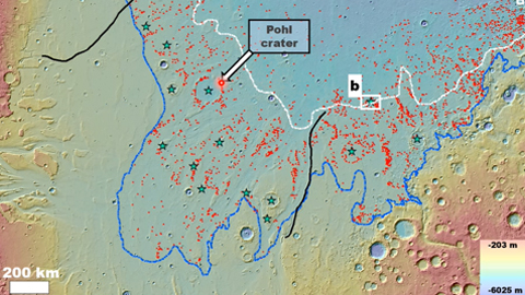
A study published in Scientific Reports has now revealed that the site where Viking 1 landed is a mega-sunami formed by a megatsunami generated by the impact of an asteroid between 3 and 9 kilometers in diameter, which collided with a shallow northern ocean. The work, which clarifies the geological history of the landing site, was led by J. Alexis P. Rodríguez, a researcher at the Planetary Science Institute (USA), and María Zambrano researcher at the Autonomous University of Barcelona (UAB), and Mario Zarroca, a researcher at the Department of Geology at the UAB.
The results of the study are based on the identification of a crater of marine origin, as well as on high-resolution numerical simulations of the wave generated by the asteroid impact showing margins that match the older of two megatsunamis that the researchers had previously mapped. The study also includes the finding, in high-resolution images, of patterns of dissection that match the numerical predictions of megatsunami flooding at and around the landing site.
"Our simulations show that the megatsunami was devastating, initially reaching an initial wave height of 250 meters and inundating coastal areas located at least 2,000 km from the impact crater. These coastal areas include a huge basin where the wave could have formed an inland sea on the planet's tropics", says Mario Zarroca.
Marine craters are essential to understanding the evolution of coastal environments
"The search for marine crustaceans is extremely difficult, but it is essential to understand the evolution of coastal environments on the red planet. The palaeoceanic basin includes many scattered craters that formed long before or after the ocean. Other studies have proposed possible marine craters. Ours is based on multiple remote sensing and computer simulation tests, which has allowed us to identify the first crater in Mart with stratigraphic, geographic, and numerical relationships indicative of an oceanic impact origin", explains Alexis Palmero Rodríguez.
The crater is above the landscapes formed by the floods generated by the ocean and covered by the deposits of the most recent megatsunami, which have already been mapped by researchers. "It is possible, therefore, that it contains a geological record detailing the evolution of the ocean from its formation to its freezing," said Rodríguez.
New geological context for the search
NASA determined that the Viking 1 experiment had not provided clear evidence that Mart harbored signs of microbiological life in the soil near the landing site. The study published today is not directly relevant to these results. Still, the researchers point out that the linking of the rocky plains to the northern ocean provides a new geological context for interpreting the experiment and invites scientific reconsideration of the astrobiological information collected in the first in situ measurements on Mars.
"The landing module detected salts on the ground. If it is proven that these salts were of marine origin, we could predict a brackish composition of seawater that would have been much more resistant to freezing than terrestrial seas. Furthermore, this type of composition exists in some lakes on Earth, containing organisms capable of living in such extreme environments. If the ocean formed a ice layer, this saline composition could have significantly lengthened its liquid state, stabilizing its habitability. Therefore, the landing site was indeed the right place to carry out the experiment", argues Mario Zarroca.
The next step for the researchers will be to characterize numerous terrains close to the identified crater as possible landing sites according to their potential for habitability and housing evidence of ancient biosignatures. "For example, we have found evidence of a prolonged glaciation around the ocean that eroded the edge of the crater and many other coastal ridges. It must have been a humid glaciation, which means that the climate continued to feel somewhat similar to Earth's, similar to the Alaskan winters. This is important because it indicates a potential for habitability. Furthermore, we have found mud volcanoes in and around the crater, which constitute sedimentary structures where, if they had existed, evidence of biological activity could have been concentrated and then exposed to the surface," says Rodríguez.
Schematic reconstruction showing the history of formation and modification in the Mart region of Chryse Planitia. (a) The crater (known as Pohl) is formed in a shallow marine environment, (b) triggering water flow fronts and rocky megatsunami deposits. (c) The wavefronts inundate the high and lowland boundary plains extensively, including a section approximately 900 km southwest of the impact site. (d) The ocean recedes to -4,100 m, accompanied by a regional dissection of the glaciers that eroded the crater's rim and other craters. (e) The most recent megatsunami overflows the crater and parts of the older megatsunami. The glaciation continues, and later mud volcanoes are formed. (f) Some 3,400 million years later, the Viking 1 landing module lands on the edge of the oldest megatsunami deposit. (Scientific Reports).
Article: Alexis P. Rodriguez, Darrel K. Robertson, Jeffrey S. Kargel, Victor R. Baker, Daniel C. Berman, Jacob Cohen, Francois Costard, Goro Komatsu, Anthony Lopez, Hideaki Miyamoto, Mario Zarroca. Evidence of an Oceanic Impact and Megatsunami Sedimentation in Chryse Planitia, Mars. Sci Rep (2022). https://www.nature.com/articles/s41598-022-18082-2


