Rapidly melting glaciers are surging water volume in at least 10% of rivers in High Mountain Asia, including large rivers like Yangtze, Amu Darya and Syr Darya, according to a comprehensive new study of the region. In parts of upstream rivers, water flow nearly doubled over the course of a decade.
Communities that depend on the rivers for power could benefit from the increase in river power, but additional sediment carried in the water may clog infrastructure. The increase is currently found specifically in upstream parts of the rivers, but downstream communities could face the same outcome as glaciers continue to melt.
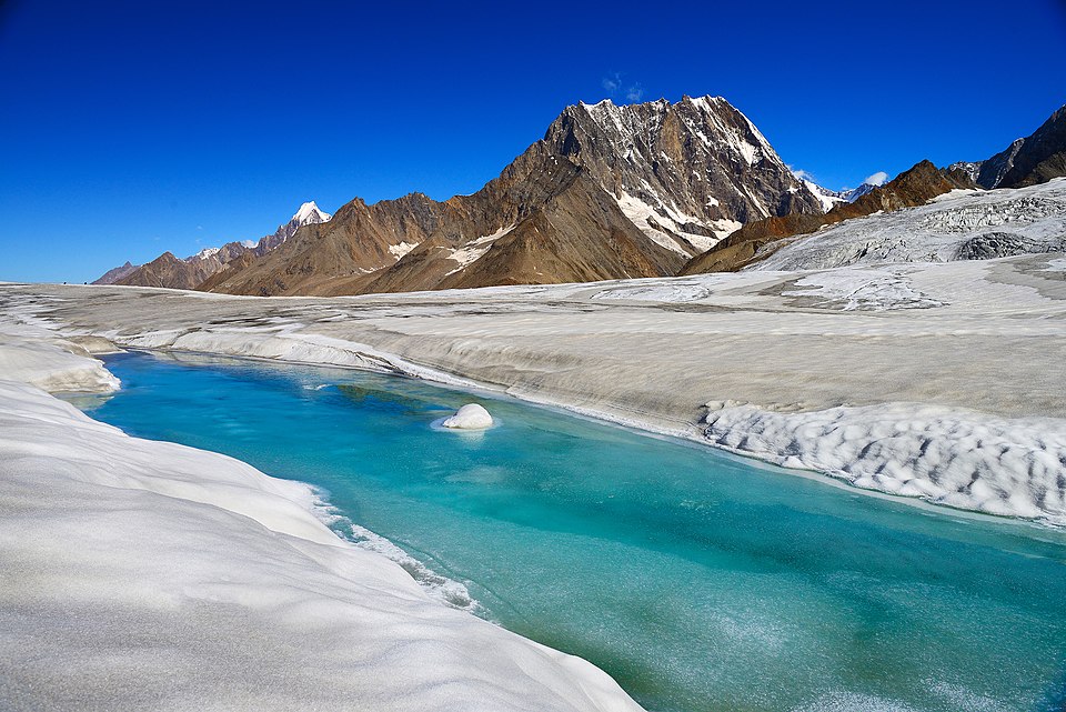
Encompassing the Himalayas and the Hindu Kush and powerful rivers like the Yangtze, Yellow and Indus, High Mountain Asia is a complex geographic region that supplies water to around two billion people. The rivers are primarily fed by glaciers, snow and rainwater, but the river systems are changing as a result of climate change impacting temperature, monsoon season and droughts. Previous research has projected the glaciers in High Mountain Asia will lose between 29% and 67% of their total mass by 2100.
The new study investigated how the amount of water flowing through the river has changed as a result of melting glaciers and snow and changes in rainfall. This is the first study to look at the entire mountain range and its river and zoomed in to examine how each individual section of these rivers was impacted.
"Increased river discharge offers short term benefits such as more water for hydropower and agriculture, but it also signals sediment increase and glacier loss," said Jonathan Flores, an engineer at the University of Massachusetts and lead author on the study. "If these glaciers continue to shrink, their meltwater contribution to river systems will decline, which will then threaten long term water availability for the downstream."
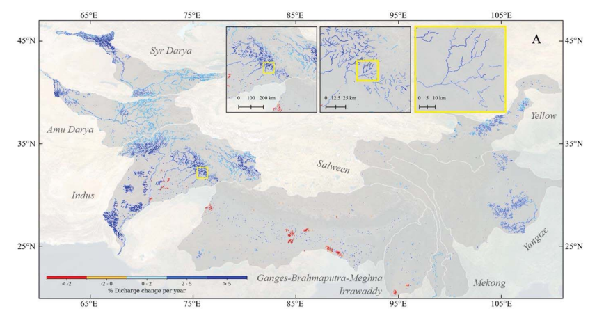
The average percentage change in river discharge, or river flow, per year, is increasing over much of High Mountain Asia. Red and orange represent decreases in river discharge and blue represents increases in this map of the Himalayas, Karakoram, Pamir and Tian Shan. The inset maps depict the detailed measurements of the new study, down to 5-mile segments. Credit: Flores et al. AGU Advances
The study was published today in AGU Advances, which publishes high-impact, open-access research and commentary across the Earth and space sciences. The research measured more rivers than previous studies and divided them into 8-kilometer (5 mile) segments, which provided more detailed and tailored results.
Researchers found that 10% of rivers had seen an increase in river discharge, or the amount of water moving through the river, during the study period from 2004 to 2019. On average, these rivers saw the discharge rate increase of 8% per year. Sections of larger rivers that have more than 1000 cubed meters (265,000 gallons) of water moving through them per second, such as the Yangtze, had an average increase of over 2% per year, or an extra 5,300 gallons per second . Increases upstream may not correlate to increasing discharge further downstream, which is the case for many of the measured rivers.
The results show a double-edged sword. An increase in water can help with agriculture, electricity and general water usage, but an increase in water discharge directly correlates to an increase in stream power, or how much sediment like sand, silt and gravel is being moved through the river.
Sediment is natural in waterways, but an increase in sediment can come with consequences. Increased sediment can slow down machinery inside hydropower machinery, accumulate inside dams meant to hold water for the dry seasons, and damage river ecosystems with sensitive wildlife.
"The natural aquatic habitat can be altered by this increasing trend and the ecosystems that were previously stable can be altered and changed," said Flores. Rivers in the western part of High Mountain Asia are fed by glaciers where rivers in the east are mostly filled through rain. As a result, it was primarily the rivers in the west that saw an increase in discharge because climate change is increasing the speed of melting glaciers.
They used over one million pictures from Landsat and PlanetScope satellites to track the changes of the rivers while confirming their estimates through water gauge measurements from various sites across the region.
The information they collected is open source for anyone to use. As plans are made for the construction of new dams or hydropower plants, this information could be used to increase how much water the plants could intake, meaning higher water storage or increased electrical capacity.
"Most of the water infrastructure like dams are designed based on historical data," said Flores. "They can see that in this study we found that there are increasing trends in the data, so that can be a factor in their decision and planning and optimizing the design."
Of the 1600 dams or planned dams measured in the study, 8% saw an increase in stream power, meaning more sediment moving through the dams. Flores said the increase in sediment could lead to higher stress being put on the machinery as it would need to move not just the water, but all the sand and dirt it begins to accumulate. Additionally, dams used to store water during the dry season could fill up with sediment and limit their capacity.
"When we tried to have a field visit in Nepal, we were able to visit these communities and hydropower plants and infrastructure, and we found that these are very important to them," Flores said. "Most of the communities are reliant on hydropower electricity in this region."
Flores said he hopes the open-source information can be used by local communities to better plan their water resource management for coming years.
Notes for journalists:
This study is published in AGU Advances, an open-access AGU journal. View and download a pdf of the study here. Neither this press release nor the study is under embargo.
Paper title:
"Accelerating river discharge in High Mountain Asia"
Authors:
- Jonathan Flores (corresponding author), Department of Civil and Environmental Engineering, University of Massachusetts, Amherst, Massachusetts, USA
- C. J. Gleason, University of Massachusetts, Amherst, Massachusetts, USA
- C. Brown, University of Massachusetts, Amherst, Massachusetts, USA
- N. Vergopolan, Rice University, Houston, Texas, USA
- M. M. Lummus, University of Pennsylvania, Philadelphia, Pennsylvania
- L. A. Stearns, University of Pennsylvania, Philadelphia, Pennsylvania
- D. Li, Peking University, Beijing, China
- L. C. Andrews, NASA Goddard Space Flight Center, Globel Modeling and Assimilation Office, Greenbelt, Maryland, USA
- D. Basnyat, Nepal Development Research Institute, Patan, Nepal
- C. B. Brinkerhoff, Yale School of the Environment, Yale Institute for Biospheric Studies, Yale University, New Haven, Connecticut, USA
- R. Ducusin, York University, Toronto, Ontario, CAN
- D. Feng, University of Cincinnati, Cincinnati, Ohio, USA
- E. Friedmann, University of Massachusetts, Amherst, Massachusetts, USA
- X. He, University of Massachusetts, Amherst, Massachusetts, USA
- M. Girotto, University of California, Berkeley, California, USA
- S. V. Kumar, NASA Goddard Space Flight Center, Globel Modeling and Assimilation Office, Greenbelt, Maryland, USA
- R. B. Lammers, University of New Hampshire, Durham, New Hampshire, USA
- G. Lamsal, Nepal Development Research Institute, Patan, Nepal
- F. Z. Maina, NASA Goddard Space Flight Center, Globel Modeling and Assimilation Office, Greenbelt, Maryland, USA
- A. A. Proussevitch, University of New Hampshire, Durham, New Hampshire, USA
- A. Richey, Washington State University, Pullman, Washington, USA
- E. Shevliakova, NOAA Geophysical Fluid Dynamics Laboratory, Princeton, New Jersey, USA
- D. Subedi, Nepal Development Research Institute, Patan, Nepal
- J. Wang, University of Illinois, Kansas State University, Champaign, Illinois, USA
#
AGU (www.agu.org) is a global community supporting more than half a million advocates and professionals in Earth and space sciences. Through broad and inclusive partnerships, AGU aims to advance discovery and solution science that accelerate knowledge and create solutions that are ethical, unbiased and respectful of communities and their values. Our programs include serving as a scholarly publisher, convening virtual and in-person events and providing career support. We live our values in everything we do, such as our net zero energy renovated building in Washington, D.C. and our Ethics and Equity Center, which fosters a diverse and inclusive geoscience community to ensure responsible conduct.
#
Contributed by Riley Thompson


