RICHLAND, Wash.-Hurricanes will become stronger and strike more often on the U.S. Gulf and lower East coasts, according to new research led by scientists at the Department of Energy's Pacific Northwest National Laboratory, who explored the influence of global warming on the damaging storms. Should current warming trends continue, they caution, landfalling hurricane frequency could rise by a third compared to current levels.
In a paper published today in the journal Science Advances, researchers describe a previously unknown mechanism that fuels escalating risk to coastal residents.
Changes in the winds of Earth's upper atmosphere-induced by a warming sea surface in the Eastern Pacific Ocean-are responsible for the projected boost in hurricane frequency in the coastal regions.
"What we found is that these wind changes have a double whammy effect," said lead author and climate scientist Karthik Balaguru. "First, they steer storms closer to the U.S. East and Gulf coasts, which brings risk to the people who live there. But these same wind changes also reduce vertical wind shear near the coast, and that will ultimately strengthen coastal storms. When these two factors work together, it exacerbates the whole problem."
Much work has been done to identify the changes that make storms more damaging in a warming world. For example, previous studies have projected that vertical wind shear-a force that typically dulls a hurricane by sapping its strength-will weaken under global warming. Weaken wind shear, said Balaguru, and you'll strengthen storms.
Other research has projected that hurricanes may move more slowly, granting the storms more time to inflict harm. But, until now, such changes have largely been attributed to the general influence of global warming, with no mechanism identified.
"Global warming can mean a lot of different things," said Balaguru. "We wanted to know exactly what, in a warmer world, is responsible for these changes. Uncovering the reason behind those changes, as we've done here, is both satisfying from a scientific standpoint, but also very important as we deepen our understanding of what influences extreme weather."
More hurricanes, more risk
To understand how risk posed by hurricanes could look in the future, Balaguru needed one thing: more storms. Only a few hurricanes make landfall in the U.S. each year-far too few for robust analyses.
Researchers typically simulate hurricanes in models that represent Earth's climate. But those simulations can quickly grow computationally expensive. The models must have sufficiently high resolution and, to generate the numbers needed to make trustworthy projections, researchers would have to perform many simulations of storms.
Balaguru and his coauthors instead developed a unique model known as RAFT. The advantage of RAFT lies in its ability to unravel the many factors that shape hurricanes, from the winds that steer storms to the warm waters from which they draw power. Meant to be combined with climate models, it can also generate many simulated storms, which makes robust statistical analyses possible.
This ability allowed Balaguru's team to examine the relative significance of each contributing factor behind the changes. The resulting study, said Balaguru, marks the first time such an analysis has been carried out.
"We saw that storm frequency near the coast was changing," said Balaguru. "But why? Is it because the storms are getting stronger? Is it because they're heading more in that direction? Our approach helped us isolate the key variables at play and determine which was most important."
RAFT generated hundreds of hurricane tracks: the paths that hurricanes take after they form over ocean waters. The results showed that, if current warming trends continue, storms would both strengthen and more frequently reach the East and Gulf coasts.
In ramping up the frequency of landfalling hurricanes, Balaguru's team found that one factor stood more dominant than all others: wind.
What's making hurricanes worse?
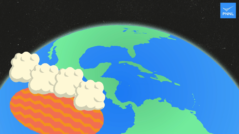
The new study's authors uncovered a previously undescribed mechanism behind the rising coastal hurricane frequency. It begins with relatively stronger warming in the Eastern Pacific Ocean, where the sea surface is typically cooler.
As greenhouse gas emissions continue to climb, they trap more and more heat within the Earth system. This warms both land and sea surfaces, although not uniformly. Most climate models project larger sea surface warming in the Eastern Pacific than the Central Pacific.
As the sea surface warms, more water evaporates from the ocean surface and moistens the air above. Because moist air is less dense, it rises higher in the atmosphere where the moisture condenses to form clouds and releases heat. This process is known as convection.
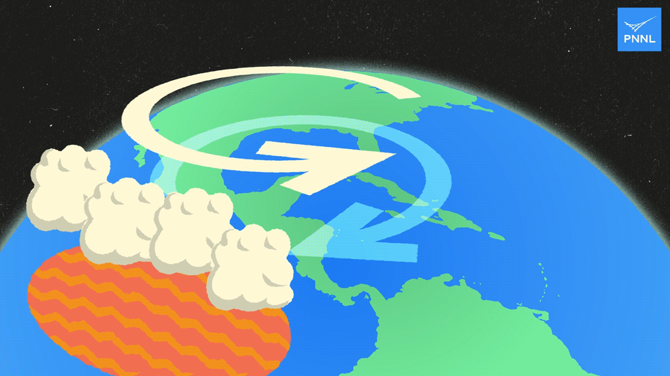
This convection generates a pattern of planetary-scale waves in the atmosphere known as Rossby waves. Though this process begins in the Eastern Pacific, the influence of Rossby waves sprawls great distances. In this case, circulation changes induced by these waves are such that air moves in a clockwise direction close to the surface over the Gulf of Mexico. But higher in the atmosphere, air moves in the opposite direction. In other words, these Rossby waves produce atmospheric circulation patterns like cyclones and anticyclones-PNNL scientists have uncovered such patterns and their effects before.
These waves ultimately trigger changes in the winds in the upper and lower troposphere-winds that steer hurricanes. Take a look at the third animation below. Notice in the upper atmosphere the counterclockwise motion of air induced by the Rossby wave. This motion is what pulls and pushes hurricanes toward the East and Gulf coasts. These changes in the steering winds that determine the path of a hurricane have the added effect of weakening wind shear, making landfalling storms even stronger.
Earlier research into the steering winds that guide hurricanes have made similar projections. But this work marks the first time that scientists have proposed a physical mechanism behind the changes that make coastal storms more damaging in a warmer future.
"Many studies have shed light on how hurricanes will change in the future," said atmospheric scientist and study author Ruby Leung. "By identifying a mechanism that connects the various hurricane changes together, this study offers a more unified perspective underscoring the enhanced coastal hurricane risks in the future."
Some uncertainties remain, according to the study's authors. Better understanding cyclogenesis-the process by which hurricanes form-could help paint a more detailed and accurate picture of hurricane behavior. Further study and better modeling of sea surface warming, too, could lead to more robust and detailed projections.
In their effort to better understand the processes that govern hurricane changes, the team plans to explore how global warming affects tropical cyclones in other coastal regions.
In addition to Balaguru and Leung, PNNL authors include Wenwei Xu, Chuan-Chieh Chang, David Judi, and Samson Hagos. Michael Wehner of Lawrence Berkeley National Laboratory, James Kossin of The Climate Service, and Mingfang Ting of Columbia University are also authors. This work was supported by DOE's Office of Science.


