Rock weathering and water storage appear to follow a pattern across landscapes
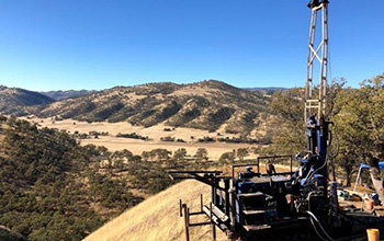
A research drilling rig on a hill slope at the field site in Northern California.
A U.S. National Science Foundation-funded study led by University of Texas at Austin scientists has found that rock weathering and water storage appear to follow a similar pattern across undulating landscapes, where hills rise and fall for miles.
The findings are important because they suggest that these patterns could improve predictions of wildfire, landslide risk, and the effects of drought, since weathering and water storage influence how water and nutrients flow through landscapes.
"There's a lot of momentum to do this work right now," said study co-author Daniella Rempe. "These data, across large scales, are what is needed to inform next-generation models of land-surface processes."
The research was led by Michelle Pedrazas. The results are published in the Journal of Geophysical Research: Earth Surface.
Despite the importance of what's happening inside hills, most computer models for simulating landscape behavior don't go deeper than the soil because of a lack of data that can scale to large areas, Rempe said.
The study helps fill that knowledge gap. It's the first to methodically sample the interiors of a sequence of hill slopes. The research focused on investigating the "critical zone," the near surface layer that includes trees, soils, weathered rock and fractures.
The research site is in Northern California. The scientists drilled 35 boreholes across a series of hill slopes and their valleys to collect subsurface samples. They also collected a core sample at the peak of each hill slope that captured the entire height of the hill -- a distance that varied from 34 to 57 feet (10.5 to 17.5 meters).
The samples revealed deeper weathering and fracturing in hilltops and thinner weathering in valleys. They also revealed weathering that penetrates deeper into shorter hill slopes than taller ones.
The finding suggests that computer models could use this scaling trend to model the extent of weathering in similar undulating terrain.
"More sophisticated knowledge of the patterns of subsurface rock weathering will help in modeling water-storage capacity and landscape stability under a variety of environmental conditions," said Richard Yuretich, a program director in NSF's Division of Earth Sciences.