Mar's enormous spiral ice canyons are young and were formed by erosion
A research with the involvement of the UAB has found the answer to a decades-long mystery: the origin and shape of the ice canyon system in the Martian north polar plateau, one of the solar system's largest megastructures. The research will help better to understand the great environmental changes undergone by the red planet throughout its history.
The UAB participated in a research led by the Planetary Science Institute (PSI) which explains the origin of the system of spiral canyons excavated in the ice of the Martian north polar plateau. Also participating in the study, which was published in Nature-Scientific Reports, were the universities of Purdue and Arizona.
These spiral canyons had already been studied by several scientists who related their distribution with processes of sublimation, in which the ice passes directly from a solid state to gas. However, the origin of the canyons and the spiral form shaping them has remained a mystery during decades.
"Our research suggests that the canyons were formed by a loss of ice due to the action of katabatic winds, which come down from elevated altitudes and exposed ancient ice found on the polar surface", explains Ali M. Bramson, researcher at the University of Purdue.
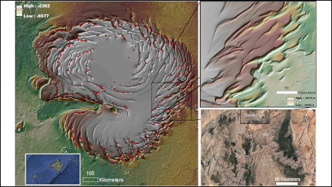
"The discovery implies that the canyons are one of the major megastructures of the solar system, with a total excavated volume of around 10 times that of the Colorado Canyon", points out José Alexis Palmero Rodríguez, PSI researcher and head author of the study. "The emergence of a spiral pattern was caused by intersections fo the canyons as they grew on the dome-shaped geometry of the polar ice cap".
This enormous amount of excavated ice would have been transported by winds and diposited in layers at medium latitudes, and even conserved in mountain glaciers at lower latitudes. "The canyons were formed some millions to 50,000 years ago, during the periods of time when Mars remained in a continuous frozen state. Therefore, this ice would have formed through inverse sublimation, without ending up being liquid. This makes the ice not a candidate that could harbour signs of life. However, for this same reason, we can consider it a possible resource of "pure" water, available for future colonisation missions on Mars. Taking into account that the mass of ince is estimated to be double the size of the Baltic Sea, the availability of this resource could be guaranteed for a long time on the planet", explains Mario Zarroca, researcher from the UAB Department of Geology and co-author of the study.
"One of the main implications of this research is that these canyons have revealed on the walls of the ice a palaeo-climatic register that could cover a period of hundreds of millions of years", Zarroca points out. This register could help better to understand the great changes undergone on Mars throughout its history, such as the evolution of its atmosphere and hydrosphere.
To have a greater perspective, the registries , els registres en gel més antics de la Terra no superen els 3 milions d'anys. "Disposar d'un registre d'alguns centenars de milions d'anys aquí hauria permès investigar el gel de l'època en què els dinosaures encara poblaven la Terra, la qual cosa podria ajudar a aclarir les incògnites que envolten la mega-extinció que va tenir lloc fa uns 66 milions d'anys", assenyala José Alexis Palmero Rodríguez. Un registre tan ampli com el que hauria quedat exposat al casquet polar de Mart ofereix una gran oportunitat per avançar en el coneixement de l'evolució d'aquest planeta, que presenta grans similituds amb el nostre, conclouen els investigadors.
Original article: Rodríguez, J.A.P., Tanaka, K.T., Bramson, A.M., Leonard, G.J., Baker, V.R., Zarroca, M. (2021). North polar trough formation due to in‑situ erosion as a source of young ice in mid‑latitudinal mantles on Mars. Scientific Reports, 11, 6750. https://doi.org/10.1038/s41598-021-83329-3
Image: Left: Model digital d'elevacions del casquet polar nord de Mart que mostra el sistema de canyons espirals. Els punts vermells indiquen la posició de 424 muntanyes i depressions en què són evidents una seqüència de capes concèntriques, la qual cosa posa de manifest que l'erosió in-situ va ser generalitzada. Al costat de l'escala gràfica es reprodueixen les Illes Balears per a un millor context de la grandària del casquet polar. Dreta: Vista de detall d'un sector de l'est del sistema de canyons (a dalt) amb una grandària equivalent al del Canyó del Colorado (a sota).
Credits (upper left and right): digital elevations model: MOLA Science Team, MSS, JPL, NASA and (lower right and Balearic reproduction): Google Earth.


