
Measurements beneath the ocean surface help forecasters predict next week's weather. Experiments show how readings from Argo floats complement satellite observations, improving forecasts of both ocean and atmospheric conditions up to ten days ahead.
Medium-range weather predictions depend on how accurately the atmosphere, ocean, waves and sea ice are represented at the start of the forecast. This is known as the initial condition problem. Since June 2018, the European Centre for Medium-Range Weather Forecasts (ECMWF) has produced operational forecasts with a coupled atmosphere-ocean - waves - sea-ice system. This means that the ocean is no longer treated simply as a fixed boundary beneath the atmosphere; it is an active component of the forecast system, exchanging heat, momentum and freshwater with the atmosphere throughout the prediction.
This coupled approach also enables better use of ocean observations in numerical weather prediction. Because the ocean and sea-ice are integral to the coupled system, their initial conditions can directly influence weather forecast skill. This is particularly important in regions where air-sea interaction is strong, such as the tropics, western boundary currents, the Southern Ocean and storm-track regions. It can also affect high-impact phenomena such as tropical cyclones, where upper-ocean heat content and subsurface thermal structure modulate how much energy is available to the atmosphere.
It is therefore important for the numerical weather prediction community to understand how different ocean observing systems affect operational coupled forecasts, such as those produced by ECMWF's Integrated Forecasting System ( IFS ). Although observation-impact studies are well established for atmospheric observations, equivalent assessments of ocean observing networks remain relatively rare.
The experiments described here assess the impact of ocean observations using a prototype configuration of ECMWF's sixth-generation ocean and sea-ice analysis and reanalysis system, ORAS6 . ORAS6 is designed to provide ocean and sea-ice initial conditions for ECMWF's coupled forecasts across medium-range, sub-seasonal and seasonal timescales. It uses the Nucleus for European Modelling of the Ocean (NEMO) version four ocean model, including the Sea Ice Modelling Integrated Initiative (SI3) multi-category sea-ice model, and an upgraded ocean and sea-ice data assimilation system.
Testing the value of ocean observations
Observing system experiments (OSEs) were conducted by withholding selected observation types from the ocean data assimilation system and assessing their impact in both reanalysis and forecast mode. Using a prototype ORAS6 configuration, the experiments were designed to isolate the contribution of individual components of the ocean observing system. The tested observations included remotely sensed sea-surface temperature (SST), sea-ice concentration and satellite altimetry, as well as in-situ observations such as Argo profiles.
The results presented here are based on experiments designed to closely replicate operational forecasting conditions. Forecasts were produced daily at 00:00 UTC, between June 2021 and June 2022, each covering the following 10 days.
This approach provides two ways to assess the impact of observations. The reanalysis experiments show how observations improve estimates of ocean conditions, while the coupled forecasts show whether the resulting improvements translate into more accurate forecasts of the ocean, waves and atmosphere.
Sea-surface temperature observations have the greatest forecast impact
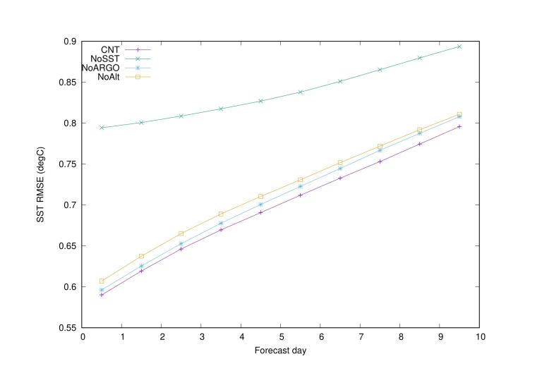
Removing SST observations from the forecasting system causes the greatest overall decline in accuracy among the experiments conducted. The model becomes substantially less accurate at reproducing SSTs measured by drifting ocean buoys, and the negative effects on forecasts persist for up to 10 days (Figure 1).
Subsurface temperature forecasts also degrade (not shown), demonstrating that surface observations help improve estimates of temperatures below the ocean surface, not just at the surface itself.
The atmospheric scorecards (Figure2, middle panel) show substantial negative impacts when SST observations are withheld. This confirms the importance of accurate SST observations for medium-range forecasting. Because SST directly controls the exchange of heat and moisture between the ocean and atmosphere, inaccuracies can quickly affect forecasts of near-surface atmospheric temperature, humidity, wind and wave fields. Such errors can also extend into the upper atmosphere, influencing a wider range of atmospheric variables.
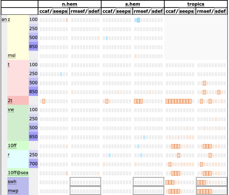
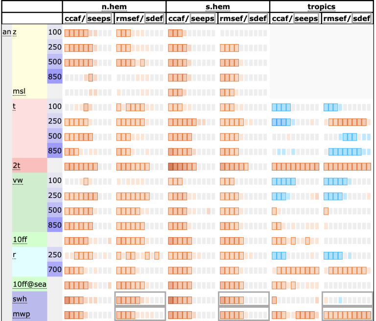
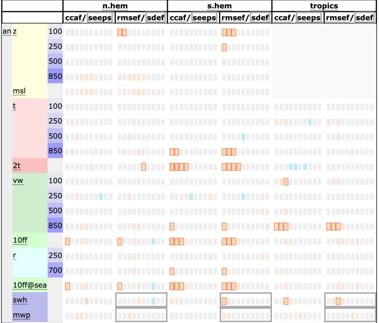
Figure 2. Three-panel summary of Observing System Experiments showing the impact of withholding Argo (upper panel), SST (middle panel) and altimeter (lower panel) observations on atmospheric forecast performance using "scorecards" summarizing the impact on geopotential (z), mean sea-level pressure (msl), upper-air and 2 m temperature (t, 2t), upper-air and 10 m wind (vw, 10ff), humidity (r), 10 m wind over sea (10ff@sea), significant wave height (swh) and mean wind period (mwp). Red colours indicate large RMSE errors against ECMWF operational atmospheric analyses.
A further lesson from this study is that how SST information is incorporated into forecasting models matters. Older approaches gradually adjusted modelled sea-surface temperatures towards observed values, a technique known as SST nudging. The ORAS6/NEMOVAR system uses a more sophisticated method that consistently combines SST and sub-surface temperature measurements with model estimates to produce a more accurate and consistent picture of ocean conditions. This can improve medium-range forecasts, demonstrating that better results depend not only on collecting more observations, but also on making better use of existing data.
Argo: a pivotal observing system for the subsurface ocean
Argo provides near-uniform temperature and salinity measurements from the upper 2000 metres of the ocean, typically every 10 days, through a global network of autonomous floats. These profiles are essential for understanding how heat is stored and distributed throughout the ocean, as satellites can observe surface conditions but cannot directly measure temperature and salinity at depth.
The Argo-focused experiments show that removing Argo data reduces the accuracy of ocean analyses, particularly for subsurface temperature and salinity. However, the impact is not limited to subsurface. Removing Argo also increases errors in sea-surface temperature and height, with notable degradation in regions such as the Atlantic Ocean, the eastern tropical Pacific and areas with strong ocean currents.
When forecasts are produced using ocean analyses that exclude Argo observations, forecast errors increase over the 10-day forecast period (Figure 1). The degradation is visible in SST forecasts and becomes more pronounced over time. Forecasts of ocean subsurface temperature also become less accurate, especially at depths of around 50 metres, when compared with independent in-situ observations.
Removing Argo observations also has a smaller but statistically significant impact on atmospheric forecasts, including air temperature, wind, atmospheric pressure, humidity and wave height (Figure 2, upper panel). These changes are comparable in magnitude to those observed between successive upgrades of the ECMWF forecasting system.
Satellite altimetry and the dynamical ocean state
Satellite altimetry measures variations in sea-surface height, providing information about ocean circulation, currents and regional sea-level changes. The experiment without altimeter observations showed increased errors in SST and subsurface temperature forecasts. The impact on atmospheric forecasts (Figure 2, lower panel) is smaller than when SST observations are withheld, but they are still statistically significant.
Altimetry and Argo provide complimentary information about ocean conditions. While Argo floats measure temperature and salinity profiles at different depths, satellite altimetry tracks variations in sea-surface height across large areas and provides information about ocean circulation and eddy activities. Together, they provide a more complete picture of ocean conditions, both at the surface and below it.
The value of combining observing systems
The experiments also show that the impact of observations depends on which other observing systems are available, how their data are incorporated into forecasting models, and which regions and variables are being assessed.
For example, observations collected directly in the ocean become more important when satellite SST observations are unavailable, although these results are not shown here. This suggests that different observing systems can partly compensate for one another when observations are missing, while also providing complementary information.
These findings highlight the importance of evaluating observing networks together rather than in isolation. They should be assessed as part of an integrated global ocean observing system, where the combined network provides resilience, redundancy and complementary information across variables, depths and regions.
Future priorities
The results show that ocean observations improve much more than just the analysed ocean state. They affect medium-range forecasts of the ocean and waves, while their influence on the atmosphere extends beyond near-surface conditions throughout the atmospheric column, including the upper levels. This strengthens the case for sustained investment in the global ocean observing system.
These findings also highlight the dual route to better forecasts: maintaining and improving the global ocean observing system and continuing to refine how those observations are used in data assimilation.
The second point is crucial. The observation impact study shows that forecast improvements can come not only from new observing platforms but also from better observation processing, improved quality control, more accurate estimates of how model errors are related across different locations and variables, and better assessments of uncertainty in the observations themselves. All these improvements can increase the value extracted from existing observations, complementing future investments in observing networks.
The ECMWF ORAS6 system provides a powerful framework for assessing and designing the global ocean observing network. The OSE framework also offers a practical way to assess which observations matter most, where they matter, and under what system configuration.
Work is ongoing to extend this study to other emerging observing networks, like the Fishing Vessel Ocean Observing Network (FVON), gliders, and animal-borne ocean-sensor data. These observations can provide temperature and salinity profiles in regions that are difficult to sample with conventional platforms, including parts of the high-latitude ocean and in the shallow water regions. They are an emerging component of the Global Ocean Observing System and are being assessed through dedicated OSEs at moment.
As coupled forecasting systems continue to evolve, sustained ocean observations and improved ocean data assimilation will remain essential ingredients for reliable medium-range weather prediction.


