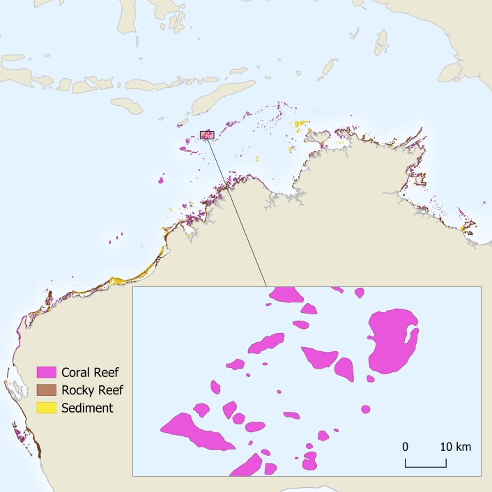
Australian Institute of Marine Science (AIMS) scientists have 'discovered' and mapped more than 1000 previously uncharted coral reefs in northern Australia, all without setting foot on a boat, or even leaving their offices.
Despite being a habitat for a wide range of marine life, and possibly known by locals, reefs from Houtman Abrolhos in Western Australia through to western Cape York in Queensland have until now been mostly invisible and overlooked in conservation and development planning.
The Marine and Coastal Hub project, led by AIMS and run in partnership with the University of Queensland (UQ), unveiled the reefs which are typically hidden in sediment-rich waters.
How it began
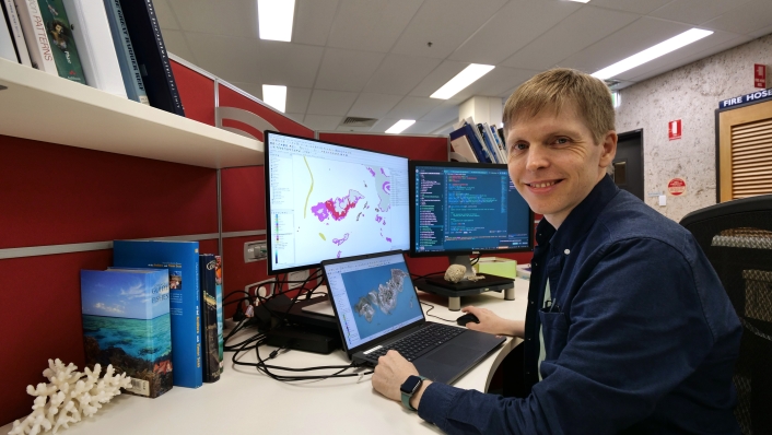
Project Leader, AIMS e-Atlas Project Manager Dr Eric Lawrey said he first got the idea about 12 years ago, when satellite imagery, such as Google Earth, became ubiquitous.
While most of us were googling our homes to see them from space, Dr Lawrey was peering at the northern Australian coastline, noticing what may be coral reefs and wondering why they weren't on any maps.
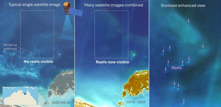
The challenge was that, even on a clear day, it was very difficult to see these reefs as they were often located deep in turbid - or murky - waters.
"If you look at any one satellite image, the water just looks like turquoise paint and you can't really see reefs," he said.
"But if we overlay 200 images of the area, taken at different times, to create a composite image, all the swirly patterns of the moving water move around and average out while the reefs are constant.
"Their signal gets reinforced and they become much clearer. It allows us to peek deeper into the water column than we could in one image.
"And that's pretty much the process we used. Once we could see the reefs, we could map them."
More than meets the eye
Dr Lawrey said this process was done manually as trials using automated techniques proved too prone to false positives at the time.
It took them 700 hours just to digitise the reefs and assign classifications to them.
Dr Lawrey said the work revealed that northern Australia had a similar quantity of reefs as the Great Barrier Reef, albeit many of the reefs were much smaller.
"It's a vast set of reefs that's been largely unknown about," he said.
"Well, I say unknown, maybe I should say unmapped, because I'm sure people that are there, or locals, know about all these places."
Unique reefs
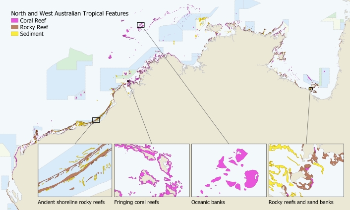
Dr Lawrey said it was amazing how different the reefs were.
"For each area, we needed a different strategy to map the reefs," he said.
"And for a lot of them, we had to learn about the geology of the place before we could map them.
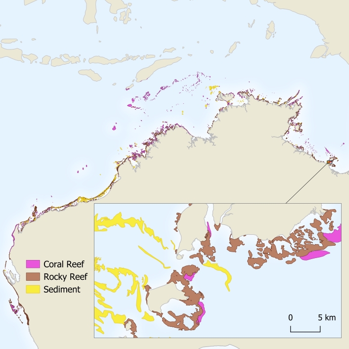
"For example, it took me months to work out how to correctly recognise the reefs through the Kimberley coastline because the structure and shape of them is so different, due to the huge tides there (up to 12m).
"There's also high intertidal coral reefs, that have algal ridges around the outside, like a moat. They have a sort of half a metre lagoon and then a wall that allows the reef to grow vertically up."
Dr Lawrey said that previously, most of the northern Australian coastline was unsurveyed.
The best mapping of northern Australia could be found in the marine charts which did not distinguish between coral reefs and rocky reefs as they were simply designed to warn vessels to stay clear.
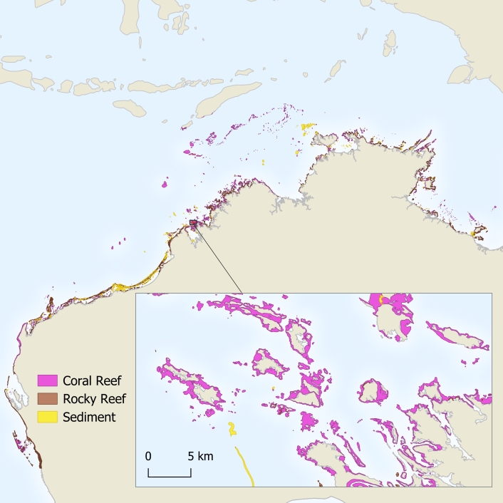
The team mapped and classified reef boundaries to create the first comprehensive view of coral reefs boundaries across northern Australia. This includes more than 3600 coral reefs and 2900 rocky reefs.
"The number of reefs we found inshore was a surprise," he said. "It became a bit of a problem for our project because we had to map so many of them."
Murky reefs now in marine managers' sights
The new maps offer planners, Traditional Owners, and managers a much clearer view of reef and habitat locations.
While the core study area was from Houtman Abrolhos in Western Australia through to western Cape York in Queensland, the team also rolled out the new imagery across the Great Barrier Reef to explore whether additional reefs could be detected.
Dr Lawrey said the timing was ideal because it coincided with a separate UQ project that was remapping the outer reefs of the Great Barrier Reef.
"They adopted our new imagery technique to identify hundreds of additional reefs and to remove false reefs," he said.
This revised dataset is now under review by the Great Barrier Reef Marine Park Authority.
The final datasets are openly available through public data portals, including the eAtlas and AODN.
By revealing what lies beneath northern Australia's coastal waters, this project is supporting stronger protection for marine ecosystems that have long gone unnoticed.

Dr Lawrey led the reef boundary mapping with contributions from Marc Hammerton, Kathryn Markey and colleagues at the University of Queensland, and spatial scientist Rachel Bycroft. The project was supported with funded from the Australian Government under the National Environmental Science Program .


