
The capability will see Police Air Wing's RPAS (remotely piloted aircraft systems) Operations Unit work in conjunction with the State Operations Command Centre (SOCC) to identify incidents where an aerial response could provide valuable information.
Monitoring Computer Aided Dispatch (CAD) jobs, pilots will assess where drones can assist and provide live footage through VGrid, helping SOCC and officers on the ground make more informed decisions as incidents unfold.
This enhanced situational awareness from the air could transform operational decision making.
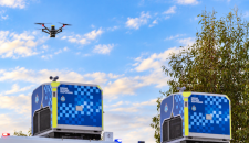
For example, if police receive a report of someone at risk in dense bushland, a drone equipped with thermal imaging could help locate the person and relay their position to ground units.
This could reduce search times and help officers provide assistance sooner.
While the technology offers significant operational benefits, community concerns, particularly around privacy will remain an important consideration. Stakeholder engagement will continue as the capability is introduced and developed.
DFR is being implemented as an operational policing tool to support incident response, not random patrols or general surveillance. Drones will only respond when dispatched to a CAD task.
The program's first flights are planned for Baldivis, Rockingham and Kwinana, with pilots responding to a broad range of jobs where aerial intelligence can add value.
View the Drone as First Responder page


